Sudbrook (stream)

Last updated

Sudbrook
Sudbrook - Richmond Park.jpg
Sudbrook, near Ham Gate and pond, Richmond Park
Richmond upon Thames London UK location map.svg
Red pog.svg
Sudbrook outfall to the Thames at Petersham, London.
EtymologySouth Brook
Location
CountryEngland, United Kingdom
County Greater London
Physical characteristics
Source 
  locationDann's Pond, Richmond Park, Greater London
  coordinates 51°25′40.74″N0°16′47.64″W / 51.4279833°N 0.2799000°W / 51.4279833; -0.2799000
Mouth  
  location
Petersham Meadows, River Thames
  coordinates
51°26′55.34″N0°18′20.88″W / 51.4487056°N 0.3058000°W / 51.4487056; -0.3058000
  elevation
4.5 metres Above Ordnance Datum
Length3.8 km (2.4 mi)
Basin features
Tributaries 
  left Latchmere Stream

Sudbrook and its tributary, the Latchmere stream, are north-flowing streams in London, England, that drain northern Kingston upon Thames and the eastern extreme of Ham following a meander scar in a terrace; the upper part of the Sudbrook drains a narrow vale in Richmond Park's southern corner into the tidal Thames.

Contents

Sudbrook

Dann's Pond, Richmond Park Dann's Pond, Richmond Park, 2 Dec 2012.jpg
Dann's Pond, Richmond Park

The Sudbrook (from 'South brook') rises at the small pond south of Dann's Pond, at about 150 feet (46 m) elevation, [1] in the far south of Richmond Park, flowing NNW to Ham Gate. It forms a small valley, Ham Dip, and has been dammed and enlarged in two places to form 'Ham Dip Pond' and 'Ham Gate Pond', first mapped in 1861 and 1754 respectively. These were created for the watering of deer. [2] Both saw restoration including de-silting, completed in 2013. [3] It drains the western escarpment of the hill that, to the east, forms part of the catchment of Beverley Brook and, to the south, the Hogsmill River.

Ham Gate Pond, fed by Sudbrook Richmond Park - geograph.org.uk - 16252.jpg
Ham Gate Pond, fed by Sudbrook

The Sudbrook is joined by the Latchmere stream just beyond Ham Gate Pond. It then flows into Sudbrook Park, Petersham, and is culverted for the remainder of its course, discharging into the tidal River Thames to the east of 'River Lane' where the culvert outfall is protected from tidal backflow by a flap valve.

Before culverting, the stream used to flow alongside the A307 road in Petersham and was crossed by a ford at Sudbrook Lane. [4] The collapse of this culvert in the late 1970s, referred to as the Petersham Hole, caused widespread traffic disruption for over a year.

Latchmere stream

Latchmere stream outfall pond outside Ham Gate, Richmond Park, December 2012 Latchmere Stream - Ham Woods, Ham Common.jpg
Latchmere stream outfall pond outside Ham Gate, Richmond Park, December 2012
Latchmere stream outfall pond in February 2014 Latchmere Stream - Ham Woods, Ham Common 20140215.jpg
Latchmere stream outfall pond in February 2014

Latchmere probably combines Old French 'lache', lazy or slow-moving and Old English 'mere', a lake or pond; it may however relate to lammas land, a type of common land with church associations.

The Latchmere stream or Latchmere brook started as drainage ditches in the Canbury manor to the north-east of Kingston railway station that, historically in low gradient seasonally flooded. Flooding is abated by some drains in its catchment now draining to the Thames or Hogsmill River and by many soakaways for the roof of homes. Some surface water still drains north-east then north, added to by percolation of water in Richmond Park into the very small, hillside Gallows Pond. Exactly 305 metres of the south of the Kings Road forms its abrupt dip in Richmond Park's south-west side. Owing to flood deposition centuries ago of the untamed river Thames, the Thames/Latchmere watershed (divide), from the town northward shifts eastward e.g. is 220m from Richmond Road, as to Latchmere Road. [5] [6]

The stream's lower course lines the south of the east side of Ham Common, about 50 metres west of Ham Gate of the Richmond Park, via which it joins the Sudbrook just below Ham Gate Pond which together skirt the west side of the Park against the Common.

From Roman to Saxon England or later, the north of Kingston town centre formed a series of island fields formed by a branch of the Hogsmill River and a drainage channel linked to this stream. [7] [8]

With the increase of urbanisation of Kingston in the early 19th century, residents of Canbury used many of their ditches as open sewers, causing a public nuisance and a health hazard: The stench from this ditch, which is an open one, is always bad, but in summer it is beyond words to describe reported the Kingston Board of Guardians on 19 June 1866. [9] This and other open sewers were the cause of serious public health problems, and by in the early 1890s a sewerage works served Kingston, on the Thames. [10] However the slow brook, used as or percolating to the main source of water for a few, still caused some fatal infant diarrhoea and diphtheria. [11] Public information not to drink from streams, ditches or shallow wells in urban zones was widespread by the early 20th century.

Expansion of residential housing across former agricultural land has resulted in the Latchmere stream being culverted, but its course is revealed during periods of heavy rainfall. Its streets are the subject of pluvial flood risk management. [5]

Related Research Articles

<span class="mw-page-title-main">Kingston upon Thames</span> Town in South West London

Kingston upon Thames is a town in the Royal Borough of Kingston upon Thames, southwest London, England. It is situated on the River Thames and 10 miles (16 km) southwest of Charing Cross. It is notable as the ancient market town in which Saxon kings were crowned and today is the administrative centre of the Royal Borough of Kingston upon Thames.

<span class="mw-page-title-main">Petersham, London</span> Human settlement in England

Petersham is a village in the London Borough of Richmond upon Thames on the east of the bend in the River Thames south of Richmond, which it shares with neighbouring Ham. It provides the foreground of the scenic view from Richmond Hill across Petersham Meadows, with Ham House further along the river. Other nearby places include Twickenham, Isleworth, Teddington, Mortlake, and Roehampton.

<span class="mw-page-title-main">Richmond Park</span> Royal Park in London, England

Richmond Park, in the London Borough of Richmond upon Thames, is the largest of London's Royal Parks and is of national and international importance for wildlife conservation. It was created by Charles I in the 17th century as a deer park. It is now a national nature reserve, a Site of Special Scientific Interest and a Special Area of Conservation and is included, at Grade I, on Historic England's Register of Historic Parks and Gardens of special historic interest in England. Its landscapes have inspired many famous artists and it has been a location for several films and TV series.

<span class="mw-page-title-main">River Wandle</span> Tributary of the River Thames, England

The River Wandle is a right-bank tributary of the River Thames in south London, England. With a total length of about 9 miles (14 km), the river passes through the London boroughs of Croydon, Sutton, Merton and Wandsworth, where it reaches the Thames. A short headwater – the Caterham Bourne – is partially in Surrey, the historic county of the river's catchment. Tributaries of the Wandle include Carshalton Ponds and Norbury Brook.

<span class="mw-page-title-main">Teddington Lock</span> Series of locks on the River Thames in London

Teddington Lock is a complex of three locks and a weir on the River Thames between Ham and Teddington in the London Borough of Richmond upon Thames, England. Historically in Middlesex, it was first built in 1810.

<span class="mw-page-title-main">Hogsmill River</span> River in Surrey and Greater London, England

The Hogsmill River in Surrey and Greater London, England is a small chalk stream tributary of the River Thames. It rises in Ewell and flows into the Thames at Kingston upon Thames on the lowest non-tidal reach, that above Teddington Lock.

<span class="mw-page-title-main">Beverley Brook</span> River in London, England

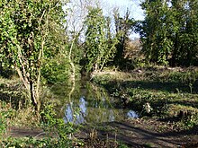
Beverley Brook is a 14.3 km (8.9 mi)-long river in the south-western suburbs of London, England. It rises in Worcester Park and joins the River Thames to the north of the Putney Embankment at Barn Elms, having flowed through the green spaces of Wimbledon Common, Richmond Park, Barnes Common and Putney Lower Common on its course. It is followed for much of its course by the Beverley Brook Walk.

<span class="mw-page-title-main">Richmond Park (UK Parliament constituency)</span> Parliamentary constituency in the United Kingdom

Richmond Park is a constituency in Greater London represented in the House of Commons of the UK Parliament. Since 2019, its Member of Parliament (MP) has been Sarah Olney of the Liberal Democrats.

<span class="mw-page-title-main">Ham, London</span> Area of Richmond in London, England

Ham is a suburban district in Richmond, south-west London. It has meadows adjoining the River Thames where the Thames Path National Trail also runs. Most of Ham is in the London Borough of Richmond upon Thames and, chiefly, within the ward of Ham, Petersham and Richmond Riverside; the rest is in the Royal Borough of Kingston upon Thames. The district has modest convenience shops and amenities, including a petrol station and several pubs, but its commerce is subsidiary to the nearby regional-level economic centre of Kingston upon Thames.

<span class="mw-page-title-main">River Crane, London</span> River in England

The River Crane, a tributary of the River Thames, runs 8.5 miles (13.6 km) in West London, England. It forms the lower course of Yeading Brook. It adjoins or passes through three London boroughs: Hillingdon, Hounslow and Richmond upon Thames, in the historic county of Middlesex. The drainage basin is heavily urbanised but many of the Hayes to Whitton flood-meadows have been conserved, forming a narrow, green vale, opening out to what remains of Hounslow Heath in the centre – a near-continuous belt of semi-natural habitat.

<span class="mw-page-title-main">Parks and open spaces in the Royal Borough of Kingston upon Thames</span>

The Royal Borough of Kingston upon Thames is located along a stretch of the River Thames where the Hogsmill River joins the former at the town of Kingston. The Borough contains over 30 parks, 24 playgrounds, sports grounds and open spaces. There are also over 20 allotments sites which are either self-managed or run by the local council. An assessment conducted in 2006 identified 165 hectares of park and 340 hectares of other open spaces in the borough.

<span class="mw-page-title-main">A307 road</span> Road in southwest London, and northwest Surrey

The A307 road runs 13.2 miles (21.2 km) through SW London and NW Surrey. It is primary at the north-east end; the remainder is non-primary, generally superseded in the mid-twentieth century in two stages by newer alignments of the Portsmouth Road, the Kingston bypass and Esher bypass of the A3, which runs along a slightly oblique axis.

<span class="mw-page-title-main">Richmond Hill, London</span>

Richmond Hill in Richmond, London, is a hill that begins gently in its townside through the former fields, orchards and vineyard to a point just within Richmond Park, the deer park emparked and enclosed by Charles I.

<span class="mw-page-title-main">Falconbrook</span> Covered river in London, England

The Falconbrook was a stream that rose in Balham and Tooting, draining much of those parishes then the south and west of the larger district of Battersea including Clapham Junction to enter the London reaches of the Thames. Before doing so, it briefly formed the border of Wandsworth Town, reflected in the SW11/SW18 boundary today.

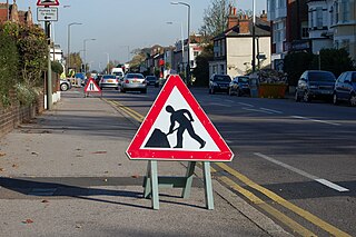
The Petersham Hole was a sink hole caused by subsidence of a sewer which forced the total closure of the A307 road in Petersham in the London Borough of Richmond upon Thames in 1979–80. It caused long-term disruption to traffic in the surrounding area and significant direct and indirect costs.

<span class="mw-page-title-main">Sudbrook Park, Petersham</span>

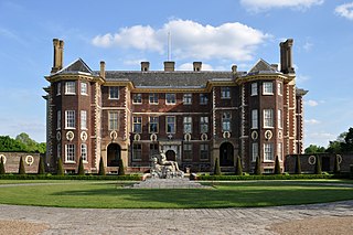
Sudbrook Park in Petersham was developed by John Campbell, 2nd Duke of Argyll in the early 18th century. Sudbrook House, designed for Argyll by James Gibbs and now Grade I listed by Historic England, is considered a fine example of Palladian architecture. The house and its surrounding park have been the home of the Richmond Golf Club since 1891.

<span class="mw-page-title-main">Canbury</span> District in Kingston upon Thames, London

Canbury is a district of the northern part of Kingston upon Thames that takes its name from the historic manor that covered the area. Modern Canbury comprises two electoral wards in the constituency of Richmond Park; Canbury Ward to the south and Tudor Ward to the north.

<span class="mw-page-title-main">Ham Common, London</span> Common land in London

Ham Common is an area of common land in Ham, London. It is a conservation area in, and managed by, the London Borough of Richmond upon Thames. It comprises 48.69 hectares, the second largest area of common land in the borough, 2 acres (0.81 ha) smaller than Barnes Common. It is divided into two distinct habitats, grassland and woodland, separated by the A307, Upper Ham Road. It is an area of ecological, historical and recreational interest, designated a Local Nature Reserve.

<span class="mw-page-title-main">Latchmere Recreation Ground, Kingston upon Thames</span> Public park in the Royal Borough of Kingston upon Thames, London

Latchmere Recreation Ground is a public open space with playing fields and a children's playground in the north of the Royal Borough of Kingston upon Thames.

References

  1. "Explore georeferenced maps – Map images – National Library of Scotland".
  2. McDowall, David (1996). Richmond Park: The Walker's Historical Guide. ISBN   095278470X.
  3. "Work starts on more ponds". Friends of Richmond Park. 2012. Retrieved 27 July 2019.
  4. "History". Petersham Village, Richmond, Surrey. Archived from the original on 3 May 2010. Retrieved 7 July 2020.
  5. 1 2 "SURFACE WATER MANAGEMENT PLAN" (PDF). London Borough of Richmond upon Thames and Royal Borough of Kingston upon Thames. 21 August 2009.[ dead link ]
  6. 'Sheet 006,' in Map of Surrey (Map). 1:10,560. Ordnance Survey. 1871–1882. Retrieved 1 May 2015.
  7. "The Hogsmill River: Life and Times". Kingston upon Thames Archaeological Society. Archived from the original on 10 July 2012. Retrieved 6 March 2020.
  8. Lindsell, David (8 May 2010). "Archaeologists reveal Kingston's history unearthed in past 40 years". Surrey Comet . Retrieved 5 September 2019.
  9. "Fever, Filth & Fear The History of Public Health in Kingston" (PDF). Royal Borough of Kingston upon Thames. Archived from the original (PDF) on 3 November 2012. Retrieved 30 November 2012.
  10. https://maps.nls.uk/geo/explore/#zoom=17&lat=51.41402&lon=-0.29958&layers=168&b=7 Ordnance Survey Map of 1895, National Libraries of Scotland interactive maps
  11. French, Christopher; Warren, Juliet (2004). "Medical officers of health and infant mortality: the case of Kingston upon Thames in the late nineteenth and early twentieth centuries". Faculty of Arts and Social Sciences, Kingston University . Retrieved 13 January 2019.
Next confluence upstream River Thames Next confluence downstream
Hogsmill River (south)Sudbrook (stream) River Crane, London (north)