
A levee, dike, dyke, embankment, floodbank, or stop bank is a structure that is usually earthen and that often runs parallel to the course of a river in its floodplain or along low-lying coastlines.

A floodplain or flood plain or bottomlands is an area of land adjacent to a river. Floodplains stretch from the banks of a river channel to the base of the enclosing valley, and experience flooding during periods of high discharge. The soils usually consist of clays, silts, sands, and gravels deposited during floods.

An entrenched river, or entrenched stream is a river or stream that flows in a narrow trench or valley cut into a plain or relatively level upland. Because of lateral erosion streams flowing over gentle slopes over a time develops meandering course. Meanders form where gradient is very gentle, for example in floodplain and delta. Meandering is the feature of the middle and final course of the river. But very deep and wide meanders can also be found cutting hard rocks. Such meanders are called incised or entrenched meanders. The exception is that entrenched meanders are formed during the upliftment of land where river is young. They widen and deepen over time and can be found as deep gorges or canyons in hard rock. In the case of or either an entrenched stream or river, it is often presumed that the watercourse has inherited its course by cutting down into bedrock from a pre-existing plain with little modification of the original course. The down-cutting of the river system could be the result not only of tectonic uplift but also of other factors such as river piracy, decrease of load, increase of runoff, extension of the drainage basin, or change in base level such as a fall in sea level. General, nongeneric terminology for either a river or stream that flows in a narrow trench or valley, for which evidence of a preexisting plain or relatively level upland can be either absent or present is either valley meander or meander valley with the latter term being preferred in literature.

A braided river, or braided channel, consists of a network of river channels separated by small, often temporary, islands called braid bars or, in British English usage, aits or eyots.

In geography and geology, fluvial processes are associated with rivers and streams and the deposits and landforms created by them. When the stream or rivers are associated with glaciers, ice sheets, or ice caps, the term "glaciofluvial" or "fluvioglacial" is used.
Landforms are categorized by characteristic physical attributes such as their creating process, shape, elevation, slope, orientation, rock exposure, and soil type.
An oxbow lake is a U-shaped lake or pool that forms when a wide meander of a river is cut off, creating a free-standing body of water. In South Texas, oxbows left by the Rio Grande are called resacas. In Australia, oxbow lakes are called billabongs. The word "oxbow" can also refer to a U-shaped bend in a river or stream, whether or not it is cut off from the main stream.

A body of water or waterbody is any significant accumulation of water on the surface of Earth or another planet. The term most often refers to oceans, seas, and lakes, but it includes smaller pools of water such as ponds, wetlands, or more rarely, puddles. A body of water does not have to be still or contained; rivers, streams, canals, and other geographical features where water moves from one place to another are also considered bodies of water.

A riverscape comprises the features of the landscape which can be found on and along a river. Most features of riverscapes include natural landforms but they can also include artificial landforms. Riverscapes can be divided into upper course riverscapes, middle course riverscapes, and lower course riverscapes.

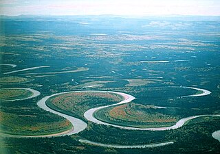
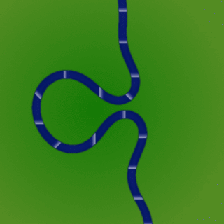
A meander is one of a series of regular sinuous curves in the channel of a river or other watercourse. It is produced as a watercourse erodes the sediments of an outer, concave bank and deposits sediments on an inner, convex bank which is typically a point bar. The result of this coupled erosion and sedimentation is the formation of a sinuous course as the channel migrates back and forth across the axis of a floodplain.
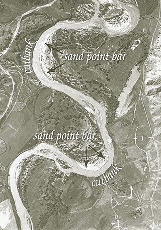
A point bar is a depositional feature made of alluvium that accumulates on the inside bend of streams and rivers below the slip-off slope. Point bars are found in abundance in mature or meandering streams. They are crescent-shaped and located on the inside of a stream bend, being very similar to, though often smaller than, towheads, or river islands.
A cut bank, also known as a river cliff or river-cut cliff, is the outside bank of a curve or meander in a water channel (stream), which is continually undergoing erosion. Cut banks are found in abundance along mature or meandering streams, they are located on the outside of a stream bend, known as a meander, opposite the slip-off slope on the inside of the bend. They are shaped much like a small cliff, and are formed by the erosion of soil as the stream collides with the river bank. As opposed to a point bar, which is an area of deposition, a cut bank is an area of erosion.

A stream is a continuous body of surface water flowing within the bed and banks of a channel. Depending on its location or certain characteristics, a stream may be referred to by a variety of local or regional names. Long, large streams are usually called rivers, while smaller, less voluminous and more intermittent streams are known as streamlets, brooks or creeks.

A river is a natural flowing watercourse, usually a freshwater stream, flowing on the surface or inside caves towards another waterbody at a lower elevation, such as an ocean, sea, bay, lake, wetland, or another river. In some cases, a river flows into the ground or becomes dry at the end of its course without reaching another body of water. Small rivers can be referred to by names such as creek, brook, and rivulet. There are no official definitions for the generic term river as applied to geographic features, although in some countries or communities, a stream is defined by its size. Many names for small rivers are specific to geographic location; examples are "run" in some parts of the United States, "burn" in Scotland and Northeast England, and "beck" in Northern England. Sometimes a river is defined as being larger than a creek, but not always; the language is vague.

A bar in a river is an elevated region of sediment that has been deposited by the flow. Types of bars include mid-channel bars, point bars, and mouth bars. The locations of bars are determined by the geometry of the river and the flow through it. Bars reflect sediment supply conditions, and can show where sediment supply rate is greater than the transport capacity.
River channel migration is the geomorphological process that involves the lateral migration of an alluvial river channel across its floodplain. This process is mainly driven by the combination of bank erosion of and point bar deposition over time. When referring to river channel migration, it is typically in reference to meandering streams. In braided streams, channel change is driven by sediment transport.

An alluvial river is one in which the bed and banks are made up of mobile sediment and/or soil. Alluvial rivers are self-formed, meaning that their channels are shaped by the magnitude and frequency of the floods that they experience, and the ability of these floods to erode, deposit, and transport sediment. For this reason, alluvial rivers can assume a number of forms based on the properties of their banks; the flows they experience; the local riparian ecology; and the amount, size, and type of sediment that they carry.
Dead Timber State Recreation Area is a Nebraska state park in Dodge County, Nebraska in the United States. The park is 200 acres (81 ha) and sits at an elevation of 1,266 feet (386 m). The park is open for year-round recreation including fishing, camping, and non-powered boating. Dead Timber State Recreation Area is north of Scribner on U.S. Route 275.
A meander cutoff is a natural form of a cutting or cut in a river occurs when a pronounced meander (hook) in a river is breached by a flow that connects the two closest parts of the hook to form a new channel, a full loop. The steeper drop in gradient (slope) causes the river flow gradually to abandon the meander which will silt up with sediment from deposition. Cutoffs are a natural part of the evolution of a meandering river. Rivers form meanders as they flow laterally downstream, see sinuosity.

A slip-off slope is a depositional landform that occurs on the inside convex bank of a meandering river. The term can refer to two different features: one in a freely meandering river with a floodplain and the other in an entrenched river.
