Related Research Articles

Larrys Creek is a 22.9-mile-long (36.9 km) tributary of the West Branch Susquehanna River in Lycoming County in the U.S. state of Pennsylvania. A part of the Chesapeake Bay drainage basin, its watershed drains 89.1 square miles (231 km2) in six townships and a borough. The creek flows south from the dissected Allegheny Plateau to the Ridge-and-valley Appalachians through sandstone, limestone, and shale from the Devonian, Mississippian, and Pennsylvanian periods.
Pine Creek is a tributary of the West Branch Susquehanna River in Potter, Tioga, Lycoming, and Clinton counties in Pennsylvania. The creek is 87.2 miles (140.3 km) long. Within Tioga County, 23.25 miles (37.42 km) of Pine Creek are designated as a Pennsylvania Scenic River.

White Deer Hole Creek is a 20.5-mile (33.0 km) tributary of the West Branch Susquehanna River in Clinton, Lycoming and Union counties in the U.S. state of Pennsylvania. A part of the Chesapeake Bay drainage basin, the White Deer Hole Creek watershed drains parts of ten townships. The creek flows east in a valley of the Ridge-and-valley Appalachians, through sandstone, limestone, and shale from the Ordovician, Silurian, and Devonian periods.

Ridley Creek is a tributary of the Delaware River in Chester and Delaware counties, Pennsylvania in the United States.
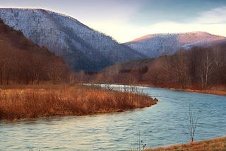
Crooked Creek is a 26.3-mile-long (42.3 km) tributary of the Tioga River located entirely in Tioga County, Pennsylvania in the United States.

Chiques Creek is a 31.6-mile-long (50.9 km) tributary of the Susquehanna River in Lebanon and Lancaster counties, Pennsylvania in the United States.

Cocalico Creek is a 27.2-mile-long (43.8 km) tributary of the Conestoga River in Lebanon and Lancaster counties in Pennsylvania in the United States. The source is at an elevation of 1,320 feet (400 m) near Stricklerstown in Millcreek Township, Lebanon County. The mouth is the confluence with the Conestoga River at an elevation of 278 feet (85 m) at Talmage in West Earl Township, Lancaster County.
Conewago Creek is a 23.0-mile-long (37.0 km) tributary of the Susquehanna River in Lebanon, Dauphin, and Lancaster counties in Pennsylvania in the United States. The source is at an elevation of 1,100 feet (340 m) at Mount Gretna Heights in Lebanon County. The mouth is the confluence with the Susquehanna River at an elevation of 261 feet (80 m) at the border of Dauphin and Lancaster counties, just south of Three Mile Island in the river and just north of the unincorporated village of Falmouth in Conoy Township, Lancaster County.

Conewago Creek is an 80.2-mile-long (129.1 km) tributary of the Susquehanna River in Adams and York counties in Pennsylvania in the United States, with its watershed also draining a small portion of Carroll County, Maryland. The source is at an elevation of 1,440 feet (440 m), east of Caledonia State Park, in Franklin Township in Adams County. The mouth is the confluence with the Susquehanna River at York Haven in York County at an elevation of 259 feet (79 m).
The LeTort Spring Run is a 9.4-mile-long (15.1 km) tributary of Conodoguinet Creek in Cumberland County, Pennsylvania in the United States.

Great Trough Creek is a tributary of the Raystown Branch Juniata River in Bedford, Fulton and Huntingdon counties in Pennsylvania in the United States. The creek is 33.2 miles (53.4 km) long, flows northeast for half its length then northwest, and its watershed is 85.4 square miles (221.2 km2) in area.

A river mile is a measure of distance in miles along a river from its mouth. River mile numbers begin at zero and increase further upstream. The corresponding metric unit using kilometers is the river kilometer. They are analogous to vehicle roadway mile markers, except that river miles are rarely marked on the physical river; instead they are marked on navigation charts, and topographic maps. Riverfront properties are sometimes partially legally described by their river mile.

Wolfhouse Run is a tributary of Little Fishing Creek in Columbia County, Pennsylvania, in the United States. It is approximately 2.9 miles (4.7 km) long and flows through Pine Township. The watershed of the stream has an area of 2.03 square miles (5.3 km2). The steam is considered to be an Exceptional Value stream and a Coldwater Fishery. However, it is considered to be impaired as well. At least two bridges and one sawmill have been built over or on the stream.
Wasp Branch is a tributary of Pine Creek in Luzerne County, Pennsylvania, in the United States. It is approximately 1.7 miles (2.7 km) long and flows through Fairmount Township. The watershed of the stream has an area of 0.90 square miles (2.3 km2). The stream is considered to be Class A Wild Trout Waters, a Coldwater Fishery, and a Migratory Fishery. Glacial till and bedrock consisting of stone and shale can be found in the stream's vicinity.
Leach Creek is a tributary of Leggetts Creek in Lackawanna County, Pennsylvania, in the United States. It is approximately 1.9 miles (3.1 km) long and flows through Scranton. The watershed of the creek has an area of 2.55 square miles (6.6 km2). The creek loses substantial amounts of water to underground mine pools. The creek is in the Coal Region and has been channelized and/or culvertized in some reaches. It flows alongside Pennsylvania Route 307 for a substantial part of its length. The creek has a riparian buffer in its upper and middle reaches, but various invasive plants grow along its banks in its lower reaches.
West Branch Neshaminy Creek is one of two branches of the Neshaminy Creek, the other being the North Branch, part of the Delaware River watershed. It is located in Bucks and Montgomery Counties in Pennsylvania.
Deep Run is a tributary of the Tohickon Creek in Bedminster Township, Bucks County, Pennsylvania in the United States.
Tinicum Creek is a tributary of the Delaware River in Tinicum Township, Bucks County, Pennsylvania. It flows for 6.40 miles (10.30 km) from the confluence of its branches, Beaver Creek and Rapp Creek, before entering the river across from Marshall Island. Tinicum Creek and its two branches are part of the federally-designated Lower Delaware National Wild and Scenic River.
Hollow Run is a tributary of Cooks Creek in Durham Township, Bucks County, Pennsylvania in the United States.
References
- ↑ Shaw, Lewis C. Pennsylvania Gazetteer of Streams Part II (Water Resources Bulletin No. 16). Prepared in Cooperation with the United States Department of the Interior Geological Survey (1st ed.). Harrisburg, PA: Commonwealth of Pennsylvania, Department of Environmental Resources (no ISBN).

| | This article about geography terminology is a stub. You can help Wikipedia by expanding it. |