
A braided river consists of a network of river channels separated by small, often temporary, islands called braid bars or, in British English usage, aits or eyots.

In geography and geology, fluvial processes are associated with rivers and streams and the deposits and landforms created by them. When the stream or rivers are associated with glaciers, ice sheets, or ice caps, the term glaciofluvial or fluvioglacial is used.

In physical geography, a channel is a type of landform consisting of the outline of a path of relatively shallow and narrow body of water, most commonly the confine of a river, river delta or strait. The word often refers to a natural body of water, while the cognate term canal denotes a similar artificial structure.

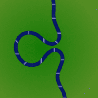
A meander is one of a series of regular sinuous curves in the channel of a river or other watercourse. It is produced as a watercourse erodes the sediments of an outer, concave bank and deposits sediments on an inner, convex bank which is typically a point bar. The result of this coupled erosion and sedimentation is the formation of a sinuous course as the channel migrates back and forth across the axis of a floodplain.

A plunge pool is a deep depression in a stream bed at the base of a waterfall or shut-in. It is created by the erosional forces of cascading water on the rocks at formation's base where the water impacts. The term may refer to the water occupying the depression, or the depression itself.

Upland and lowland are conditional descriptions of a plain based on elevation above sea level. In studies of the ecology of freshwater rivers, habitats are classified as upland or lowland.
The terms river morphology and its synonym stream morphology are used to describe the shapes of river channels and how they change in shape and direction over time. The morphology of a river channel is a function of a number of processes and environmental conditions, including the composition and erodibility of the bed and banks ; erosion comes from the power and consistency of the current, and can effect the formation of the river's path. Also, vegetation and the rate of plant growth; the availability of sediment; the size and composition of the sediment moving through the channel; the rate of sediment transport through the channel and the rate of deposition on the floodplain, banks, bars, and bed; and regional aggradation or degradation due to subsidence or uplift. River morphology can also be affected by human interaction, which is a way the river responds to a new factor in how the river can change its course. An example of human induced change in river morphology is dam construction, which alters the ebb flow of fluvial water and sediment, therefore creating or shrinking estuarine channels. A river regime is a dynamic equilibrium system, which is a way of classifying rivers into different categories. The four categories of river regimes are Sinuous canali- form rivers, Sinuous point bar rivers, Sinuous braided rivers, and Non-sinuous braided rivers.

In a flowing stream, a riffle-pool sequence develops as a stream's hydrological flow structure alternates from areas of relatively shallow to deeper water. This sequence is present only in streams carrying gravel or coarser sediments. Riffles are formed in shallow areas by coarser materials, such as gravel deposits, over which water flows. Pools are deeper, calmer areas whose bed load is made up of finer material such as silt. Streams with only sand or silt laden beds do not develop the feature. The sequence within a stream bed commonly occurs at intervals of from 5 to 7 stream widths. Meandering streams with relatively coarse bed load tend to develop a riffle-pool sequence with pools in the outsides of the bends and riffles in the crossovers between one meander to the next on the opposite margin of the stream. The pools are areas of active erosion and the material eroded tends to be deposited in the riffle areas between them.

A riffle is a shallow landform in a flowing channel. Colloquially, it is a shallow place in a river where water flows quickly past rocks. However, in geology a riffle has specific characteristics.

A stream pool, in hydrology, is a stretch of a river or stream in which the water depth is above average and the water velocity is below average.
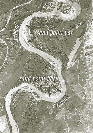
A point bar is a depositional feature made of alluvium that accumulates on the inside bend of streams and rivers below the slip-off slope. Point bars are found in abundance in mature or meandering streams. They are crescent-shaped and located on the inside of a stream bend, being very similar to, though often smaller than, towheads, or river islands.

A drop structure, also known as a grade control, sill, or weir, is a manmade structure, typically small and built on minor streams, or as part of a dam's spillway, to pass water to a lower elevation while controlling the energy and velocity of the water as it passes over. Unlike most dams, drop structures are usually not built for water impoundment, diversion or raising the water level. Mostly built on watercourses with steep gradients, they serve other purposes such as water oxygenation and erosion prevention.

A stream is a continuous body of surface water flowing within the bed and banks of a channel. Depending on its location or certain characteristics, a stream may be referred to by a variety of local or regional names. Long, large streams are usually called rivers, while smaller, less voluminous and more intermittent streams are known as streamlets, brooks or creeks.

A river is a natural flowing watercourse, usually a freshwater stream, flowing on the surface or inside caves towards another waterbody at a lower elevation, such as an ocean, sea, bay, lake, wetland, or another river. In some cases, a river flows into the ground or becomes dry at the end of its course without reaching another body of water. Small rivers can be referred to by names such as creek, brook, and rivulet. There are no official definitions for the generic term river as applied to geographic features, although in some countries or communities, a stream is defined by its size. Many names for small rivers are specific to geographic location; examples are "run" in some parts of the United States, "burn" in Scotland and Northeast England, and "beck" in Northern England. Sometimes a river is defined as being larger than a creek, but not always; the language is vague.
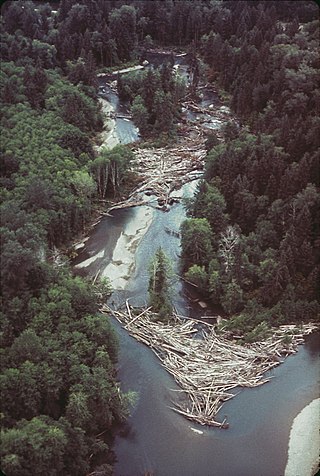
A log jam is a naturally occurring phenomenon characterized by a dense accumulation of tree trunks and pieces of large wood across a vast section of a river, stream, or lake. Log jams in rivers and streams often span the entirety of the water's surface from bank to bank. Log jams form when trees floating in the water become entangled with other trees floating in the water or become snagged on rocks, large woody debris, or other objects anchored underwater. They can build up slowly over months or years, or they can happen instantaneously when large numbers of trees are swept into the water after natural disasters. A notable example caused by a natural disaster is the log jam that occurred in Spirit Lake following a landslide triggered by the eruption of Mount St. Helens. Until they are dismantled by natural causes or humans, log jams can grow quickly, as more wood arriving from upstream becomes entangled in the mass. Log jams can persist for many decades, as is the case with the log jam in Spirit Lake.

A bar in a river is an elevated region of sediment that has been deposited by the flow. Types of bars include mid-channel bars, point bars, and mouth bars. The locations of bars are determined by the geometry of the river and the flow through it. Bars reflect sediment supply conditions, and can show where sediment supply rate is greater than the transport capacity.

An alluvial river is one in which the bed and banks are made up of mobile sediment and/or soil. Alluvial rivers are self-formed, meaning that their channels are shaped by the magnitude and frequency of the floods that they experience, and the ability of these floods to erode, deposit, and transport sediment. For this reason, alluvial rivers can assume a number of forms based on the properties of their banks; the flows they experience; the local riparian ecology; and the amount, size, and type of sediment that they carry.
Channel patterns are found in rivers, streams, and other bodies of water that transport water from one place to another. Systems of branching river channels dissect most of the sub-aerial landscape, each in a valley proportioned to its size. Whether formed by chance or necessity, by headward erosion or downslope convergence, whether inherited or newly formed. Depending on different geological factors such as weathering, erosion, depositional environment, and sediment type, different types of channel patterns can form.

Braid bars, or mid-channel bars, are river landforms typically present in braided river channels. These formations have many names, including medial, longitudinal, crescentic, and transverse bars, as well as the more colloquial sandflat. Braid bars are distinguished from point bars due to their presence in the middle of a flow channel, rather than along a bank of the river channel.
A meander cutoff is a natural form of a cutting or cut in a river occurs when a pronounced meander (hook) in a river is breached by a flow that connects the two closest parts of the hook to form a new channel, a full loop. The steeper drop in gradient (slope) causes the river flow gradually to abandon the meander which will silt up with sediment from deposition. Cutoffs are a natural part of the evolution of a meandering river. Rivers form meanders as they flow laterally downstream, see sinuosity.