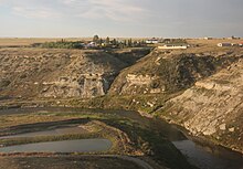
Erosion is the action of surface processes that removes soil, rock, or dissolved material from one location on the Earth's crust, and then transports it to another location where it is deposited. Erosion is distinct from weathering which involves no movement. Removal of rock or soil as clastic sediment is referred to as physical or mechanical erosion; this contrasts with chemical erosion, where soil or rock material is removed from an area by dissolution. Eroded sediment or solutes may be transported just a few millimetres, or for thousands of kilometres.

A valley is an elongated low area often running between hills or mountains, which will typically contain a river or stream running from one end to the other. Most valleys are formed by erosion of the land surface by rivers or streams over a very long period of time. Some valleys are formed through erosion by glacial ice. These glaciers may remain present in valleys in high mountain or polar areas. At lower latitudes and altitudes, these glacially formed valleys may have been created or enlarged during ice ages but now are ice-free and occupied by streams or rivers. In desert areas, valleys may be entirely dry or carry a watercourse only rarely. In areas of limestone bedrock, dry valleys may also result from drainage taking place underground rather than at the surface. Rift valleys arise principally from earth movements, rather than erosion. Many different types of valley are described by geographers, using terms that may be global in use or else applied only locally.

A braided river, or braided channel, consists of a network of river channels separated by small, often temporary, islands called braid bars or, in English usage, aits or eyots.

A slump is a form of mass wasting that occurs when a coherent mass of loosely consolidated materials or a rock layer moves a short distance down a slope. Movement is characterized by sliding along a concave-upward or planar surface. Causes of slumping include earthquake shocks, thorough wetting, freezing and thawing, undercutting, and loading of a slope.

In geography and geology, fluvial processes are associated with rivers and streams and the deposits and landforms created by them. When the stream or rivers are associated with glaciers, ice sheets, or ice caps, the term glaciofluvial or fluvioglacial is used.

In oceanography, geomorphology, and geoscience, a shoal is a natural submerged ridge, bank, or bar that consists of, or is covered by, sand or other unconsolidated material and rises from the bed of a body of water to near the surface. It often refers to those submerged ridges, banks, or bars that rise near enough to the surface of a body of water as to constitute a danger to navigation. Shoals are also known as sandbanks, sandbars, or gravelbars. Two or more shoals that are either separated by shared troughs or interconnected by past or present sedimentary and hydrographic processes are referred to as a shoal complex.
Landforms are categorized by characteristic physical attributes such as their creating process, shape, elevation, slope, orientation, rock exposure, and soil type.
An oxbow lake is a U-shaped lake or pool that forms when a wide meander of a river is cut off, creating a free-standing body of water. In South Texas, oxbows left by the Rio Grande are called resacas. In Australia, oxbow lakes are called billabongs. The word "oxbow" can also refer to a U-shaped bend in a river or stream, whether or not it is cut off from the main stream.

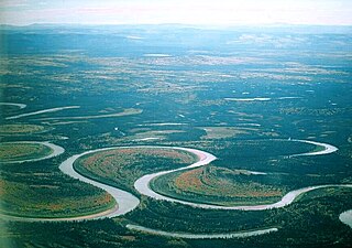
A meander is one of a series of regular sinuous curves in the channel of a river or other watercourse. It is produced as a watercourse erodes the sediments of an outer, concave bank and deposits sediments on an inner, convex bank which is typically a point bar. The result of this coupled erosion and sedimentation is the formation of a sinuous course as the channel migrates back and forth across the axis of a floodplain.

Headward erosion is erosion at the origin of a stream channel, which causes the origin to move back away from the direction of the stream flow, lengthening the stream channel. It can also refer to widening of a canyon by erosion along its very top edge, when sheets of water first enter the canyon from a more roughly planar surface above it, such as at Canyonlands National Park in Utah. When sheets of water on a roughly planar surface first enter a depression in it, this erodes the top edge of the depression. The stream is forced to grow longer at the very top of the stream, which moves its origin back, or causes the canyon formed by the stream to grow wider as the process repeats. Widening of the canyon by erosion inside the canyon, below the canyon side top edge, or origin or the stream, such as erosion caused by the streamflow inside it, is not called headward erosion.

A point bar is a depositional feature made of alluvium that accumulates on the inside bend of streams and rivers below the slip-off slope. Point bars are found in abundance in mature or meandering streams. They are crescent-shaped and located on the inside of a stream bend, being very similar to, though often smaller than, towheads, or river islands.

In sedimentary geology and fluvial geomorphology, avulsion is the rapid abandonment of a river channel and the formation of a new river channel. Avulsions occur as a result of channel slopes that are much less steep than the slope that the river could travel if it took a new course.

In geomorphology, geography and geology, a bench or benchland is a long, relatively narrow strip of relatively level or gently inclined land that is bounded by distinctly steeper slopes above and below it. Benches can be of different origins and created by very different geomorphic processes.

A bar in a river is an elevated region of sediment that has been deposited by the flow. Types of bars include mid-channel bars, point bars, and mouth bars. The locations of bars are determined by the geometry of the river and the flow through it. Bars reflect sediment supply conditions, and can show where sediment supply rate is greater than the transport capacity.
River channel migration is the geomorphological process that involves the lateral migration of an alluvial river channel across its floodplain. This process is mainly driven by the combination of bank erosion of and point bar deposition over time. When referring to river channel migration, it is typically in reference to meandering streams. In braided streams, channel change is driven by sediment transport.

An alluvial river is one in which the bed and banks are made up of mobile sediment and/or soil. Alluvial rivers are self-formed, meaning that their channels are shaped by the magnitude and frequency of the floods that they experience, and the ability of these floods to erode, deposit, and transport sediment. For this reason, alluvial rivers can assume a number of forms based on the properties of their banks; the flows they experience; the local riparian ecology; and the amount, size, and type of sediment that they carry.
Channel patterns are found in rivers, streams, and other bodies of water that transport water from one place to another. Systems of branching river channels dissect most of the sub-aerial landscape, each in a valley proportioned to its size. Whether formed by chance or necessity, by headward erosion or downslope convergence, whether inherited or newly formed. Depending on different geological factors such as weathering, erosion, depositional environment, and sediment type, different types of channel patterns can form.
This glossary of geography terms is a list of definitions of terms and concepts used in geography and related fields, including Earth science, oceanography, cartography, and human geography, as well as those describing spatial dimension, topographical features, natural resources, and the collection, analysis, and visualization of geographic data. Related terms may be found in glossary of geology, glossary of agriculture, glossary of environmental science, and glossary of astronomy.
A meander cutoff is a natural form of a cutting or cut in a river occurs when a pronounced meander (hook) in a river is breached by a flow that connects the two closest parts of the hook to form a new channel, a full loop. The steeper drop in gradient (slope) causes the river flow gradually to abandon the meander which will silt up with sediment from deposition. Cutoffs are a natural part of the evolution of a meandering river. Rivers form meanders as they flow laterally downstream, see sinuosity.

A slip-off slope is a depositional landform that occurs on the inside convex bank of a meandering river. The term can refer to two different features: one in a freely meandering river with a floodplain and the other in an entrenched river.