Related Research Articles

Erosion is the action of surface processes that removes soil, rock, or dissolved material from one location on the Earth's crust and then transports it to another location where it is deposited. Erosion is distinct from weathering which involves no movement. Removal of rock or soil as clastic sediment is referred to as physical or mechanical erosion; this contrasts with chemical erosion, where soil or rock material is removed from an area by dissolution. Eroded sediment or solutes may be transported just a few millimetres, or for thousands of kilometres.

Sediment is a naturally occurring material that is broken down by processes of weathering and erosion, and is subsequently transported by the action of wind, water, or ice or by the force of gravity acting on the particles. For example, sand and silt can be carried in suspension in river water and on reaching the sea bed deposited by sedimentation; if buried, they may eventually become sandstone and siltstone through lithification.

A braided river, or braided channel, consists of a network of river channels separated by small, often temporary, islands called braid bars or, in British English usage, aits or eyots.

In geography and geology, fluvial processes are associated with rivers and streams and the deposits and landforms created by them. When the stream or rivers are associated with glaciers, ice sheets, or ice caps, the term glaciofluvial or fluvioglacial is used.

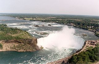
In geology and geomorphology a base level is the lower limit for an erosion process. The modern term was introduced by John Wesley Powell in 1875. The term was subsequently appropriated by William Morris Davis who used it in his cycle of erosion theory. The "ultimate base level" is the plane that results from projection of the sea level under landmasses. It is to this base level that topography tends to approach due to erosion, eventually forming a peneplain close to the end of a cycle of erosion.
Fluvial terraces are elongated terraces that flank the sides of floodplains and fluvial valleys all over the world. They consist of a relatively level strip of land, called a "tread", separated from either an adjacent floodplain, other fluvial terraces, or uplands by distinctly steeper strips of land called "risers". These terraces lie parallel to and above the river channel and its floodplain. Because of the manner in which they form, fluvial terraces are underlain by fluvial sediments of highly variable thickness. River terraces are the remnants of earlier floodplains that existed at a time when either a stream or river was flowing at a higher elevation before its channel downcut to create a new floodplain at a lower elevation. Changes in elevation can be due to changes in the base level of the fluvial system, which leads to headward erosion along the length of either a stream or river, gradually lowering its elevation. For example, downcutting by a river can lead to increased velocity of a tributary, causing that tributary to erode toward its headwaters. Terraces can also be left behind when the volume of the fluvial flow declines due to changes in climate, typical of areas which were covered by ice during periods of glaciation, and their adjacent drainage basins.

A meander is one of a series of regular sinuous curves in the channel of a river or other watercourse. It is produced as a watercourse erodes the sediments of an outer, concave bank and deposits sediments on an inner, convex bank which is typically a point bar. The result of this coupled erosion and sedimentation is the formation of a sinuous course as the channel migrates back and forth across the axis of a floodplain.

In geology, a terrace is a step-like landform. A terrace consists of a flat or gently sloping geomorphic surface, called a tread, that is typically bounded on one side by a steeper ascending slope, which is called a "riser" or "scarp". The tread and the steeper descending slope together constitute the terrace. Terraces can also consist of a tread bounded on all sides by a descending riser or scarp. A narrow terrace is often called a bench.
In geomorphology, a knickpoint or nickpoint is part of a river or channel where there is a sharp change in channel slope, such as a waterfall or lake. Knickpoints reflect different conditions and processes on the river, often caused by previous erosion due to glaciation or variance in lithology. In the cycle of erosion model, knickpoints advance one cycle upstream, or inland, replacing an older cycle. A knickpoint that occurs at the head of a channel is called a headcut. Headcuts resulting in headward erosion are hallmarks of unstable expanding drainage features such as actively eroding gullies.
The terms river morphology and its synonym stream morphology are used to describe the shapes of river channels and how they change in shape and direction over time. The morphology of a river channel is a function of a number of processes and environmental conditions, including the composition and erodibility of the bed and banks ; erosion comes from the power and consistency of the current, and can effect the formation of the river's path. Also, vegetation and the rate of plant growth; the availability of sediment; the size and composition of the sediment moving through the channel; the rate of sediment transport through the channel and the rate of deposition on the floodplain, banks, bars, and bed; and regional aggradation or degradation due to subsidence or uplift. River morphology can also be affected by human interaction, which is a way the river responds to a new factor in how the river can change its course. An example of human induced change in river morphology is dam construction, which alters the ebb flow of fluvial water and sediment, therefore creating or shrinking estuarine channels. A river regime is a dynamic equilibrium system, which is a way of classifying rivers into different categories. The four categories of river regimes are Sinuous canali- form rivers, Sinuous point bar rivers, Sinuous braided rivers, and Non-sinuous braided rivers.

Abrasion is a process of erosion which occurs when material being transported wears away at a surface over time. It is the process of friction caused by scuffing, scratching, wearing down, marring, and rubbing away of materials. The intensity of abrasion depends on the hardness, concentration, velocity and mass of the moving particles. Abrasion generally occurs in four ways: glaciation slowly grinds rocks picked up by ice against rock surfaces; solid objects transported in river channels make abrasive surface contact with the bed and walls; objects transported in waves breaking on coastlines; and by wind transporting sand or small stones against surface rocks.

Stream restoration or river restoration, also sometimes referred to as river reclamation, is work conducted to improve the environmental health of a river or stream, in support of biodiversity, recreation, flood management and/or landscape development.

In sedimentary geology and fluvial geomorphology, avulsion is the rapid abandonment of a river channel and the formation of a new river channel. Avulsions occur as a result of channel slopes that are much less steep than the slope that the river could travel if it took a new course.

An alluvial river is one in which the bed and banks are made up of mobile sediment and/or soil. Alluvial rivers are self-formed, meaning that their channels are shaped by the magnitude and frequency of the floods that they experience, and the ability of these floods to erode, deposit, and transport sediment. For this reason, alluvial rivers can assume a number of forms based on the properties of their banks; the flows they experience; the local riparian ecology; and the amount, size, and type of sediment that they carry.
The term stream power law describes a semi-empirical family of equations used to predict the rate of erosion of a river into its bed. These combine equations describing conservation of water mass and momentum in streams with relations for channel hydraulic geometry and basin hydrology and an assumed dependency of erosion rate on either unit stream power or shear stress on the bed to produce a simplified description of erosion rate as a function of power laws of upstream drainage area, A, and channel slope, S:

Terraces can be formed in many ways and in several geologic and environmental settings. By studying the size, shape, and age of terraces, one can determine the geologic processes that formed them. When terraces have the same age and/or shape over a region, it is often indicative that a large-scale geologic or environmental mechanism is responsible. Tectonic uplift and climate change are viewed as dominant mechanisms that can shape the earth’s surface through erosion. River terraces can be influenced by one or both of these forcing mechanisms and therefore can be used to study variation in tectonics, climate, and erosion, and how these processes interact.

A slip-off slope is a depositional landform that occurs on the inside convex bank of a meandering river. The term can refer to two different features: one in a freely meandering river with a floodplain and the other in an entrenched river.
River incision is the narrow erosion caused by a river or stream that is far from its base level. River incision is common after tectonic uplift of the landscape. Incision by multiple rivers result in a dissected landscape, for example a dissected plateau. River incision is the natural process by which a river cuts downward into its bed, deepening the active channel. Though it is a natural process, it can be accelerated rapidly by human factors including land use changes such as timber harvest, mining, agriculture, and road and dam construction. The rate of incision is a function of basal shear-stress. Shear stress is increased by factors such as sediment in the water, which increase its density. Shear stress is proportional to water mass, gravity, and WSS:
Legacy sediment (LS) is depositional bodies of sediment inherited from the increase of human activities since the Neolithic. These include a broad range of land use and land cover changes, such as agricultural clearance, lumbering and clearance of native vegetation, mining, road building, urbanization, as well as alterations brought to river systems in the form of dams and other engineering structures meant to control and regulate natural fluvial processes (erosion, deposition, lateral migration, meandering). The concept of LS is used in geomorphology, ecology, as well as in water quality and toxicological studies.
Cyclic steps are rhythmic bedforms associated with Froude super-critical flow instability. They are a type of sediment wave, and are created when supercritical sediment-laden water travels downslope through sediment beds. Each ‘step’ has a steep drop, and together they tend to migrate upstream. On the ocean floor, this phenomenon was first shown to be possible in 2006, although it was observed in open-channel flows over a decade earlier. Geological features appearing to be submarine cyclic steps have been detected in the northern lowlands of Mars in the Aeolis Mensae region, providing evidence of an ancient Martian ocean.
References
- ↑ "Estuarine & Floodplain degradation". Eurobodalla Landcare. Archived from the original on 2020-10-12. Retrieved 2009-08-31.
- ↑ Galay, V. J. (1983). "Causes of River Bed Degradation". Water Resources Research. 19 (5): 1057–1090. Bibcode:1983WRR....19.1057G. doi:10.1029/WR019i005p01057.
- Holly, Forrest M.; Karim, M. Fazle (1986). "Simulation of Missouri River Bed Degradation". Journal of Hydraulic Engineering. 112 (6): 497. doi:10.1061/(ASCE)0733-9429(1986)112:6(497).
- Gibling, M.R. (2005). "Discontinuity-Bounded Alluvial Sequences of the Southern Gangetic Plains, India: Aggradation and Degradation in Response to Monsoonal Strength". Journal of Sedimentary Research. 75 (3): 369–385. Bibcode:2005JSedR..75..369G. CiteSeerX 10.1.1.569.1661 . doi:10.2110/jsr.2005.029.
| | This sedimentology article is a stub. You can help Wikipedia by expanding it. |
| | This article about geography terminology is a stub. You can help Wikipedia by expanding it. |