
Erosion is the action of surface processes that removes soil, rock, or dissolved material from one location on the Earth's crust and then transports it to another location where it is deposited. Erosion is distinct from weathering which involves no movement. Removal of rock or soil as clastic sediment is referred to as physical or mechanical erosion; this contrasts with chemical erosion, where soil or rock material is removed from an area by dissolution. Eroded sediment or solutes may be transported just a few millimetres, or for thousands of kilometres.

Till or glacial till is unsorted glacial sediment.

Sediment is a naturally occurring material that is broken down by processes of weathering and erosion, and is subsequently transported by the action of wind, water, or ice or by the force of gravity acting on the particles. For example, sand and silt can be carried in suspension in river water and on reaching the sea bed deposited by sedimentation; if buried, they may eventually become sandstone and siltstone through lithification.
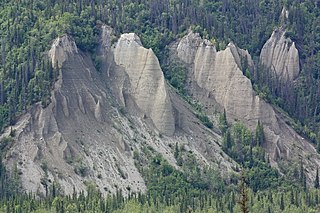
In geography and geology, fluvial sediment processes or fluvial sediment transport are associated with rivers and streams and the deposits and landforms created by sediments. It can result in the formation of ripples and dunes, in fractal-shaped patterns of erosion, in complex patterns of natural river systems, and in the development of floodplains and the occurrence of flash floods. Sediment moved by water can be larger than sediment moved by air because water has both a higher density and viscosity. In typical rivers the largest carried sediment is of sand and gravel size, but larger floods can carry cobbles and even boulders. When the stream or rivers are associated with glaciers, ice sheets, or ice caps, the term glaciofluvial or fluvioglacial is used, as in periglacial flows and glacial lake outburst floods. Fluvial sediment processes include the motion of sediment and erosion or deposition on the river bed.

A streambed or stream bed is the bottom of a stream or river (bathymetry) and is confined within a channel, or the banks (bank of the waterway. Usually the bed does not contain terrestrial vegetation and instead supports different types of aquatic vegetation, depending on the type of streambed material and water velocity. Streambeds are what would be left once a stream is no longer in existence. The beds are usually well preserved even if they get buried because the banks and canyons made by the stream are typically hard, although soft sand and debris often fill the bed. Dry, buried streambeds can actually be underground water pockets. During times of rain, sandy streambeds can soak up and retain water, even during dry seasons, keeping the water table close enough to the surface to be obtainable by local people.

The term bed load or bedload describes particles in a flowing fluid that are transported along the stream bed. Bed load is complementary to suspended load and wash load.
Parent material is the underlying geological material in which soil horizons form. Soils typically inherit a great deal of structure and minerals from their parent material, and, as such, are often classified based upon their contents of consolidated or unconsolidated mineral material that has undergone some degree of physical or chemical weathering and the mode by which the materials were most recently transported.

Hydraulic action, most generally, is the ability of moving water to dislodge and transport rock particles. This includes a number of specific erosional processes, including abrasion, at facilitated erosion, such as static erosion where water leaches salts and floats off organic material from unconsolidated sediments, and from chemical erosion more often called chemical weathering. It is a mechanical process, in which the moving water current flows against the banks and bed of a river, thereby removing rock particles. A primary example of hydraulic action is a wave striking a cliff face which compresses the air in cracks of the rocks. This exerts pressure on the surrounding rock which can progressively crack, break, splinter and detach rock particles. This is followed by the decompression of the air as the wave retreats which can occur suddenly with explosive force which additionally weakens the rock. Cracks are gradually widened so each wave compresses more air, increasing the explosive force of its release. Thus, the effect intensifies in a 'positive feedback' system. Over time, as the cracks may grow they sometimes form a sea cave. The broken pieces that fall off produce two additional types of erosion, abrasion (sandpapering) and attrition. In corrasion, the newly formed chunks are thrown against the rock face. Attrition is a similar effect caused by eroded particles after they fall to the sea bed where they are subjected to further wave action. In coastal areas wave hydraulic action is often the most important form of erosion.
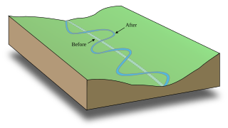
A meander is one of a series of regular sinuous curves in the channel of a river or other watercourse. It is produced as a watercourse erodes the sediments of an outer, concave bank and deposits sediments on an inner, convex bank which is typically a point bar. The result of this coupled erosion and sedimentation is the formation of a sinuous course as the channel migrates back and forth across the axis of a floodplain.
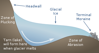
Plucking, also referred to as quarrying, is a glacial phenomenon that is responsible for the weathering and erosion of pieces of bedrock, especially large "joint blocks". This occurs in a type of glacier called a "valley glacier". As a glacier moves down a valley, friction causes the basal ice of the glacier to melt and infiltrate joints (cracks) in the bedrock. The freezing and thawing action of the ice enlarges, widens, or causes further cracks in the bedrock as it changes volume across the ice/water phase transition, gradually loosening the rock between the joints. This produces large chunks of rock called joint blocks. Eventually these joint blocks come loose and become trapped in the glacier.

Sediment transport is the movement of solid particles (sediment), typically due to a combination of gravity acting on the sediment, and the movement of the fluid in which the sediment is entrained. Sediment transport occurs in natural systems where the particles are clastic rocks, mud, or clay; the fluid is air, water, or ice; and the force of gravity acts to move the particles along the sloping surface on which they are resting. Sediment transport due to fluid motion occurs in rivers, oceans, lakes, seas, and other bodies of water due to currents and tides. Transport is also caused by glaciers as they flow, and on terrestrial surfaces under the influence of wind. Sediment transport due only to gravity can occur on sloping surfaces in general, including hillslopes, scarps, cliffs, and the continental shelf—continental slope boundary.

Abrasion is a process of erosion that occurs when material being transported wears away at a surface over time, commonly happens in ice and glaciers. The primary process of abrasion is physical weathering. Its the process of friction caused by scuffing, scratching, wearing down, marring, and rubbing away of materials. The intensity of abrasion depends on the hardness, concentration, velocity and mass of the moving particles. Abrasion generally occurs in four ways: glaciation slowly grinds rocks picked up by ice against rock surfaces; solid objects transported in river channels make abrasive surface contact with the bed and walls; objects transported in waves breaking on coastlines; and by wind transporting sand or small stones against surface rocks. Abrasion is the natural scratching of bedrock by a continuous movement of snow or glacier downhill. This is caused by a force, friction, vibration, or internal deformation of the ice, and by sliding over the rocks and sediments at the base that causes the glacier to move.
Attrition is the process of erosion that occurs during rock collision and transportation. The transportation of sediment chips and smooths the surfaces of bedrock; this can be through water or wind. Rocks undergoing attrition erosion are often found on or near the bed of a stream. Attrition is also partially responsible for turning boulders into smaller rocks and eventually to sand.

In hydrology and geography, armor is the association of surface pebbles, rocks or boulders with stream beds or beaches. Most commonly hydrological armor occurs naturally; however, a man-made form is usually called riprap, when shorelines or stream banks are fortified for erosion protection with large boulders or sizable manufactured concrete objects. When armor is associated with beaches in the form of pebbles to medium-sized stones grading from two to 200 millimeters across, the resulting landform is often termed a shingle beach. Hydrological modeling indicates that stream armor typically persists in a flood stage environment.

Stream load is a geologic term referring to the solid matter carried by a stream. Erosion and bed shear stress continually remove mineral material from the bed and banks of the stream channel, adding this material to the regular flow of water. The amount of solid load that a stream can carry, or stream capacity, is measured in metric tons per day, passing a given location. Stream capacity is dependent upon the stream's velocity, the amount of water flow, and the gradation.

A river is a natural flowing watercourse, usually a freshwater stream, flowing on the Earth's land surface or inside caves towards another waterbody at a lower elevation, such as an ocean, sea, bay, lake, wetland, or another river. In some cases, a river flows into the ground or becomes dry at the end of its course without reaching another body of water. Small rivers can be referred to by names such as creek, brook, and rivulet. There are no official definitions for these various generic terms for a watercourse as applied to geographic features, although in some countries or communities, a stream is customarily referred to by one of these names as determined by its size. Many names for small rivers are specific to geographic location; examples are "run" in some parts of the United States, "burn" in Scotland and Northeast England, and "beck" in Northern England. Sometimes a river is defined as being larger than a creek, but not always; the language is vague.
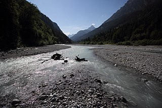
An alluvial river is one in which the bed and banks are made up of mobile sediment and/or soil. Alluvial rivers are self-formed, meaning that their channels are shaped by the magnitude and frequency of the floods that they experience, and the ability of these floods to erode, deposit, and transport sediment. For this reason, alluvial rivers can assume a number of forms based on the properties of their banks; the flows they experience; the local riparian ecology; and the amount, size, and type of sediment that they carry.
Channel patterns are found in rivers, streams, and other bodies of water that transport water from one place to another. Systems of branching river channels dissect most of the sub-aerial landscape, each in a valley proportioned to its size. Whether formed by chance or necessity, by headward erosion or downslope convergence, whether inherited or newly formed. Depending on different geological factors such as weathering, erosion, depositional environment, and sediment type, different types of channel patterns can form.

In hydrology stream competency, also known as stream competence, is a measure of the maximum size of particles a stream can transport. The particles are made up of grain sizes ranging from large to small and include boulders, rocks, pebbles, sand, silt, and clay. These particles make up the bed load of the stream. Stream competence was originally simplified by the “sixth-power-law,” which states the mass of a particle that can be moved is proportional to the velocity of the river raised to the sixth power. This refers to the stream bed velocity which is difficult to measure or estimate due to the many factors that cause slight variances in stream velocities.
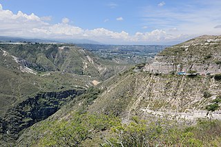
River incision is the narrow erosion caused by a river or stream that is far from its base level. River incision is common after tectonic uplift of the landscape. Incision by multiple rivers result in a dissected landscape, for example a dissected plateau. River incision is the natural process by which a river cuts downward into its bed, deepening the active channel. Though it is a natural process, it can be accelerated rapidly by human factors including land use changes such as timber harvest, mining, agriculture, and road and dam construction. The rate of incision is a function of basal shear-stress. Shear stress is increased by factors such as sediment in the water, which increase its density. Shear stress is proportional to water mass, gravity, and WSS:
4. Whipple, K. X., DiBiase, R. A., & Crosby, B. T. (2013). Bedrock Rivers. In Fluvial Geomorphology (Vol. 9, pp. 550-573). Elsevier Inc.. https://doi.org/10.1016/B978-0-12-374739-6.00254-2


