
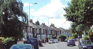
Leyton is a town in East London, England, within the London Borough of Waltham Forest. It borders Walthamstow to the north, Leytonstone to the east, and Stratford to the south, with Clapton, Hackney Wick and Homerton, across the River Lea, to the west. The area includes New Spitalfields Market, Leyton Orient Football Club, as well as part of the Queen Elizabeth Olympic Park. The town consists largely of terraced houses built between 1870 and 1910, interspersed with some modern housing estates. It is 6.2 miles (10 km) north-east of Charing Cross.

Snaresbrook is a district of East London in the London Borough of Redbridge. It is located 8 miles east of Charing Cross.

Walthamstow is a large town in east London, England, within the ceremonial county of Greater London and the ancient county of Essex. Situated 7+1⁄2 miles northeast of Charing Cross, the town borders Chingford to the north, Snaresbrook and South Woodford to the east, Leyton and Leytonstone to the south, and Tottenham to the west. At the 2011 census, the town had a population of approximately 109,424.

The London Borough of Waltham Forest is a London borough in north-east London, England. Its population is estimated to be 276,983 in 2019. It borders five other London boroughs: Enfield to the north-west, Haringey to the west, Hackney to the south-west, Newham to the south-east and Redbridge to the east, as well as the non-metropolitan county of Essex to the north.

Leytonstone is an area in east London, England, within the London Borough of Waltham Forest. Situated 7 miles (11 km) north-east of Charing Cross, it adjoins Wanstead to the east, Forest Gate to the south-east, Stratford to the south-west, Leyton to the west, and Walthamstow to the north-west.
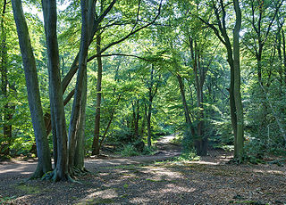
Epping Forest is a 2,400-hectare (5,900-acre) area of ancient woodland, and other established habitats, which straddles the border between Greater London and Essex. The main body of the forest stretches from Epping in the north, to Chingford on the edge of the London built-up area. South of Chingford the forest narrows, and forms a green corridor that extends deep into East London, as far as Forest Gate.

Leyton is a London Underground station in Leyton, in the London Borough of Waltham Forest, East London. Located on Leyton High Road, adjacent to the A12, the station is on the Central line between two stations assigned to two fare zones – Stratford and Leytonstone. It is in zone 3.

The A11 is a major trunk road in England. It runs roughly north east from London to Norwich, Norfolk, although after the M11 opened in the 1970s and then the A12 extension in 1999, a lengthy section has been downgraded between the suburbs of east London and the north-west corner of the county of Essex. It also multiplexes/overlaps with the A14 on the Newmarket bypass.

Leytonstone is a London Underground station in Leytonstone in the London Borough of Waltham Forest, east London. It is on the Central line, on the boundary of Zones 3 and 4. Towards Central London the next station is Leyton, while going east from Leytonstone, the line divides into two branches. On the direct route to Woodford and Epping the next stop is Snaresbrook, and on the Hainault loop it is Wanstead. The station is close to Whipps Cross University Hospital.

South Woodford is an area of East London, England, within the London Borough of Redbridge. It adjoins Woodford Green to the north, Walthamstow to the west, Snaresbrook and Wanstead to the south and Redbridge to the east, and is 8.9 miles (14.3 km) north-east of Charing Cross.

Leyton was a local government district in southwest Essex, England, from 1873 to 1965. It included the neighbourhoods of Leyton, Leytonstone and Cann Hall. It was suburban to London, forming part of the London postal district and Metropolitan Police District. It now forms the southernmost part of the London Borough of Waltham Forest in Greater London.

Whipps Cross University Hospital is a large university hospital in the locality of Whipps Cross in Leytonstone and is within Epping Forest in the London Borough of Waltham Forest, London, England. It is managed by Barts Health NHS Trust.
Cann Hall is a ward, and former civil parish, in the south of Leytonstone in the London Borough of Waltham Forest. It is north of Stratford and Forest Gate, east of Leyton, and west of Wanstead Flats, the southernmost tip of Epping Forest.
Wanstead Flats is the southernmost portion of Epping Forest, in Leytonstone and Wanstead, London. The flats and by extension the forest ends at Forest Gate directly to the south. It now falls wholly within the boundaries of the London Boroughs of Redbridge and Waltham Forest, though until 1994 two parts of it were in the London Borough of Newham: one of these was the section between Aldersbrook Road and Capel Road east of the junction between Aldersbrook Road and St Margaret's Road, whilst the other was the strip running along Capel Road between its junctions with Centre Road and Ridley Road. As part of Epping Forest, the Flats is managed by the City of London Corporation.

Bakers Arms is an intersection and arguably a district on the boundary of Leyton and Walthamstow, in the London Borough of Waltham Forest. It is named after a former public house which stood at the junction of High Road Leyton, Hoe Street and Lea Bridge Road (A104). The pub's name was derived from the nearby almshouses for members of London's baking trade, which were completed in 1866. The first record of a publican at the Baker's Arms was in 1868. The pub closed in 2010, and the premises now operate as a betting shop. There are several food stores, pubs and cafes, and a variety of other retail outlets.

Whipps Cross is an area of the districts of Leytonstone and Walthamstow in the London Borough of Waltham Forest in London, England. It is most famous for Whipps Cross University Hospital.

The A102 is a road that starts in Clapton in north east London in the London Borough of Hackney and ends by merging into the A2 road just south of the Sun in the Sands roundabout in south east London in the Royal Borough of Greenwich. The A102 was formerly a continuous route including two motorway sections classified as the A102(M), but road renumbering means that it is separated into two sections linked by the A106 and the A12, one consisting of non-primary urban roads and the other a primary dual carriageway south of the river. The route includes the Blackwall Tunnel.

Lea Bridge Road is a major through route in east London, across the Lea Valley from Clapton to Whipps Cross in Leyton. It forms part of the A104 road.
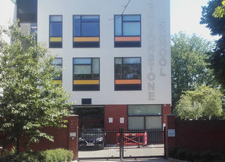
Leytonstone School is a coeducational community secondary school located on Colworth Road in Leytonstone, London, England.

"Hollow Ponds" is the third single by Damon Albarn from his debut solo album, Everyday Robots. It was released as a single in digital formats on 19 April 2014, via Warner Bros. Records in the US. Hollow Ponds is the name of a lake in Leytonstone, East London, where Albarn grew up, and the song references several events from his life. The song contains a sample of a Central line train leaving Leytonstone station on the London Underground.


