
Brentford is a suburban town in West London, England and part of the London Borough of Hounslow. It lies at the confluence of the River Brent and the Thames, 8 miles (13 km) west of Charing Cross.

Chiswick is a district in the London Borough of Hounslow, West London, England. It contains Hogarth's House, the former residence of the 18th-century English artist William Hogarth; Chiswick House, a neo-Palladian villa regarded as one of the finest in England; and Fuller's Brewery, London's largest and oldest brewery. In a meander of the River Thames used for competitive and recreational rowing, with several rowing clubs on the river bank, the finishing post for the Boat Race is just downstream of Chiswick Bridge.

The London Borough of Hounslow is a London borough in west London, England, forming part of Outer London. It is governed by Hounslow London Borough Council.
Hanwell is a town in the London Borough of Ealing. It is about 1.5 miles (2.4 km) west of Ealing Broadway and had a population of 28,768 as of 2011. It is the westernmost location of the London post town.
Ealing is a district in west London, England, 7.5 miles (12.1 km) west of Charing Cross in the London Borough of Ealing. It is the administrative centre of the borough and is identified as a major metropolitan centre in the London Plan.

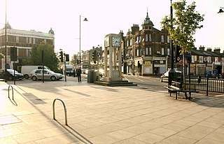
West Ealing is a district in the London Borough of Ealing, in West London. The district is about three-quarters of a mile (1.2 km) west of Ealing Broadway. Although there is a long history of settlement in the area, West Ealing in its present form is less than one hundred years old. West Ealing falls under the postcode district W13 and neighbours Hanwell, Ealing, Perivale and Northfields

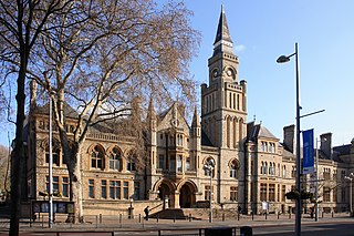
Pitzhanger Manor is an English country house famous as the home of neoclassical architect, Sir John Soane. Built between 1800 and 1804 in what is now Walpole Park Ealing, to the west of London), the Regency Manor is a rare and spectacular example of a building designed, built and lived in by Sir John Soane himself. Soane intended it as a domestic space to entertain guests in, as well as a family home for a dynasty of architects, starting with his sons.
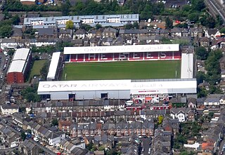
Griffin Park was a football ground in Brentford in the London Borough of Hounslow, England. It was the home ground of Brentford F.C. from its opening in September 1904 to August 2020. The ground was in a predominantly residential area and was known for being the only English league football ground to have a pub on each corner. The ground's name referred to the griffin featured in the logo of Fuller's Brewery, which at one point owned the orchard on which the stadium was built.
Ealing was a local government district from 1863 to 1965 around the town of Ealing which formed part of the built up area of London until 1965, where it became part of Greater London.

Ossulstone is an obsolete subdivision (hundred) covering 26.4% of – and the most metropolitan part – of the historic county of Middlesex, England. It surrounded but did not include the City of London and the area has been entirely absorbed by the growth of London. It now corresponds to the seven London Boroughs of Inner London north of the Thames and, from Outer London, in decreasing order, certain historic parishes of the London boroughs of Ealing, Brent, Barnet, and Haringey.

London Buses route 65 is a Transport for London contracted bus route in London, England. Running between Ealing Broadway station and Kingston upon Thames, it is operated by RATP Dev Transit London.

Northfields is an area in Ealing, west London. It is centred on Northfield Avenue, a shopping street of mostly independent shops and restaurants. It lies partially in the Ealing W5 and partially in west Ealing's W13 postcode. It lies in the southwest corner of Ealing.

Brentford Ait is a long 4.572-acre (1.9 ha) uninhabited ait in the River Thames, without buildings, on the Tideway near Brentford in London, England.
Charles Jones was Ealing's first architect, engineer and surveyor. He held these posts for fifty years, and is known for his work on civic buildings.

William George Barker was a British film producer, director, cinematographer, and entrepreneur who took film-making in Britain from a low budget form of novel entertainment to the heights of lavishly-produced epics that were matched only by Hollywood for quality and style.
Acton Green is a residential neighbourhood in Chiswick and the London Borough of Ealing, in West London, England. It is named for the nearby Acton Green common. It was once home to many small laundries and was accordingly known as "Soapsuds Island".

Brentford Dock in Brentford, west London, was a major trans-shipment point between the Great Western Railway (GWR) and barges on the River Thames. The building of Brentford Dock was started in 1855 and it was formally opened in 1859. The former dock yard was redeveloped in 1972 and is now Brentford Dock Marina and Brentford Dock Estate.

Harvington Prep Schooland Nursery is an independent school in Ealing, West London. Founded in 1890 as a kindergarten called Heidelberg College, the school was renamed Harvington College during World War I. For much of its history, it operated as a private girls' school for ages three to eighteen, with boys included at nursery, and occupied three modernised Victorian houses on Castlebar Road. In 2010, Harvington School closed its senior school, focusing instead on its preparatory school. Most recently, it has been co-educational up to Year 2, with girls continuing through Year 6. In April 2022, Harvington Prep announced that it would merge with Durston House, a neighbouring boys' school, to form a single co-educational school in September 2023.

The Fox Inn is a public house in Green Lane, Hanwell, in the London Borough of Ealing. Built in 1848, it is a largely unspoilt and original mid-Victorian pub. It has received a 'local listing' from Ealing Council as a building of local interest.


