
The Northern line is a London Underground line that runs from north to south London. It is printed in black on the Tube map. The Northern line is unique on the Underground network in having two different routes through central London, two southern branches and two northern branches. Despite its name, it does not serve the northernmost stations on the Underground, though it does serve the southernmost station at Morden, the terminus of one of the two southern branches.

The London Borough of Islington is a London borough in Inner London. The borough includes a significant area to the south which forms part of central London. Islington has an estimated population of 215,667. It was formed in 1965 under the London Government Act 1963, which simultaneously abolished the metropolitan boroughs of Islington and Finsbury.

Highgate is a suburban area of north London at the northeastern corner of Hampstead Heath, 4.5 miles (7.2 km) north-northwest of Charing Cross.

Highgate is a London Underground station and former railway station in Archway Road, in the London Borough of Haringey in north London. The station takes its name from nearby Highgate Village. It is on the High Barnet branch of the Northern line, between Archway and East Finchley stations, and is in Travelcard Zone 3.
Holloway Road is a road in London, 3 kilometres (1.9 mi) in length. It is one of the main shopping streets in North London, and carries the A1 road as it passes through Holloway, in the London Borough of Islington. The road starts at the Archway, near Archway Underground station, then heads south-east, past Upper Holloway railway station, Whittington Park, past the North London campus of London Metropolitan University near Nag's Head, past Holloway Road Underground station, and the main campus of the university, and then becomes Highbury Corner, near Highbury & Islington station.

Crouch End is an area of North London, approximately five miles (8 km) from the City of London in the western half of the borough of Haringey. It is within the Hornsey postal district (N8).

The Angel, Islington, is a historic landmark and a series of buildings that have stood on the corner of Islington High Street and Pentonville Road in Islington, London, England. The land originally belonged to the Clerkenwell Priory and has had various properties built on it since the 16th century. An inn on the site was called the "Angel Inn" by 1614, and the crossing became generally known as "the Angel". The site was bisected by the New Road, which opened in 1756, and properties on the site have been rebuilt several times up to the 20th century. The corner site gave its name to Angel tube station, opened in 1901, and the surrounding Angel area of London.

Archway is a London Underground station at the intersection of Holloway Road, Highgate Hill, Junction Road and Archway Road in Archway, north London, directly underneath the Vantage Point building. It is on the High Barnet branch of the Northern line, between Highgate and Tufnell Park stations, in Zones 2 and 3.

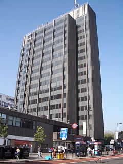
Archway is an area of north London, England, within the London Borough of Islington. It is located 3.8 miles (6 km) north of Charing Cross. It is identified as a district centre in the London Plan, and is surrounded by mixed-density residential development. It straddles the A1 in London and is named after an erstwhile local landmark, the high, single-arched Archway Bridge which crossed the road in a cutting to the north. It has a modern commercial hub around Vantage Point and Archway tube station.

Whittington Hospital is a district general and teaching hospital of UCL Medical School and Middlesex University School of Health and Social Sciences. Located in Upper Holloway, it is managed by Whittington Health NHS Trust, operating as Whittington Health, an integrated care organisation providing hospital and community health services in the north London boroughs of Islington and Haringey. Its Jenner Building, a former smallpox hospital, is a Grade II listed building.

The Parkland Walk is a 3.1-mile (5.0 km) linear green pedestrian and cycle route in London, which follows the course of the railway line that used to run between Finsbury Park and Alexandra Palace, through Stroud Green, Crouch End, Highgate and Muswell Hill. It is often mistakenly described as 4.5 miles long, but even taking in the gap between the two sections it still only totals 3.1 miles (5.0 km). The route follows the bridges and cuttings of the line, but avoids the closed surface section of Highgate station and its adjoining tunnels, which are closed to walkers for safety reasons. The walk is almost all in Haringey, but a short stretch between Crouch Hill and Crouch End Hill is in Islington and this section incorporates Crouch Hill Park.

The Charing Cross, Euston and Hampstead Railway (CCE&HR), also known as the Hampstead Tube, was a railway company established in 1891 that constructed a deep-level underground "tube" railway in London. Construction of the CCE&HR was delayed for more than a decade while funding was sought. In 1900 it became a subsidiary of the Underground Electric Railways Company of London (UERL), controlled by American financier Charles Yerkes. The UERL quickly raised the funds, mainly from foreign investors. Various routes were planned, but a number of these were rejected by Parliament. Plans for tunnels under Hampstead Heath were authorised, despite opposition by many local residents who believed they would damage the ecology of the Heath.

St Aloysius' College is a Roman Catholic, boys only state school in the London Borough of Islington, North London. Each year around 180 pupils are admitted to Year 7 on the basis of examination, however the local education authority also assigns students without a school to this school. It is the oldest surviving foundation of its kind in the Archdiocese of Westminster.

Camden Passage is a picturesque car-free London street minutes from the Angel tube station off Upper Street in the London Borough of Islington. The passage is known for its antique shops, markets and its array of independent shops, cafes, and restaurants.

The A1 in London is the southern part of the A1 road. It starts at Aldersgate in the City of London, passing through the capital to Borehamwood on the northern fringe of Greater London, before continuing to Edinburgh. The road travels through the City and three London boroughs: Islington, Haringey and Barnet, which include the districts of Islington, Holloway, Highgate, Hendon and Mill Hill, and travels along Upper Street and Holloway Road, crossing the North Circular Road in Hendon, a district in the London Borough of Barnet.

The Magdala, also known as The Magdala Tavern or colloquially as simply The Magy, is a public house on South Hill Park in Hampstead and was named after the British victory in the 1868 Battle of Magdala. It later became infamous as the pub outside which Ruth Ellis, the last woman to be executed in Great Britain, shot her boyfriend in 1955.

The Winchester is a former public house at 206 Archway Road, Highgate, London N6 5BA.

The Intrepid Fox was a pub at 97–99 Wardour Street, Soho, London, established in 1784 by the publican Samuel House, who named it after the prominent British Whig statesman Charles James Fox. The pub was located on the corner of Wardour Street and Peter Street.

The Bomb Factory Art Foundation is an artist-led foundation with exhibition space for contemporary art, based in Archway, Islington, London, England.
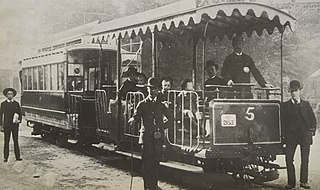
The Highgate Hill Cable Tramway was the first cable tramway in Europe. Opened in 1884, it was built to demonstrate the benefits of the technology first pioneered in San Francisco.

