
The Pineapple is a Grade II listed public house at 51 Leverton Street, Kentish Town, London. [1]
It was built in about 1868. [1]
The Pineapple is a Grade II listed public house at 51 Leverton Street, Kentish Town, London. [1]
It was built in about 1868. [1]

Kentish Town is an area of northwest London, England in the London Borough of Camden, immediately north of Camden Town. Less than four miles north of central London, Kentish Town has good transport connections and is situated close to the open spaces of Hampstead Heath.

Holborn and St Pancras is a parliamentary constituency in Greater London that was created in 1983. It has been represented in the House of Commons of the Parliament of the United Kingdom since 2015 by Sir Keir Starmer, the current Leader of the Labour Party and Leader of the Opposition.

Hope and Anchor is a pub on Upper Street, in the London Borough of Islington which first opened its doors in 1880. During the mid-1970s it was one of the first pubs to embrace the emergent, but brief, phenomenon of pub rock. With the decline of this movement, the pub went on to become a leading venue in the punk rock movement. Hope and Anchor is still an operational pub and live music venue today, owned and operated by the Greene King brewing company. It is a Grade II listed building.
Rochester was a parliamentary constituency in Kent. It returned two members of parliament (MPs) to the House of Commons of England from 1295 to 1707, then to the House of Commons of Great Britain from 1708 to 1800, and finally to the House of Commons of the Parliament of the United Kingdom from 1801 until the 1885 general election, when its representation was reduced to one seat.
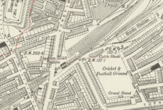
Junction Road railway station was a railway station in London (1872-1943). The station was opened by the Tottenham & Hampstead Junction Railway.

St Ann's Road railway station was opened by the Tottenham & Hampstead Junction Railway on 2 October 1882. It was at the corner of St Ann's Road and Seven Sisters Road in N15, in south west Tottenham, in what is now the London Borough of Haringey.

Pineapple Dance Studios' is a dance studio complex, performing arts school, and associated dancewear, clothing, and eyewear brand, based in London, England.

The London Borough of Camden is a London borough in Inner London, England. Camden Town Hall, on Euston Road, lies 1.4 mi (2.3 km) north of Charing Cross. The borough was established on 1 April 1965 and includes the former Central London borough of Holborn and St Pancras and Hampstead.

The Bull & Gate is a Grade II listed public house at 389 Kentish Town Road, Kentish Town, London.

The Town of Ramsgate public house is located at the centre of the ancient hamlet of Wapping in the London Borough of Tower Hamlets. It features in several books about London inns where it is rated as "a notable specimen of a waterman's tavern."
The Assembly House is a Grade II listed public house at 292–294 Kentish Town Road, Kentish Town, London.

The Trafalgar Tavern is a Grade II listed public house at Park Row, Greenwich, London, situated on the south bank of the River Thames, east of and adjacent to the Old Royal Naval College.

St John the Baptist, now the Christ Apostolic Church, is a grade II listed building at 23 Highgate Road, Kentish Town, London.

The Rose and Crown is a Grade II listed public house at 199 Stoke Newington Church Street, Stoke Newington, Hackney, London, N16 9ES.
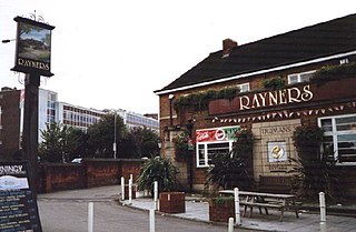
Rayners is a Grade II listed public house at 23 Village Way East, Rayners Lane, Harrow, London HA2 7LX.

Wanstead United Reformed Church is a United Reformed place of worship in Wanstead, east London.

The Dunboyne Road Estate previously known as the Fleet Road Estate is a Grade II-listed modernist estate, designed in Gospel Oak, London by Neave Brown in the late 1960s.

Kensington New Town is an area of housing in Kensington, London, which was developed in the early 19th century. It lies to the south of Kensington High Street and to the southwest of Kensington Gardens.

The Spread Eagle, on the corner of Albert Street and Parkway, is a Grade II listed pub in Camden Town in the London Borough of Camden, London, England.
![]() Media related to The Pineapple, Kentish Town at Wikimedia Commons
Media related to The Pineapple, Kentish Town at Wikimedia Commons
51°33′11″N0°08′23″W / 51.552983°N 0.13970090°W
| | This pub-related article is a stub. You can help Wikipedia by expanding it. |