
Stoke Newington is an area occupying the north-west part of the London Borough of Hackney in north-east London, England. It is five miles northeast of Charing Cross. The Manor of Stoke Newington gave its name to Stoke Newington the ancient parish.
Stoke Newington Church Street is a road in north London of the borough of Hackney. The road links Green Lanes (A105) in the west to Stoke Newington High Street, in the east. Stoke Newington is one of the villages swallowed by the growth of London in the 19th century, and Church Street retains some of this neighbourhood feel, with many restaurants, pubs, and independent (non-chain) shops.

Camden Passage is a picturesque pedestrian street, minutes from the Angel tube station off Upper Street in the London Borough of Islington. The passage is known for its antique shops, markets and its array of independent shops, cafes, and restaurants.

St Matthias' Church is a Grade-I listed Church of England parish church in Stoke Newington, north London, England. Since it opened it has been known for its distinctly ‘High Church’ forms of worship.

The Rose and Crown is a Grade II listed public house at London Road, Isleworth, London.
The Crown is a Grade II listed public house at High Street, Cowley, London.

The Crown is a Grade II listed public house at 116 Cloudesley Road, Islington, London.

The Angel and Crown is a Grade II listed public house at 58 St Martin's Lane, Covent Garden, London, WC2.

The Royal Oak is a Grade II listed public house at 73 Columbia Road, Bethnal Green, London, E2.
Arthur Edward Sewell (1872–1946) was an English architect, particularly known for the public houses he designed whilst working as the in-house architect for Truman's Brewery. His career peaked in the 1920s and 1930s, and at least five pubs that he designed in that period are now listed buildings with Historic England. In all, he designed around 50 pubs.

The Golden Heart is a Grade II listed public house in Spitalfields in the London Borough of Tower Hamlets, at 110 Commercial Street, London E1 6LZ. It was built in 1936 for Truman's Brewery, and designed by their in-house architect A. E. Sewell. In 2015, Historic England gave it a Grade II listing, saying that "its largely unaltered interior is one of the best surviving examples of Truman’s in-house style of the 1930s, illustrating many facets of an ‘improved’ pub".

The Angel is a Grade II listed public house at 697 Uxbridge Road, Hayes, Middlesex, UB4 8HX.

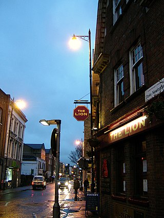
The Army and Navy is a Grade II listed public house at 1–3 Matthias Road, Stoke Newington, Hackney, London N16 8NT.
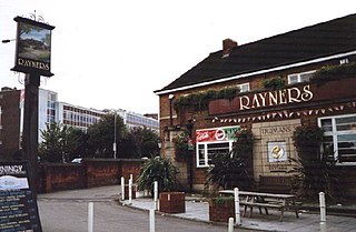
Rayners is a Grade II listed public house at 23 Village Way East, Rayners Lane, Harrow, London HA2 7LX.

The Rose and Crown is a public house in St Michael's Street, St Albans, Hertfordshire, England. The building appears to be eighteenth century and is listed Grade II with Historic England. It has been designated as an asset of community value.

The Owl and Pussycat is a pub at 34 Redchurch Street in the Shoreditch area of London.

The Rose and Crown is a former pub at 8 Stroudley Walk, Bow, London E3.

The Crown is a pub at 174 Richmond Road, Twickenham, London TW1. It is a Grade II listed building, dating back to the late 18th century.

St Mary, Stoke Newington is a parish church in Stoke Newington, London Borough of Hackney. Designed in the Gothic Revival version of the Decorated style by George Gilbert Scott and completed in 1858, it replaced a medieval and 16th century church, now an arts venue, and serves what remains of the ancient parish of Stoke Newington after other parishes were split from it in 1849, 1873, 1883 and 1892.
The Old Church is an arts venue in Stoke Newington, London Borough of Hackney, formerly the medieval and Tudor church of St Mary's Church or St Mary's Old Church. It is a Grade II* listed building.
