
The Bakerloo line is a London Underground line that runs from Harrow & Wealdstone in suburban north-west London to Elephant & Castle in south London, via the West End. Printed in brown on the Tube map, it serves 25 stations, 15 of which are underground, over 23.2 kilometres (14.4 mi). It runs partly on the surface and partly through deep-level tube tunnels.
Kensal Green is an area in north-west London and along with Queens Park forms the western part of Kilburn. It lies mainly in the London Borough of Brent, with a small part to the south within Kensington and Chelsea. Kensal Green is located on the Harrow Road, about 4.4 miles (7.1 km) miles from Charing Cross.
Paddington was a civil parish and metropolitan borough in London, England. It was an ancient parish in the county of Middlesex, governed by an administrative vestry. The parish was included in the area of responsibility of the Metropolitan Board of Works in 1855 and became part of the County of London in 1889. The parish of Paddington became a metropolitan borough in 1900, following the London Government Act 1899, with the parish vestry replaced by a borough council. In 1965 the borough was abolished and its former area became part of the City of Westminster in Greater London.

Ladbroke Grove is an area and a road in West London in the Royal Borough of Kensington and Chelsea, passing through Kensal Green and Notting Hill, running north–south between Harrow Road and Holland Park Avenue.

St Martin's Church in Bladon near Woodstock, Oxfordshire, England, is the Church of England parish church of Bladon-with-Woodstock. It is also the mother church of St Mary Magdalene at Woodstock, which was originally a chapel of ease. It is best known for the graves of the Spencer-Churchill family, including Sir Winston Churchill, in its churchyard.
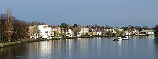
Strand-on-the-Green is one of Chiswick's four medieval villages, and a "particularly picturesque" riverside area in West London. It is a conservation area, with many "imposing" listed buildings beside the River Thames; a local landmark, the Kew Railway Bridge that crosses the River Thames and the Strand, is itself Grade II listed. Oliver's Island is just offshore.

The Harrow Road is an ancient route in North West London which runs from Paddington in a northwesterly direction towards Harrow. It is also the name given to the immediate surrounding area of Queens Park and Kensal Green, straddling the NW10, W10, W2 and W9 postcodes. With minor deviations in the 19th and 20th centuries, the route remains otherwise unaltered.

Kensal Town is a district located at the very north of the Royal Borough of Kensington and Chelsea where the Grand Union Canal forms the boundary with the City of Westminster. The area lies four miles north-west of Charing Cross and is part of the W postcode area. Kensal Town was an exclave of Chelsea from the middle ages, through to 1900.
Acton Green is a residential neighbourhood in Chiswick and the London Borough of Ealing, in West London, England. It is named for the nearby Acton Green common. It was once home to many small laundries and was accordingly known as "Soapsuds Island".

College Park is a small mainly residential neighbourhood in Kensal Green, to the north of the borough of Hammersmith and Fulham, London and is near Kensal Green station and Willesden Junction station. It borders the London Borough of Brent to the north and the Royal Borough of Kensington and Chelsea to the east. It is part of College Park & Old Oak wards of the United Kingdom.

The Town Crier is a public house located on the corner of City Road and Station Road, Chester, Cheshire, England. It stands opposite Chester General Station. It is recorded in the National Heritage List for England as a designated Grade II listed building.

The Old Pack Horse is a Grade II listed public house in a prominent position on the corner of Chiswick High Road and Acton Lane in Chiswick, London.
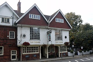
The block of three buildings containing The Tabard public house is a Grade II* listed structure in Chiswick, London. The block, with a row of seven gables in its roof, was designed by Norman Shaw in 1880 as part of the community focus of the Bedford Park garden suburb. The block contains the Bedford Park Stores, once a co-operative, and a house for the manager.
The Church of St Edward the Confessor is an anglican church in Romford, in the London Borough of Havering, England. It is part of the Diocese of Chelmsford. The building dates from 1849–50 and replaced an earlier church which was demolished in the mid-19th century. There has been a religious building on the site since the end of the 14th century. The current church was completed to a Victorian Gothic design by the English architect John Johnson. It was designated as a Grade II* listed building by English Heritage in 1952.
Arthur Edward Sewell (1872–1946) was an English architect, particularly known for the public houses he designed whilst working as the in-house architect for Truman's Brewery. His career peaked in the 1920s and 1930s, and at least five pubs that he designed in that period are now listed buildings with Historic England. In all, he designed around 50 pubs.

The Tally Ho is a public house in north Finchley, north London, under the management of the Stonegate Pub Company.

The Duke of Sussex, Acton Green is a public house, opened in 1898, in the northern Chiswick district of Acton Green. It is prominently situated on a corner facing the common. The Grade II listed building is "elaborately decorated" to a design by the pub architects Shoebridge & Rising.

The Power House, Chiswick is a former electricity generating station on Chiswick High Road and a Grade II listed building, completed in 1901. It provided power for the London United Electrical Tramway Company until 1917. The upper part of the building was converted for residential use in 1985, and the lower part for use as a recording studio in 1989.
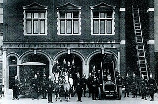
The Old Fire Station, Chiswick is an 1891 brick building with stone facings on Chiswick High Road. It served as a fire station until 1963, and has since been used as a restaurant.

Chiswick High Road is the principal shopping and dining street of Chiswick, a district in the west of London. It was part of the main Roman road running west out of London, and remained the main road until the 1950s when the A4 was built across Chiswick. By the 19th century the road through the village of Turnham Green had grand houses beside it. The road developed into a shopping centre when Chiswick became built up with new streets and housing to the north of Old Chiswick, late in the 19th century. There are several listed buildings including public houses, churches, and a former power station, built to supply electricity to the tram network.

