
The London Borough of Barnet is a suburban London borough in North West London. The borough was formed in 1965 from parts of the ceremonial counties of Middlesex and Hertfordshire. It forms part of Outer London and is the second largest London borough by population with 389,344 inhabitants, also making it the 17th largest district in England. The borough covers an area of 86.74 square kilometres (33 sq mi), the fourth highest of the 32 London boroughs, and has a population density of 45.8 people per hectare, which ranks it 25th.

Chipping Barnet or High Barnet is a suburban market town in north London, forming part of the London Borough of Barnet, England. It is a suburban development built around a 12th-century settlement, and is located 10+1⁄2 miles (17 km) north-northwest of Charing Cross, 3 miles (4.8 km) east from Borehamwood, 5.2 miles (8.4 km) west from Enfield and 3.2 miles (5.1 km) south from Potters Bar. Its population, including its localities East Barnet, New Barnet, Hadley Wood, Monken Hadley, Cockfosters and Arkley, was 47,359 in 2011.

Buntingford is a market town and civil parish in the district of East Hertfordshire and county of Hertfordshire in England. It lies next to the River Rib and is located on the historic Roman road, Ermine Street. As a result of its location, it grew mainly as a staging post with many coaching inns and has an 18th-century one-cell prison known as The Cage, by the ford at the end of Church Street. It has a population of 7879, as of the 2021 UK Census.

New Barnet is a neighbourhood on the north east side of the London Borough of Barnet. It is a largely residential North London suburb located east of Chipping Barnet, west of Cockfosters, south of the village of Monken Hadley and north of Oakleigh Park.

The coaching inn was a vital part of Europe's inland transport infrastructure until the development of the railway, providing a resting point (layover) for people and horses. The inn served the needs of travellers, for food, drink, and rest. The attached stables, staffed by hostlers, cared for the horses, including changing a tired team for a fresh one. Coaching inns were used by private travellers in their coaches, the public riding stagecoaches between one town and another, and the mail coach. Just as with roadhouses in other countries, although many survive, and some still offer overnight accommodation, in general coaching inns have lost their original function and now operate as ordinary pubs.

Chipping Barnet is a constituency created in 1974 represented in the House of Commons of the UK Parliament since 2005 by Theresa Villiers of the Conservative Party. Villiers was the Secretary of State for Northern Ireland from 2012 until 2016 under the leadership of Prime Minister David Cameron before she was dismissed when the incoming Prime Minister Theresa May took office. Boris Johnson appointed her as Secretary of State for Environment, Food and Rural Affairs in July 2019 before she was sacked in February 2020. It is part of the London Borough of Barnet.

Barnet was a local government district in south Hertfordshire from 1863 to 1965 around the town of Barnet.

East Barnet Valley was a local government district from 1863 to 1965 around the town of East Barnet. It was partly in the counties of Hertfordshire and Middlesex until 1889, when the Middlesex part was transferred to Hertfordshire. It was renamed East Barnet in 1935.

Shenley is a village and civil parish in Hertfordshire, England, between Barnet and St Albans. The village is located 14 miles from Central London. As of 2021, the population of the parish was 5,390; however, the parish stretches far beyond the village itself; it is the largest parish in Hertsmere and is very rural, including hamlets and farming settlements such as Dancers Hill, Green Street, Kitts End, Ridge, Saffron Green, Shenleybury, and the largest other settlement, South Mimms.

Barnet Gate is a hamlet on the northern edge of the London Borough of Barnet to the west of Arkley, in England. There was a settlement there during the Roman occupation of Britain and in the Anglo-Saxon period it was known as Grendeles Gatan after Grendel, the monster in the epic poem Beowulf. Manor courts were held there and brickmaking was an important local industry. It was on the edge of Southaw wood which was cleared when nearby Chipping Barnet was developed after which it was known as Barnet Gate. The Gate referred to no longer exists but was either a gate used to prevent cattle straying onto Barnet Common or a gate that marked the boundary between Hertfordshire and Middlesex.
Red Lion, Red Lions, Red Lyon, Red Lion Inn and variations, may refer to:

Arkley is an area of north London, England, within the London Borough of Barnet. It is located 10.6 miles (17.1 km) north-northwest of Charing Cross.

St John the Baptist Church is the Church of England parish church of Chipping Barnet, Greater London. It forms part of the Chipping Barnet Team Ministry, comprising St Mark's, Barnet Vale, St Peter's, Arkley and St Stephen's, Bell's Hill. It crowns the ascent up Barnet Hill, and stands at the junction of Wood Street and High Street. It is one of the few Anglican churches in Greater London to belong to the Diocese of St Albans.

The Mitre Inn is a public house at 58 High Street, Chipping Barnet, London. It was established by 1633 and is probably the oldest remaining of the town's once numerous coaching inns. It is a grade II listed building with Historic England and is currently styled "Ye Olde Mitre Inne".

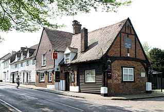
William Foster (1876-1940), was a British architect, the designer of many pubs for the Meux Brewery, including The Red Lion, Chipping Barnet.
The Holly Bush is a listed building, formerly a public house, on the High Street, Elstree, Hertfordshire, England. Elstree's High Street was formerly an important main road, the A5 which followed the course of the Roman road Watling Street.

Chipping is a hamlet in the civil parish of Buckland in the East Hertfordshire district, in the county of Hertfordshire, England. Situated along the A10 road, Chipping was an early, but unsuccessful attempt to create a market town at the crossing of the River Rib by Ermine Street. Situated in a valley, Chipping lies approximately two miles (3.2 km) north of Buntingford and six miles (9.7 km) south of Royston. Chipping is situated half a mile west of the prime meridian. Prior to 1750, Chipping was referred to as New Chipping, today this name is rarely used.


