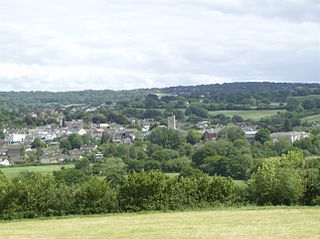
Bull and Mouth Inn

Last updated

Yard at the Bull and Mouth Inn, St Martin's le Grand, City of London, 1817, by George Shepherd Yard at the Bull and Mouth Inn, St Martin's le Grand, City of London, 1817. George Shepherd.png
Yard at the Bull and Mouth Inn, St Martin's le Grand, City of London, 1817, by George Shepherd
1875 Ordnance Survey map showing the location of the Queen's Hotel and the former Bull and Mouth Inn (italics) Bull and Mouth Inn, Ordnance Survey map 1875.jpg
1875 Ordnance Survey map showing the location of the Queen's Hotel and the former Bull and Mouth Inn (italics)
Sign of the Bull and Mouth Inn Bull and Mouth Inn sign.jpg
Sign of the Bull and Mouth Inn
The Old Bull & Mouth Inn, St. Martin's-Le-Grand, engraved by W. Watkins, after Thomas Hosmer Shepherd The Old Bull & Mouth Inn, St. Martin's Le Grand, Thomas H. Shepherd, W. Watkins.jpeg
The Old Bull & Mouth Inn, St. Martin's-Le-Grand, engraved by W. Watkins, after Thomas Hosmer Shepherd

The Bull and Mouth Inn was a coaching inn in the City of London that dated from before the Great Fire of London in 1666. It was located between Bull and Mouth Street (now Postman's Park) in the north and Angel Street in the south. It was once an important arrival and departure point for coaches from all over Britain, but particularly for the north of England and Scotland. It became the Queen's Hotel in 1830 but was demolished in 1887 or 1888 when new post office buildings were built in St Martin's Le Grand.

Contents

Origins

The original name of the inn was the Boulogne Mouth in reference to the town and harbor of Boulogne which was besieged by the English king Henry VIII in 1544–1546. [3] Over time, the name became the Bull and Mouth. [3] The inn building was destroyed in the Great Fire of London of 1666 but rebuilt. The street took its name from the inn and was first recorded on John Ogilby and William Morgan's Large Scale Map of the City As Rebuilt By 1676. [4]

Coach trade

The inn was an important arrival and departure point for coaches from all over England but particularly from the north and Scotland. [5] It was in close proximity to the General Post Office at St Martin's Le Grand, built 1829, which was the start of the mail coach route north along the Great North Road past the inn and along Aldersgate Street. In 1830, it was acquired by the coaching entrepreneur Edward Sherman and rebuilt as the Queen's Hotel [3] at a cost of £60,000. [6] The architect was James Savage. [4] [7] The hotel provided accommodation for passengers and underground stabling for 700 horses. [8] Walter Thornbury described it in 1878 as "much affected by Manchester men". [3]

It was painted by Thomas Hosmer Shepherd whose work was engraved by W. Watkins. [9]

Decline and legacy

The Post Office, St. Paul's Cathedral, and Bull & Mouth Inn, London in 1829. Engraved by G.J. Emblem after Thomas Allom. St Martin's Le grand looking south, inn on the right. The Post Office, St. Paul's Cathedral, and Bull & Mouth Inn, London in 1829 G J Emblem after Thomas Allom.jpg
The Post Office, St. Paul's Cathedral, and Bull & Mouth Inn, London in 1829. Engraved by G.J. Emblem after Thomas Allom. St Martin's Le grand looking south, inn on the right.

The coaching business began to decline after the arrival of the railways in the mid-nineteenth century and by 1875 an Ordnance Survey map shows the south side of the inn in Angel Street as a Great Northern Railway parcel office. [1] Walter Thornbury described it in 1878 as a luggage depot for the railway carriers Chaplin and Horne. [3] The hotel was demolished in 1887 or 1888 and new post office buildings at 1 St Martin's Le Grand erected on the site in 1890–1895. [4] A plaque on that building marks the approximate former location of the inn but in fact it was further west on the south side of Bull and Mouth Street, approximately where Postman's Park is now. [4]

A terracotta statuette of a bull inside a gaping mouth, above which is the bust of King Edward VI and the arms of Christ's Hospital to which the ground belonged,[ citation needed ] once graced the front of the Queen's Hotel but has since been removed to the garden of the Museum of London at nearby London Wall. [11] It bears the inscription:

Milo the Cretonian
An ox slew with his fist,
And ate it up at one meal,
Ye gods, what a glorious twist! [3]

probably in reference to Milo of Croton, [11] an ancient Greek wrestler and strongman sometimes depicted as carrying a bull on his shoulders. The inn's former sign, described by Historic England as "a striking Mannerist relief carving of a huge mouth swallowing an ox", [12] was transferred to the Guildhall Museum [13] and is now in the garden of the Museum of London. The museum also owns a wood and plaster sculpture of a bull above a grinning mouth, originally donated to the Guildhall Museum by Henry Cecil Raikes MP postmaster general, 1887. [2] [14]

Related Research Articles

Aldersgate is a Ward of the City of London, England, named after one of the northern gates in the London Wall which once enclosed the City.

<span class="mw-page-title-main">Coaching inn</span> Historical inn serving coach travellers

The coaching inn was a vital part of Europe's inland transport infrastructure until the development of the railway, providing a resting point (layover) for people and horses. The inn served the needs of travellers, for food, drink, and rest. The attached stables, staffed by hostlers, cared for the horses, including changing a tired team for a fresh one. Coaching inns were used by private travellers in their coaches, the public riding stagecoaches between one town and another, and the mail coach. Just as with roadhouses in other countries, although many survive, and some still offer overnight accommodation, in general coaching inns have lost their original function and now operate as ordinary pubs.

<span class="mw-page-title-main">Great North Road (Great Britain)</span> Historic road between London and Edinburgh

The Great North Road was the main highway between England and Scotland from medieval times until the 20th century. It became a coaching route used by mail coaches travelling between London, York and Edinburgh. The modern A1 mainly parallels the route of the Great North Road. Coaching inns, many of which survive, were staging posts providing accommodation, stabling for horses and replacement mounts. Nowadays virtually no surviving coaching inns can be seen while driving on the A1, because the modern route bypasses the towns in which the inns are found.

<span class="mw-page-title-main">Postman's Park</span> Park in central London

Postman's Park is a public garden in central London, a short distance north of St Paul's Cathedral. Bordered by Little Britain, Aldersgate Street, St. Martin's Le Grand, King Edward Street, and the site of the former headquarters of the General Post Office (GPO), it is one of the largest open spaces in the City of London.

<span class="mw-page-title-main">Bassishaw</span> Ward of the City of London

Bassishaw is a ward in the City of London. Small, it is bounded by wards: Coleman Street, east; Cheap, south; Cripplegate, north; Aldersgate, west.

<span class="mw-page-title-main">St Michael Queenhithe</span> Former church in London

St. Michael Queenhithe was a church in the City of London located in what is now Upper Thames Street. First recorded in the 12th century, the church was destroyed during the Great Fire of London in 1666. Rebuilt by the office of Sir Christopher Wren, it was demolished in 1876.

<span class="mw-page-title-main">Gresham Street</span> Street in the City of London

Gresham Street in the City of London is named after the English merchant and financier Thomas Gresham.

<span class="mw-page-title-main">St. Martin's Le Grand</span> Street in the City of London

St. Martin's Le Grand is a former liberty within the City of London, and is the name of a street north of Newgate Street and Cheapside and south of Aldersgate Street. It forms the southernmost section of the A1 road. For many years St. Martin's Le Grand was "often used as a synonym for the chief postal authorities, as Scotland Yard is used to designate the police", the headquarters of the General Post Office having been there from 1829-1984.

<span class="mw-page-title-main">St Leonard, Foster Lane</span> Church in London, England

St Leonard, Foster Lane, was a Church of England church dedicated to Leonard of Noblac on the west side of Foster Lane in the Aldersgate ward of the City of London. It was destroyed in the Great Fire of 1666 and not rebuilt.

<span class="mw-page-title-main">St Botolph's, Aldersgate</span> Church in London, England

St. Botolph without Aldersgate is a Church of England church in London dedicated to St. Botolph. It was built just outside Aldersgate, one of the gates on London's wall, in the City of London.

<span class="mw-page-title-main">St Olave's Church, Silver Street</span> Church in London, England

St Olave's Church, Silver Street was a church on the south side of Silver Street, off Wood Street in the Aldersgate ward of the City of London. It was dedicated to St Olaf, a Norwegian Christian ally of the English king Ethelred II. The church was destroyed by the Great Fire of London in 1666 and not rebuilt.
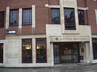
<span class="mw-page-title-main">Little Britain, London</span> Street in the City of London, England

<span class="mw-page-title-main">St John Zachary</span> Former church-site in London

St John Zachary was a church, first mentioned in official records in 1181, within the City of London, England, on the north side of Gresham Street, Aldersgate. Its vicar from 25 May 1424 to an unknown date was William Byngham, the founder of England's first teacher training college. It was destroyed in the Great Fire of London in 1666 and not rebuilt, with its parish being united with that of St Anne and St Agnes by Act of Parliament in 1670 –an arrangement that lasted until the 20th century. Its site is now a garden, first made by the fire watchers in 1941. Partial records survive at IGI.

<span class="mw-page-title-main">Trump Street</span> Street in the City of London

Trump Street is a street in the City of London that was originally known as Trumpadere Street, probably after the trumpet or horn makers who once worked there or in the adjacent Trump Alley. It was built after the Great Fire of London (1666) but completely destroyed by bombing during the Second World War and has since been entirely rebuilt.

<span class="mw-page-title-main">Swan with Two Necks, London</span> Former coaching inn in London

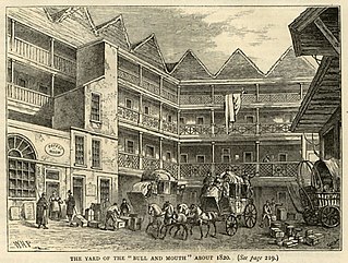
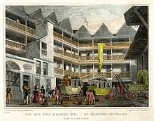
The Swan with Two Necks was a coaching inn in the City of London that, until the arrival of the railways, was one of the principal departure points for travel to the north of England from London. Its site was given over in the early 1860s to a goods and parcels depot for a firm of railway agents and carriers.

<span class="mw-page-title-main">Edward Sherman (coach proprietor)</span> English businessman (1776–1866)

Edward Sherman was a stagecoach proprietor from Berkshire who became the second largest operator of stagecoaches in England after William Chaplin.

<span class="mw-page-title-main">Bull and Mouth Street</span>

Bull and Mouth Street was a street in the City of London that ran between Edward Street and St Martin's Le Grand. On part of its site stands Postman's Park.

<span class="mw-page-title-main">King Edward Street, London</span>

King Edward Street is a street in the City of London that runs from Newgate Street in the south to Little Britain in the north. It is joined by Greyfriars Passage in the west and Angel Street in the east. Postman's Park is on its east side where Bull and Mouth Street once lay and joined King Edward Street.

<span class="mw-page-title-main">Angel Street, London</span> Street in the City of London

Angel Street, formerly known as Angel Alley, Angel Court, and Angell Street, is a street in the City of London that runs between King Edward Street in the west and St Martin's Le Grand in the east. Although dating back to at least 1542, no original buildings now remain due to the effects of the Great Fire of London, the London Blitz, and redevelopment.

<span class="mw-page-title-main">Coney Street</span> Street in York, England

Coney Street is a major shopping street in the city centre of York, in England. The street runs north-west from the junction of Spurriergate and Market Street, to St Helen's Square. New Street leads off the north-east side of the street, as does a snickelway leading to the Judges Court hotel, while several snickelways lead from the south-west side down to the River Ouse, including Blanshard's Lane, and paths leading to City Screen.

References

  1. 1 2 Ordnance Survey Map, 1875. Digimap. Retrieved 29 January 2018. (subscription required)
  2. 1 2 Inn sign. Museum of London. Retrieved 5 March 2018.
  3. 1 2 3 4 5 6 "Aldersgate Street and St Martin-le-Grand". British History Online. Retrieved 28 January 2018.
  4. 1 2 3 4 Brown's Yard, Angel Alley, Bishopsgate – Bull Court. British History Online. Retrieved 30 January 2018.
  5. "Bull and Mouth" in Christopher Hibbert; Ben Weinreb; John Keay; Julia Keay (2008). The London Encyclopaedia (3rd ed.). London: Pan Macmillan. p. 112. ISBN   978-0-230-73878-2.
  6. Hanson, Harry (1983). The Coaching Life . Manchester: Manchester University Press. p.  149. ISBN   978-0-7190-0930-3.
  7. Elmes, James (1831). A Topographical Dictionary of London and its Environs. London: Whittaker, Treacher and Arnot. p.  95 . Retrieved 19 June 2011.
  8. Allen, Louise. (2014) Stagecoach Travel . Oxford: Shire. p. 13. ISBN   978-0-7478-1537-2
  9. The Old Bull & Mouth Inn, St Martins-le-Grand: 19th century. Archived 31 January 2018 at the Wayback Machine Museum of London. Retrieved 30 January 2018.
  10. The Post Office, St. Paul's Cathedral, and Bull & Mouth Inn, London in 1829. Archived 2018-02-02 at the Wayback Machine Government Art Collection. Retrieved 1 February 2018.
  11. 1 2 Memorial: Bull and Mouth Inn – at Museum of London. London Remembers. Retrieved 29 January 2018.
  12. Historic England. "Former Library and Guildhall Museum (1064744)". National Heritage List for England . Retrieved 1 February 2018.
  13. Corporation of the City of London. (1908) Catalogue of the collection of London antiquities in the Guildhall Museum. 2nd edition. London. p. 252.
  14. Sign of the Bull and Mouth. Getty Images. Retrieved 1 February 2017.

51°30′59″N0°05′53″W / 51.5164°N 0.0980°W / 51.5164; -0.0980