The London Borough of Islington is a London borough which forms part of Inner London. Islington has an estimated population of 215,667. It was formed in 1965 under the London Government Act 1963, which simultaneously abolished the metropolitan boroughs of Islington and Finsbury.
Canonbury is a residential area of Islington in the London Borough of Islington, North London. It is roughly in the area between Essex Road, Upper Street and Cross Street and either side of St Paul's Road.
Highbury is a district in North London and part of the London Borough of Islington, in Greater London, that was owned by Ranulf, brother of Ilger, and included all the areas north and east of Canonbury and Holloway Roads.

Holloway is an inner-city district of the London Borough of Islington, 3.3 miles (5.3 km) north of Charing Cross, which follows the line of the Holloway Road (A1). At the centre of Holloway is the Nag's Head commercial area which sits between the more residential Upper Holloway and Lower Holloway neighbourhoods. Holloway has a multicultural population. It is the home of Arsenal F.C., and was once home to the largest women's prison in Europe, Holloway Prison, until 2016. Prior to 1965, Holloway was in the historic county of Middlesex.

Islington is a district in the north of Greater London, England, and part of the London Borough of Islington. It is a mainly residential district of Inner London, extending from Islington's High Street to Highbury Fields, encompassing the area around the busy High Street, Upper Street, Essex Road, and Southgate Road to the east.
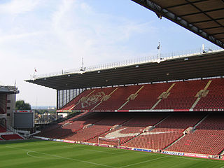
Arsenal Stadium was a football stadium in Highbury, London, which was the home of Arsenal Football Club between 6 September 1913 and 7 May 2006. It was popularly known as "Highbury" due to its location and was given the affectionate nickname of the "Home of Football".

Belgravia is a district in Central London, covering parts of the areas of both the City of Westminster and the Royal Borough of Kensington and Chelsea.

Holloway Road is a road in London, 3 kilometres (1.9 mi) in length. It is one of the main shopping streets in North London, and carries the A1 road as it passes through Holloway, in the London Borough of Islington. The road starts in Archway, near Archway Underground station, then heads south-east, past Upper Holloway railway station, Whittington Park, past the North London campus of London Metropolitan University near Nag's Head, past Holloway Road Underground station, and the main campus of the university, and then becomes Highbury Corner, near Highbury & Islington station.

The New North Road is a road in northern central London, forming part of a link road from the A1 at Highbury into the City of London at Moorgate. It is 0.8 miles (1.3 km) in length and is part of the A1200. This link road consists of Canonbury Road and New North Road, before several smaller sections to the south leading into the city.

Liverpool Road is a street in Islington, North London. It covers a distance of 1+1⁄4 miles (2.0 km) between Islington High Street and Holloway Road, running roughly parallel to Upper Street through the area of Barnsbury. It contains several attractive terraces of Georgian houses and Victorian villas, many of which are listed buildings. There are a number of pubs, small businesses and restaurants along its route, as well as some secluded garden squares. The vast majority of the street is residential, with a bustling shopping and business area at the southern, Angel, end.
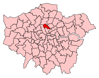
Islington North is a constituency in Greater London represented in the House of Commons of the UK Parliament since 1983 by Jeremy Corbyn, who was Leader of the Labour Party and Leader of the Opposition from 2015 to 2020.

Upper Street is the main street of the Islington district of inner north London, and carries the A1 road. It begins at the junction of the A1 and Liverpool Road, continuing on from Islington High Street which runs from the crossroads at Pentonville Road/City Road and runs roughly northwards from outside the main entrance to Angel Underground station, then past the Business Design Centre, then splits at Islington Green, then past The Screen On The Green cinema, past Islington Town Hall, ending at Highbury & Islington tube station on Highbury corner, where the A1 carries on as Holloway Road.

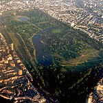
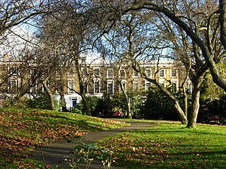
The London Borough of Islington is short of large parks and open spaces, given its status in recent decades as a desirable place of residence. In fact, Islington has the lowest ratio of open space to built-up areas of any London borough. The largest continuous open space in the borough, at 11.75 hectares, is Highbury Fields.

The Manor Ground located in Plumstead, south east London was a football stadium. This arena was the home of football club Royal Arsenal, which was later named Woolwich Arsenal, and as such came to be known as Arsenal F.C.

London Buses route 277 is a Transport for London contracted bus route in London, England. Running between Crossharbour and Dalston Junction, it is operated by Stagecoach London.

The Burma Railway Memorial is a memorial near Mornington Crescent tube station, in Camden High Street, London, to the thousands of British civilian and military prisoners of war in the Far East who died of disease, starvation or maltreatment while building the Burma Railway during the Second World War.
Thornhill Square together with the adjacent Thornhill Crescent form a garden square in the Barnsbury district of Islington, North London. It is bounded by Victorian terraced houses, all of which are listed buildings. The central public gardens contain flower beds, mature trees, and a children's play area, and the Crescent gardens surround the Victorian Church of St Andrew.

Wilmington Square is a garden square in the Clerkenwell district of Islington, North London. It is bounded by Regency and Victorian terraces, most of which are listed buildings. The central public gardens contain flower beds and mature trees, a pavilion or shelter, and a water fountain.