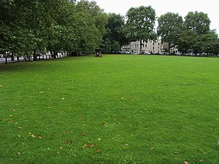
Wormwood Scrubs, known locally as The Scrubs, is an open space in Old Oak Common located in the north-eastern corner of the London Borough of Hammersmith and Fulham in west London. It is the largest open space in the borough, at 67 hectares, and one of the largest areas of common in London. The eastern part, known as Little Wormwood Scrubs, is cut off by Scrubs Lane and the West London line railway. It has been an open public space since the Wormwood Scrubs Act 1879.

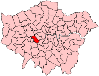
The London Borough of Hammersmith and Fulham is a London borough in West London and which also forms part of Inner London. The borough was formed in 1965 as the London Borough of Hammersmith from the merger of the former Metropolitan Boroughs of Fulham and Hammersmith. The name was changed to Hammersmith and Fulham in 1979. The borough borders Brent to the north, the Royal Borough of Kensington and Chelsea to the east, Wandsworth to the south, Richmond upon Thames to the south west, and Hounslow and Ealing to the west.

Fulham is an ancient and historic settlement within the London Borough of Hammersmith & Fulham in West London, England, 3.6 miles (5.8 km) southwest of Charing Cross. It lies in a loop on the north bank of the River Thames, bordering Hammersmith, Kensington and Chelsea, with which it shares the area known as West Brompton. Over the Thames Fulham faces Wandsworth, Putney, the London Wetland Centre in Barnes in the London Borough of Richmond upon Thames.
The Metropolitan Borough of Fulham was a metropolitan borough in the County of London between 1900 and 1965, when it was merged with the Metropolitan Borough of Hammersmith to form the London Borough of Hammersmith and Fulham. It was a riverside borough, and comprised the many centuries-long definition of Fulham so included parts often considered of independent character today Walham Green, Parsons Green, Hurlingham, Sands End and that part of Chelsea Harbour west of Counter's Creek. The SW6 postal district approximately follows this as does the direct, though less empowered, predecessor Fulham civil parish.

King's Road or Kings Road is a major street stretching through Chelsea and Fulham, both in west London, England. It is associated with 1960s style and with fashion figures such as Mary Quant and Vivienne Westwood. Sir Oswald Mosley's Blackshirt movement had a barracks on the street in the 1930s.
Wood Lane is a street in London. It runs north from Shepherd's Bush, under the Westway (A40) past Wormwood Scrubs where it meets Scrubs Lane. The road is wholly in the London Borough of Hammersmith and Fulham. It is probably best known as the former home of the BBC Television Centre, also BBC White City and formerly BBC Woodlands the offices of BBC Worldwide.
Eel Brook Common is common land in the London Borough of Hammersmith and Fulham, close to Fulham Broadway, with its south-eastern boundary along New King's Road. According to the Fulham Society, the name actually is a derivative of 'hill brook common' - which relates to Musgrave Crescent, which is raised much higher than the surrounding land. It is believed that this is artificial and it probably was originally a Bronze Age mound - either a raised piece of ground to defend against attackers, or as a burial mound. When you leave Eel Brook Common from the north side, you go up a steep ramp - up onto Musgrave Crescent. It is within the Hammersmith and Fulham Conservation Area of Parsons Green.
Hammersmith and Fulham was a constituency represented in the House of Commons of the Parliament of the United Kingdom. It elected one Member of Parliament (MP) by the first past the post system of election. The constituency was abolished at the 2010 general election with its wards being split between two new constituencies of Chelsea and Fulham & Hammersmith.

Parsons Green is a mainly residential district in the London Borough of Hammersmith and Fulham. The Green itself, which is roughly triangular, is bounded on two of its three sides by the New King's Road section of the King's Road, A308 road and Parsons Green Lane. The wider neighbourhood is bounded by the Harwood and Wandsworth Bridge Roads, A217 road to the east and Munster Road to the west, while the Fulham Road, A3219 road may be said to define its northern boundary. Its southern boundary is less clearly defined as it merges quickly and imperceptibly with the Sulivan Court Estate and Hurlingham.

West Kensington, formerly North End, is an area in the ancient parish of Fulham, in the London Borough of Hammersmith and Fulham, England, 3.4 miles (5.5 km) west of Charing Cross. It covers most of the London postal area of W14, including the area around Barons Court tube station, and is defined as the area between Lillie Road and Hammersmith Road to the west, Fulham Palace Road to the south, Hammersmith to the north and West Brompton and Earl's Court to the east. The area is bisected by the major London artery the A4, locally known as the Talgarth Road. Its main local thoroughfare is the North End Road.

Chelsea and Fulham is a constituency in Greater London represented in the House of Commons of the UK Parliament by Ben Coleman of the Labour Party.
The Greater London Built-up Area, or Greater London Urban Area, is a conurbation in south-east England that constitutes the continuous urban sprawl of London, and includes surrounding adjacent urban towns as defined by the Office for National Statistics. It is the largest urban area in the United Kingdom with a population of 9,787,426 in 2011.

Ravenscourt Park or RCP is an 8.3 hectares public park and garden located in the London Borough of Hammersmith and Fulham, England. It is one of the Borough's flagship parks, having won a Green Flag Award. Stamford Brook and Ravenscourt Park tube stations are close by.

Walham Green is the historic name of an English village, now part of inner London, in the parish of Fulham in the County of Middlesex. It was located between the hamlet of North End to the north, and Parsons Green to the south. To the east it was bounded by Counter's Creek, the historical boundary with the parish of Chelsea, and to the south-east is Sands End.

Shepherd's Bush Green is an approximately 8-acre (3.2 ha) triangular area of open grass surrounded by trees and roads with shops in Shepherd's Bush, an area of west London which takes its name from the Green. The Green is also a ward of the London Borough of Hammersmith and Fulham. The population of the ward at the 2011 Census was 12,175.

South Park is a 7.9 hectare park in the London Borough of Hammersmith and Fulham. South Park contains a public cricket pitch, tennis courts, football pitches, netball and basketball courts. In addition there is a large children's playground fenced off from the main park and a 1 km perimeter walk used by runners, walkers, dogs and their owners. Many people enjoy South Park for its unique trees and well maintained gardens. A nursery for 2-5 year olds operates out of the cricket pavilion.

Brackenbury Village is a residential district of Hammersmith in the London Borough of Hammersmith and Fulham, forming the area between Goldhawk Road, King Street, Hammersmith Grove and Ravenscourt Park. The area was given its name by estate agents and named after Brackenbury Road, in which there is a small parade of shops that form the core of the self-styled village. Victorian terraced homes characterise the housing stock.

St Paul's is a Grade II* listed Anglican church on Queen Caroline Street, Hammersmith, London.

King Street, Hammersmith is the main shopping street in Hammersmith, London. It runs west–east, and forms part of the A315, and is the eastern continuation of Chiswick High Road, where it meets Goldhawk Road, close to Stamford Brook tube station. At the eastern end it meets Hammersmith Broadway and continues east as Hammersmith Road where it forms a crossroads with the A219, the Shepherd's Bush Road running northwards, and the Fulham Palace Road running south.

Lillie Bridge is a road bridge that links Old Brompton Road in the Royal Borough of Kensington and Chelsea with Lillie Road in the London Borough of Hammersmith & Fulham. It crosses two railways: the West London Line on the London Overground and the Wimbledon branch of the London Underground at West Brompton station.