Leyton Marsh

Last updated

Horse grazing in open land near Marsh Lane LammasLand-485.JPG
Horse grazing in open land near Marsh Lane

Leyton Marsh is an open space in the Lower Lea Valley, located in Leyton in the London Borough of Waltham Forest.

Contents

Geography

Playgrounds near the Seymour Road entrance LammasLand-482.JPG
Playgrounds near the Seymour Road entrance

The marsh is bordered by the Walthamstow Marshes to the north, and by Coppermill Fields, the Lee Navigation and the River Lee Flood Relief Channel. Much of the original area has been taken over for other uses. The remaining open land is split into two distinct areas:

Other areas which were historically part of Leyton Marshes are now put to other uses:

There are proposals to redevelop the Ice Centre, improving facilities but at the expense of public open space. [3]

Lammas Lane, despite historic associations, is buried in an industrial estate alongside the railway. [4]

History

Plan of Lammas lands, Leyton Urban District Council Act 1904 Leyton Urban District Council Act 1904 map.jpg
Plan of Lammas lands, Leyton Urban District Council Act 1904

Leyton Marsh was originally more extensive open marsh, historically drained by means of open drainage ditches. The marsh is former Lammas Land: the land was divided into strips, which were cultivated to grow hay for winter feed. Parishioners had ancient rights to graze cattle and horses between 1 August (after the hay harvest) and 25 March. [6] [7]

In the 19th century the marsh was polluted by sewage from the extensive new residential developments in Walthamstow and Leyton.

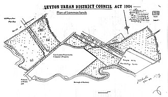
By the 19th century the character of the marsh changed. Many acres were bought and built on by railway, water and gas companies. In the early 1890s the East London Waterworks Company erected fences, which angered local people. On Lammas Day in 1892, a large demonstration took place on the marsh and the fences were taken down. The locals set up the Leyton Lammas Lands Defence Committee and successfully challenged the water company in court. This led to the Leyton Urban District Council Act 1904, which provided that the marsh would be kept as an open space, in return for local people giving up Lammas rights. [5] [6] The fields at Marsh Lane did not come under this agreement and remain as Lammas land. [8]

During World War II, a V-2 rocket landed and exploded on the marsh; the crater is still visible seven decades later [9] (Despite the account given in the reference, the V2 concerned fell a little to the north on the adjacent Walthamstow Marsh: see Bomb Crater Pond (Walthamstow)). After the war, the marsh was used to dump rubble from The Blitz.

In 1971, the Lee Valley Regional Park Authority acquired much of the land by compulsory purchase. It acquired the Essex Filter Beds in 1986 (now the WaterWorks Nature Reserve) and the Middlesex Filter Beds in 1988 (now the Middlesex Filter Beds Nature Reserve). Both of these are on the south side of Lea Bridge Road and were formerly part of the marsh.

Recent history and current use

Part of Leyton Marsh, restored after use for the 2012 Olympics Leyton Marsh.jpg
Part of Leyton Marsh, restored after use for the 2012 Olympics

The New Lammas Lands Defence Committee, a revival of the earlier organisation, is currently active in promoting, and on occasion defending, the public use of the marsh. Events include organised walks, with an annual highlight on 13 March: beating the bounds, an ancient ritual defining the boundaries of the land where grazing rights were enjoyed.

Parts of Leyton Marshes were used for the 2012 London Olympic and Paralympic Games, despite some local opposition. A temporary basketball training venue was built on Porter's Field Meadow for the games, which was opposed by members of Save Lea Marshes. [10] [11] [12] The venue was dismantled after the Paralympic Games, the Olympic Delivery Authority being required to return the open space to its original state. In addition, on the request of the local user group, the Lee Valley Regional Park Authority committed to spending £65,000 on improving Leyton Marsh, including pathways and seating, as well as introducing habitats to attract existing and new species of wildlife into the area.

Related Research Articles

<span class="mw-page-title-main">Leyton</span> Town in east London, England

Leyton is a town in east London, England, within the London Borough of Waltham Forest. It borders Walthamstow to the north, Leytonstone to the east, and Stratford to the south, with Clapton, Hackney Wick and Homerton, across the River Lea, to the west. The area includes New Spitalfields Market, Leyton Orient Football Club, as well as part of the Queen Elizabeth Olympic Park. The town consists largely of terraced houses built between 1870 and 1910, interspersed with some modern housing estates. It is 6.2 miles (10 km) north-east of Charing Cross.

<span class="mw-page-title-main">Walthamstow</span> Town in East London

Walthamstow is a large town in the London Borough of Waltham Forest, around 7+12 miles (12 km) northeast of Central London. Traditionally part of Essex and now within Greater London for ceremonial and administrative purposes, the town borders Chingford to the north, Snaresbrook and South Woodford to the east, Leyton and Leytonstone to the south, and Tottenham to the west. At the 2011 census, the town had a population of approximately 109,424.

<span class="mw-page-title-main">London Borough of Waltham Forest</span> London borough in United Kingdom

The London Borough of Waltham Forest is a London borough in north-east London, England. Its population is estimated to be 276,983 in 2019. It borders five other London boroughs: Enfield to the north-west, Haringey to the west, Hackney to the south-west, Newham to the south-east and Redbridge to the east, as well as the non-metropolitan county of Essex to the north.

<span class="mw-page-title-main">River Lea</span> River in the south east of England

The River Lea is in South East England. It originates in Bedfordshire, in the Chiltern Hills, and flows southeast through Hertfordshire, along the Essex border and into Greater London, to meet the River Thames at Bow Creek. It is one of the largest rivers in London and the easternmost major tributary of the Thames.

<span class="mw-page-title-main">Lee Navigation</span> Canalised river in Hertfordshire and London, England

The Lee Navigation is a canalised river incorporating the River Lea. It flows from Hertford Castle Weir to the River Thames at Bow Creek; its first lock is Hertford Lock and its last Bow Locks.

<span class="mw-page-title-main">Lea Bridge</span> Human settlement in England

Lea Bridge is a district in the London Borough of Hackney and the London Borough of Waltham Forest in London, England. It lies 7 miles (11.3 km) northeast of Charing Cross.

<span class="mw-page-title-main">Hackney Marshes</span> Open space in London

Hackney Marshes is an area of open space in London's Lower Lea Valley, lying on the western bank of the River Lea. It takes its name from its position on the eastern boundary of Hackney, the principal part of the London Borough of Hackney, and from its origin as an area of true marsh.

<span class="mw-page-title-main">Lee Valley Park</span> Linear park along the Lee Valley

Lee Valley Regional Park is a 10,000-acre (40 km2) 26 miles (42 km) long linear park, much of it green spaces, running through the northeast of Greater London, Essex and Hertfordshire from the River Thames to Ware, through areas such as Stratford, Clapton, Tottenham, Enfield, Walthamstow, Waltham Abbey, Cheshunt, Broxbourne and Hoddesdon in an area generally known as the Lea Valley. Greater London's largest park, Lee Valley Park is more than four times the size of Richmond Park, extending beyond Greater London's borders into the neighbouring counties of Hertfordshire and Essex.

<span class="mw-page-title-main">Walthamstow Marshes</span> Marsh in London, England, UK

Walthamstow Marshes, is a 36.7-hectare (91-acre) biological Site of Special Scientific Interest in Walthamstow in the London Borough of Waltham Forest. It was once an area of lammas land – common land used for growing crops and grazing cattle.

<span class="mw-page-title-main">Whipps Cross</span> Human settlement in England

Whipps Cross is an area of the districts of Leytonstone and Walthamstow in the London Borough of Waltham Forest in London, England. It is most famous for Whipps Cross University Hospital.

The Lea Valley, the valley of the River Lea, has been used as a transport corridor, a source of sand and gravel, an industrial area, a water supply for London, and a recreational area. The London 2012 Summer Olympics were based in Stratford, in the Lower Lea Valley. It is important for London's water supply, as the source of the water transported by the New River aqueduct, but also as the location for the Lee Valley Reservoir Chain, stretching from Enfield through Tottenham and Walthamstow.

<span class="mw-page-title-main">Lea Bridge Road</span>

Lea Bridge Road is a major through route in east London, across the Lea Valley from Clapton to Whipps Cross in Leyton. It forms part of the A104 road.

<span class="mw-page-title-main">Lea Valley Walk</span> Long-distance footpath in South East England

The Lea Valley Walk is a 50-mile (80 km) long-distance path located between Leagrave, the source of the River Lea near Luton, and the Thames, at Limehouse Basin, Limehouse, east London. From its source much of the walk is rural. At Hertford the path follows the towpath of the River Lee Navigation, and it becomes increasingly urbanised as it approaches London. The walk was opened in 1993 and is waymarked throughout using a swan logo.

<span class="mw-page-title-main">Lee Flood Relief Channel</span>

The Lee Flood Relief Channel (FRC) is located in the Lea Valley and flows between Ware, Hertfordshire, and Stratford, east London. Work started on the channel in 1947 following major flooding and it was fully operational by 1976. The channel incorporates existing watercourses, lakes, and new channels. Water from the channel feeds the Lee Valley Reservoir Chain.

<span class="mw-page-title-main">Lee Valley Reservoir Chain</span> Chain of 13 reservoirs supplying London

The Lee Valley Reservoir Chain is located in the Lee Valley, and comprises 13 reservoirs that supply drinking water to London.

<span class="mw-page-title-main">Dagenham Brook</span> Minor tributary of the River Lea in east London

Dagenham Brook is a minor tributary of the River Lea located in the London Borough of Waltham Forest, and the traditional eastern limit of Leyton Marshes.

<span class="mw-page-title-main">Pond Lane Flood Gates</span>

Pond Lane Flood Gates is a redundant flood defence structure, located near Lea Bridge Road on the River Lee Navigation in the London Borough of Hackney, England.

<span class="mw-page-title-main">Springfield Park (London)</span>

Springfield Park is a park in Upper Clapton in the London Borough of Hackney.

<span class="mw-page-title-main">Walthamstow Wetlands</span> Urban nature reserve in Walthamstow, East London

Walthamstow Wetlands is a 211-hectare nature reserve in Walthamstow, east London, adjacent to the historic Essex-Middlesex border on the River Lea. It is focused on the Walthamstow Reservoirs, built by the East London Waterworks Company between 1853 and 1904 as part of the Lee Valley Reservoir Chain. The site is one of the largest urban wetland nature reserves in Europe and is particularly important for wildlife due to its position within the Lee Valley. It serves as a byway for migrating, wintering and breeding birds. Visitors can freely access the site's natural, industrial and social heritage in one of the capital's most densely populated urban areas.

<span class="mw-page-title-main">Clapton, London</span> Human settlement in England

Clapton is a district of East London, England, in the London Borough of Hackney.

References

  1. "Countryside Live - Lea Valley". Archived from the original on 2 August 2011. Retrieved 24 July 2011.
  2. Waltham Forest pamphlet on Leyton Jubilee Park
  3. Newspaper article on progress of the proposal https://www.hackneycitizen.co.uk/2020/10/09/campaigners-warn-environmental-impact-new-lea-valley-ice-centre-approved/
  4. Google map
  5. 1 2 section of Leyton Urban District Council Act 1904
  6. 1 2 British History online (fn.194 & fn.55) Retrieved 12 December 2007
  7. New Lammas Lands Defence Committee Retrieved 12 December 2007
  8. Lammas lands Retrieved 18 March 2008
  9. "London V2 Rocket Sites...Mapped". 12 January 2009.
  10. "London 2012: Occupy protesters halt Leyton Marsh work". BBC News. 28 March 2012. Retrieved 30 April 2013.
  11. Parkinson, Jason N; Jess Hurd (21 December 2012). "Save Leyton Marsh protester threatened with £335,000 eviction costs - video". The Guardian. Retrieved 30 April 2013.
  12. Leyeon Marsh campaign

Coordinates: 51°34′1.48″N0°2′43.61″W / 51.5670778°N 0.0454472°W / 51.5670778; -0.0454472