
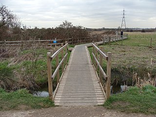
Dagenham Brook is a minor tributary of the River Lea located in the London Borough of Waltham Forest, and the traditional eastern limit of Leyton Marshes. [1]
Dagenham Brook is a minor tributary of the River Lea located in the London Borough of Waltham Forest, and the traditional eastern limit of Leyton Marshes. [1]

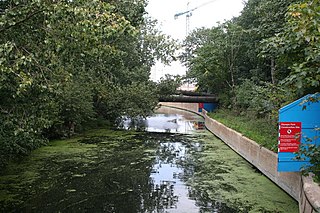
The brook emerges from the old route of the River Lea at the northeast corner of Lockwood Reservoir [2] and flows south, running alongside the members of the Lee Valley Reservoir Chain until it crosses the Lea Valley lines railway, just to the west of St. James Street railway station in Walthamstow. [2] For this section of its route it forms a part of the Lee Flood Relief Channel, constructed between 1947 and 1976. The flood channel turns west on the south side of the railway and the brook's original course splits off, continuing southeast under Lea Bridge Road until going underground at the site of the former Leyton Sewage Works. [lower-alpha 1] [2] It briefly returns to the surface for a short stretch by Ruckholt Road, at which point it vanishes underground to eventually join the Waterworks River. [2] In the 19th century the brook also, at that point, joined a network of artificial channels that ran through the marshy Temple Mills area. [2]
The brook has been designated a site of Local Nature Conservation Importance. Different species of birds that can be spotted along it include the kingfisher. Mammals including foxes and rabbits have also been recorded.

Leyton is a town in East London, England, within the London Borough of Waltham Forest. It borders Walthamstow to the north, Leytonstone to the east, and Stratford to the south, with Clapton, Hackney Wick and Homerton, across the River Lea, to the west. The area includes New Spitalfields Market, Leyton Orient Football Club, as well as part of the Queen Elizabeth Olympic Park. The town consists largely of terraced houses built between 1870 and 1910, interspersed with some modern housing estates. It is 6.2 miles (10 km) north-east of Charing Cross.
The London Borough of Waltham Forest is an outer London borough formed in 1965 from the merger of the municipal boroughs of Leyton, Walthamstow and Chingford.
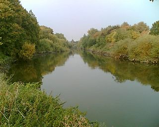
The River Lea is in the East of England and Greater London. It originates in Bedfordshire, in the Chiltern Hills, and flows southeast through Hertfordshire, along the Essex border and into Greater London, to meet the River Thames at Bow Creek. It is one of the largest rivers in London and the easternmost major tributary of the Thames.

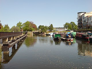
Lea Bridge is a district in the London Borough of Hackney and the London Borough of Waltham Forest in London, England. It lies 7 miles (11.3 km) northeast of Charing Cross.
Hackney Marshes is an area of open space in London's Lower Lea Valley, lying on the western bank of the River Lea. It takes its name from its position on the eastern boundary of Hackney, the principal part of the London Borough of Hackney, and from its origin as an area of true marsh.
Bow Back Rivers or Stratford Back Rivers is a complex of waterways between Bow and Stratford in east London, England, which connect the River Lea to the River Thames. Starting in the twelfth century, works were carried out to drain Stratford Marshes and several of the waterways were constructed to power watermills. Bow Creek provided the final outfall to the Thames, and the other channels were called Abbey Creek, Channelsea River, City Mill River, Prescott Channel, Pudding Mill River, Saint Thomas Creek, Three Mills Back River, Three Mills Wall River and Waterworks River.
Lee Valley Regional Park is a 10,000-acre (40 km2) 26 miles (42 km) long linear park, much of it green spaces, running through the northeast of Greater London, Essex and Hertfordshire. The park follows the course of the River Lea (Lee) along the Lea Valley from Ware in Hertfordshire through Essex and the north east of Greater London, through the Queen Elizabeth Olympic Park to East India Docks Basin on the River Thames. The park is managed by Lee Valley Regional Park Authority and is made up of a diverse mix of countryside areas, urban green spaces, heritage sites, country parks, nature reserves and lakes and riverside trails, as well as leading sports centres covering an area of over 10,000 acres (40 km2). It is crossed by a number of roads and railways.
Walthamstow Marshes, is a 36.7-hectare (91-acre) biological Site of Special Scientific Interest in Walthamstow in the London Borough of Waltham Forest. It was once an area of lammas land – common land used for growing crops and grazing cattle.
Temple Mills is a district located on the boundary of the London boroughs of Newham and Waltham Forest, with a small part also in Hackney in east London.
The Lea Valley, the valley of the River Lea, has been used as a transport corridor, a source of sand and gravel, an industrial area, a water supply for London, and a recreational area. The London 2012 Summer Olympics were based in Stratford, in the Lower Lea Valley. It is important for London's water supply, as the source of the water transported by the New River aqueduct, but also as the location for the Lee Valley Reservoir Chain, stretching from Enfield through Tottenham and Walthamstow.

Lea Bridge Road is a major through route in east London, across the Lea Valley from Clapton to Whipps Cross in Leyton. It forms part of the A104 road.

Pymmes Brook is located in North London and named after William Pymme, a local land owner. It is a minor tributary of the River Lea. The brook mostly flows through urban areas and is particularly prone to flooding in its lower reaches. To alleviate the problem the brook has been culverted in many areas. Part of it is a Site of Borough Importance for Nature Conservation, Grade II.

Salmons Brook is a minor tributary of the River Lea, located in the London Borough of Enfield.

National Cycle Route 1 is a route of the United Kingdom National Cycle Network, running from Dover to Tain. The 1,264 mi-long (2,034-kilometre) cycle-path is located in the United Kingdom.

The Lea Valley Walk is a 50-mile (80 km) long-distance path located between Leagrave, the source of the River Lea near Luton, and the Thames, at Limehouse Basin, Limehouse, east London. From its source much of the walk is rural. At Hertford the path follows the towpath of the River Lee Navigation, and it becomes increasingly urbanised as it approaches London. The walk was opened in 1993 and is waymarked throughout using a swan logo.
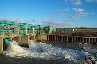
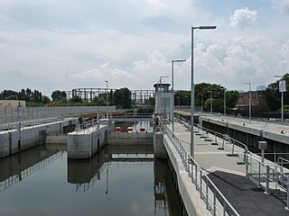
The Lee Flood Relief Channel (FRC) is located in the Lea Valley and flows between Ware, Hertfordshire, and Stratford, east London. Work started on the channel in 1947 following major flooding and it was fully operational by 1976. The channel incorporates existing watercourses, lakes, and new channels. Water from the channel feeds the Lee Valley Reservoir Chain.

Old Ford Lock is a paired lock and weir on the River Lee Navigation, in the London Borough of Tower Hamlets, England. It is at Fish Island in Old Ford and takes its name from the natural ford which used to cross the River Lea.

The Lee Valley Reservoir Chain is located in the Lee Valley, and comprises 13 reservoirs that supply drinking water to London.

Leyton Marsh is an open space in the Lower Lea Valley, located in Leyton in the London Borough of Waltham Forest.
The Old River Lea is the former natural channel of the River Lea below Lea Bridge, in the London Borough of Hackney. The Old River forms a large meander from the Middlesex Filter Beds Weir to rejoin the main channel of the River Lee Navigation below Old Ford Lock, just west of the 2012 Olympic stadium.