
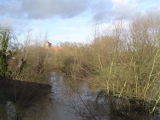
The River Eden is a tributary of the River Medway in south east England. It rises at the foot of the North Downs escarpment near Titsey in Surrey and runs initially southwards through Oxted before turning eastwards to enter Kent. After flowing through Edenbridge and passing Hever Castle, the Eden meets the Medway at Penshurst.
The River Thame is a river in Southern England. A tributary of the River Thames, the river runs generally south-westward for about 40 mi (64 km) from its source above the Buckinghamshire town of Aylesbury to the Thames in south-east Oxfordshire.
This article lists the islands in the River Thames, or at the mouth of a tributary, in England. It excludes human-made islands built as part of the building of forty-five two-gate locks which each accompany a weir, and islets subordinate to and forming part of the overall shape of another. The suffix -ey is common across England and Scotland and cognate with ait and meaning island, a term – as ait or eyot – unusually well-preserved on the Thames. A small minority of list entries are referred to as Island, Ait or Eyot and are vestiges, separated by a depression in the land or high-water-level gully.

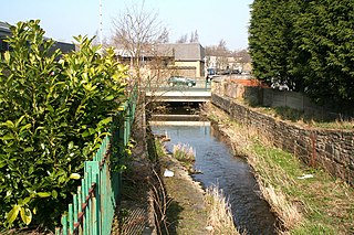
Kearsney is a village in Kent, England. At one time it would have been called a hamlet, there being no church there. The population of the village is included in the civil parish of Temple Ewell.

The River Evenlode is a river in England which is a tributary of the Thames in Oxfordshire. It rises near Moreton-in-Marsh, Gloucestershire in the Cotswold Hills and flows south-east passing near Stow-on-the-Wold, Charlbury, Bladon, and Cassington, and its valley provides the route of the southern part of the Cotswold Line. The river flows for 45 miles (72 km) from source to the River Thames.

The River Dever is a chalk stream in Hampshire in the south of England. It rises at West Stratton near Micheldever and flows westwards for 11 mi (18 km) to meet the River Test at Wherwell.

Bartley Water is a two-branch small river in the New Forest district of Hampshire, England. It drains the north and north-east of the New Forest National Park up to the A31 road, a watershed and two villages against the north-east side of the park.

Hinksey Stream is a branch of the River Thames to the west of the city of Oxford, England. It starts as Seacourt Stream, which leaves the Thames at a bifurcation north of the village of Wytham, and rejoins the river south of the city near Kennington.

The River Ock is a tributary of the River Wey in Surrey, England.

The Lea Valley Walk is a 50-mile (80 km) long-distance path located between Leagrave, the source of the River Lea near Luton, and the Thames, at Limehouse Basin, Limehouse, east London. From its source much of the walk is rural. At Hertford the path follows the towpath of the River Lee Navigation, and it becomes increasingly urbanised as it approaches London. The walk was opened in 1993 and is waymarked throughout using a swan logo.
Spital Brook is a minor tributary of the River Lea which rises in Hoddesdonpark Wood in the county of Hertfordshire, England. Spital Brook flows eastwards from Hoddesdonpark Wood, passing through Barclay Park, the former Hoddesdon Common, on its journey to the Lea, while an unnamed parallel stream to the south has been diverted to form ornamental waterbodies located within the former parkland of Broxbournebury. The stream crosses the Roman road, Ermine Street, before going under the A10 and Cock Lane. The original crossing place or ford of Spital Brook in Cock Lane remains and the original route it took ran parallel to the brook in a north–south direction. The brook passes through its namesake area, Spital Brook and marks the traditional boundary between the two parishes of Hoddesdon and Broxbourne. The stream runs parallel to the Lea Valley Lines by Broxbourne Station until it meets the River Lea close to Broxbourne Riverside, the former Broxbourne Lido.
The Medway and its tributaries and sub-tributaries have been used for over 1,150 years as a source of power. There are over two hundred sites where the use of water power is known. These uses included corn milling, fulling, paper making, iron smelting, pumping water, making gunpowder, vegetable oil extraction, and electricity generation. Today, there is just one watermill working for trade. Those that remain have mostly been converted. Such conversions include a garage, dwellings, restaurants, museums and a wedding venue. Some watermills are mere derelict shells, lower walls or lesser remains. Of the majority, there is nothing to be seen.
The Medway and its tributaries and sub-tributaries have been used for over 1,150 years as a source of power. There are over two hundred sites where the use of water power is known. These uses included corn milling, fulling, paper making, iron smelting, pumping water, making gunpowder, vegetable oil extraction, and electricity generation. Today, there is just one watermill working for trade. Those that remain have mostly been converted. Such conversions include a garage, dwellings, restaurants, museums and a wedding venue. Some watermills are mere derelict shells, lower walls or lesser remains. Of the majority, there is nothing to be seen. A large number of tributaries feed into the River Medway. The tributaries that powered watermills will be described in the order that they feed in. The mills are described in oder from source to mouth. Left bank and right bank are referred to as though the reader is facing downstream. This article covers the tributaries that feed in above Penshurst.

The city of Canterbury in Kent, England has been well served by mills over the centuries. These include animal engines, watermills and windmills.

The River Wey is a tributary of the River Thames in south east England. Its two branches, one of which rises near Alton in Hampshire and the other in West Sussex to the south of Haslemere, join at Tilford in Surrey. Once combined the flow is eastwards then northwards via Godalming and Guildford to meet the Thames at Weybridge. Downstream the river forms the backdrop to Newark Priory and Brooklands. The Wey and Godalming Navigations were built in the 17th and 18th centuries, to create a navigable route from Godalming to the Thames.

51.5976°N 0.0704°W
The Afon Marlais is a right-bank tributary of the River Tâf in Pembrokeshire, West Wales. It flows through the Vale of Lampeter to join the Tâf just west of Whitland. Its length is approximately 10 kilometres (6.2 mi). The name derives from the Welsh 'marw glais' and signifies a 'stagnant stream'.

Hick's Mill is a hamlet in Cornwall, England. It is about a mile southeast of Trewen on the River Inny. It is in the civil parish of Gwennap
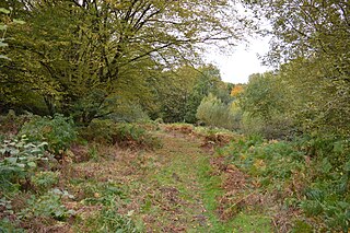
Danemead is a 5.6-hectare nature reserve west of Hoddesdon in Hertfordshire, managed by the Herts and Middlesex Wildlife Trust. It is part of the Wormley-Hoddesdonpark Wood North Site of Special Scientific Interest.
Walverden Water is a minor river in Lancashire, England. It is approximately 2.6 miles (4.2 km) long and has a catchment area of 5.04 square miles (1,304.23 ha).
