

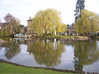
Broxbourne Mill is located at the Old Mill and Meadows Site Lee Valley Park, Broxbourne, Hertfordshire.
Broxbourne Mill is located at the Old Mill and Meadows Site Lee Valley Park, Broxbourne, Hertfordshire.
A mill stood here for 900 years before being destroyed by fire on 1 October 1949. It is the only mill in this area to be mentioned in the Domesday Book 1086. [1] The first known owners were the Knights of St. John of Jerusalem who held the mill to 1544 at the time of the Reformation. The mill ceased the milling of grain in 1891 and was used for a variety of uses until its destruction. [2]
The remnants of the mill which were renovated by the Lee Valley Regional Park Authority [3] in 1977 [4] included c16 brickwork floor and window frames of the c19 two-storey miller's house. The original water wheel has been restored to include replacement paddles made from re-cycled plastic which have a longer life, weigh less therefore placing less stress on the original wheel. Additional work included a new side sluice which when raised allow excess water to pass through.
The mill and its surroundings which are open to the public are known as the Old Mill and Meadows site. The main bulk of which is wet meadows where water voles can be found. During the summer months dragonflies and damselflies are seen hovering over the reedbeds. The small piece of woodland provides habitat for birds and cover for small mammals such as the fox and the muntjac deer. Other activities here are angling which is permitted in the millpool and the millstream. [5] Cycle hire is available in season and a model railway club is open to the public at certain times.
Rail
Buses
By road
By foot and cycle

The River Plym is a river in Devon, England. It runs from Dartmoor in the centre of the county southwest to meet the River Meavy, then south towards Plymouth Sound. The river is popular with canoeists, and the Plym Valley Railway runs alongside a section of the river.

The Lee Navigation is a canalised river incorporating the River Lea. It flows from Hertford Castle Weir to the River Thames at Bow Creek; its first lock is Hertford Lock and its last Bow Locks.

Cheshunt is a town in Hertfordshire, England, 14 miles (23 km) north of London on the River Lea and Lee Navigation. It contains a section of the Lee Valley Park, including much of the River Lee Country Park. To the north lies Broxbourne and Wormley, Waltham Abbey to the east, Waltham Cross and Enfield to the south, and Cuffley to the west.

The River Rother, a waterway in the northern midlands of England, gives its name to the town of Rotherham and to the Rother Valley parliamentary constituency. It rises near Clay Cross in Derbyshire and flows in a generally northwards direction through the centre of Chesterfield, where it feeds the Chesterfield Canal, and on through the Rother Valley Country Park and several districts of Sheffield before joining the River Don at Rotherham in Yorkshire. Historically, it powered mills, mainly corn or flour mills, but most had ceased to operate by the early 20th century, and few of the mill buildings survive.

The River Wandle is a right-bank tributary of the River Thames in south London, England. With a total length of about 9 miles (14 km), the river passes through the London boroughs of Croydon, Sutton, Merton and Wandsworth, where it reaches the Thames. A short headwater – the Caterham Bourne – is partially in Surrey, the historic county of the river's catchment. Tributaries of the Wandle include Carshalton Ponds and Norbury Brook.

The River Blackwater is a tributary of the Loddon in England and sub-tributary of the Thames. It rises at two springs in Rowhill Nature Reserve between Aldershot, Hampshire and Farnham, Surrey. It curves a course north then west to join the Loddon in Swallowfield civil parish, central Berkshire. Part of the river splits Hampshire from Surrey; a smaller part does so as to Hampshire and Berkshire.
Lee Valley Regional Park is a 10,000-acre (40 km2) 26 miles (42 km) long linear park, much of it green spaces, running through the northeast of Greater London, Essex and Hertfordshire from the River Thames to Ware, through areas such as Stratford, Clapton, Tottenham, Enfield, Walthamstow, Waltham Abbey, Cheshunt, Broxbourne and Hoddesdon in an area generally known as the Lea Valley. Greater London's largest park, Lee Valley Park is more than four times the size of Richmond Park, extending beyond Greater London's borders into the neighbouring counties of Hertfordshire and Essex.

Lee Valley White Water Centre is a white-water slalom centre, that was constructed to host the canoe slalom events of the London 2012 Olympic Games. On 9 December 2010, Anne, Princess Royal officially opened the venue which is owned by Lee Valley Regional Park Authority and was originally managed by them as well, but since April 1, 2022, is now managed by Greenwich Leisure Limited (GLL) under its "Better" brand. The £31 million project to construct the centre finished on schedule and was the first newly constructed Olympic venue to be completed.
Enfield Lock is an area in the London Borough of Enfield, north London. It is approximately located east of the Hertford Road between Turkey Street and the Holmesdale Tunnel overpass, and extends to the River Lee Navigation, including the Enfield Island Village. The locality gains its name from the lock on the River Lee Navigation. Today's Enfield Lock was rebuilt in 1922. The area forms part of the Lee Valley Park and the Enfield Lock Conservation Area. On its eastern boundary Enfield Lock has marshland formerly used as a testing site between the Royal Small Arms Factory and the Gunpowder Mills, beyond this is the village of Sewardstone and the Epping forest boundary. To the south is Brimsdown, the north Waltham Cross and to the west Bullsmoor and Freezywater. Enfield Lock forms part of the London boundary.

Broxbourne is a town and former civil parish, now in the unparished area of Hoddesdon, in the Borough of Broxbourne district, in Hertfordshire, England, with a population of 15,303 at the 2011 Census. It is located to the south of Hoddesdon and to the north of Cheshunt, 17.1 miles (27.5 km) north of London. The town is near the River Lea, which forms the boundary with Essex, and 4.5 miles (7.2 km) north of the M25 motorway. To the west of the town are Broxbourne Woods, a national nature reserve. The Prime Meridian runs just east of Broxbourne.

Dobbs Weir is both a weir in Hoddesdon, Hertfordshire and an area of Roydon, Essex in England on the River Lea. It is well known for angling, outdoor beauty and watersports. It is overlooked by the Fish and Eels pub.

The Lea Valley Walk is a 50-mile (80 km) long-distance path located between Leagrave, the source of the River Lea near Luton, and the Thames, at Limehouse Basin, Limehouse, east London. From its source much of the walk is rural. At Hertford the path follows the towpath of the River Lee Navigation, and it becomes increasingly urbanised as it approaches London. The walk was opened in 1993 and is waymarked throughout using a swan logo.

Carthagena Weir is a weir located at Broxbourne on the River Lea. The well oxygenated water with depths ranging to over 16 ft, makes it an ideal environment for coarse fish including the common barbel.

Fishers Green is a settlement 1 mile (1.6 km) to the north of the town of Waltham Abbey, Essex, England, in the parish of Waltham Abbey. It lies on the flood plain of the River Lea.

Leyton Marsh is an open space in the Lower Lea Valley, located in Leyton in the London Borough of Waltham Forest.

The Coppermill Stream is a short waterway near Walthamstow in the Lea Valley. Originally a minor tributary of the River Lea, the approximately 2-mile (3.2 km) long stream is now used as an aqueduct to transport water from the reservoirs in the Lea Valley to Coppermills Water Treatment Works. The stream is part of a Site of Metropolitan Importance.

The River Lee Country Park is located in the Lee Valley Park and is managed by the Lee Valley Regional Park Authority. Covering 1,000 acres (400 ha) on either side of the River Lee Navigation between Waltham Abbey and Broxbourne, it is an area of lakes, watercourses, open spaces and three Sites of Special Scientific Interest (SSSI) linked by footpaths and cycle tracks.
The River Lynch, also known as the Lynch Brook, is a minor tributary of the River Lea in Hoddesdon, Hertfordshire, England.

Rammey Marsh is located in the Lee Valley Park at Enfield Lock, Enfield, and covers approximately 42 hectares. The site is owned and managed by the Lee Valley Regional Park Authority.

Turnford is a village in the Borough of Broxbourne, in Hertfordshire, England, in an area generally known as the Lee Valley. It is bounded by Wormley to the north, Cheshunt to the south and west, and its eastern boundary is formed largely by the Lee Navigation. Central London at Charing Cross is approximately 18 miles (29 km) south. At the 2001 census, together with Wormley, the village had a population of 8,146 in 3,399 households.