The River Lea is in the East of England and Greater London. It originates in Bedfordshire, in the Chiltern Hills, and flows southeast through Hertfordshire, along the Essex border and into Greater London, to meet the River Thames at Bow Creek. It is one of the largest rivers in London and the easternmost major tributary of the Thames.

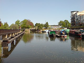
The Lee Navigation is a canalised river incorporating the River Lea. It flows from Hertford Castle Weir to the River Thames at Bow Creek; its first lock is Hertford Lock and its last Bow Locks.
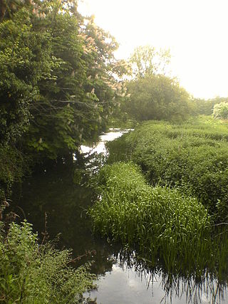
The River Rib is a tributary of the River Lea, which runs from Buckland in Hertfordshire, England. It flows into the River Lea to the east of Hertford.

The River Mimram is a chalk stream in Hertfordshire, England. It runs from its source near Whitwell in Hertfordshire to join the River Lea at Hertford.

The River Stort is a river in Essex and Hertfordshire, England. It is 24 miles (39 km) long and flows from near the village of Langley to the River Lea at Hoddesdon.

St. Margaretsbury Football Club is a football club based in Stanstead Abbotts, near Ware, Hertfordshire, England. They are currently members of the Eastern Counties League Division One South and play at the Recreation Ground.
The Lea Valley, the valley of the River Lea, has been used as a transport corridor, a source of sand and gravel, an industrial area, a water supply for London, and a recreational area. The London 2012 Summer Olympics were based in Stratford, in the Lower Lea Valley. It is important for London's water supply, as the source of the water transported by the New River aqueduct, but also as the location for the Lee Valley Reservoir Chain, stretching from Enfield through Tottenham and Walthamstow.

The River Beane is a short river in the county of Hertfordshire, England. A tributary of the River Lea, it rises to the south-west of Sandon in the hills northeast of Stevenage and joins the Lea at Hartham Common in Hertford.

Turkey Brook is a river in the northern outskirts of London. It rises in Potters Bar, Hertfordshire, and flows broadly eastwards to merge with the River Lea Navigation near Enfield Lock.

Stanstead Abbotts is a village and civil parish in the district of East Hertfordshire, Hertfordshire, England; it lies on the county boundary with Essex. At the 2001 census, the parish had a population of 1,983.

Pymmes Brook is located in North London and named after William Pymme, a local land owner. It is a minor tributary of the River Lea. The brook mostly flows through urban areas and is particularly prone to flooding in its lower reaches. To alleviate the problem the brook has been culverted in many areas. Part of it is a Site of Borough Importance for Nature Conservation, Grade II.

The River Quin is a small watercourse which rises near Barkway in north east Hertfordshire, England, and flows into the River Rib, which is a tributary of the River Lea.

Salmons Brook is a minor tributary of the River Lea, located in the London Borough of Enfield.
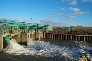
The Lee Flood Relief Channel (FRC) is located in the Lea Valley and flows between Ware, Hertfordshire, and Stratford, east London. Work started on the channel in 1947 following major flooding and it was fully operational by 1976. The channel incorporates existing watercourses, lakes, and new channels. Water from the channel feeds the Lee Valley Reservoir Chain.

The Spital Brook is a minor tributary of the River Lea in Hertfordshire, England.

Cuffley Brook is a tributary of Turkey Brook. It runs through parts of Hertfordshire and the London Borough of Enfield, England. After the confluence of the two streams in Whitewebbs Park, the watercourse continues eastwards as Turkey Brook to join the River Lea near Enfield Lock.

Stanstead St Margarets, often abbreviated to just St Margarets, is a village and civil parish in the district of East Hertfordshire, Hertfordshire, England. It is located halfway between the towns of Hoddesdon and Ware. The village is separated from the village of Stanstead Abbotts by the River Lea, and had a population of 1,318 at the census of 2001, increasing to 1,652 at the 2011 Census.

Rye House in Hoddesdon, Hertfordshire is a former fortified manor house, located in what is now the Lee Valley Regional Park. The gatehouse is the only surviving part of the structure and is a Grade I listed building. The house gave its name to the Rye House Plot, an assassination attempt of 1683 that was a violent consequence of the Exclusion Crisis in British politics at the end of the 1670s.
The Woollens Brook is a minor tributary of the River Lea which flows through Hoddesdon in Hertfordshire, England.

Houghton Brook, the lower section sometimes known as Knapps Brook, is a minor tributary of the River Lea which flows through the northwest suburbs of Luton.


