Canning Town

Last updated

Canning Town
Royal Victoria Dock - with Canary Wharf and the Millennium Dome in the background - geograph.org.uk - 1168534.jpg
Royal Victoria Dock - with Canary Wharf and the O2 Arena in the background
Greater London UK location map 2.svg
Red pog.svg
Canning Town
Location within Greater London
Population42,667 (Canning Town North And Canning Town South wards, 2021) [1]
OS grid reference TQ4081
London borough
Ceremonial county Greater London
Region
Country England
Sovereign state United Kingdom
Post town LONDON
Postcode district E16, E13
Dialling code 020
Police Metropolitan
Fire London
Ambulance London
UK Parliament
London Assembly
List of places
UK
England
London
51°30′54″N0°01′34″E / 51.515°N 0.026°E / 51.515; 0.026

Canning Town is a district in the London Borough of Newham, East London. The district is located to the north of the Royal Victoria Dock, and has been described as the "Child of the Victoria Docks" as the timing and nature of its urbanisation was largely due to the creation of the dock. The area was part of the ancient parish of West Ham, in the hundred of Becontree, and part of the historic county of Essex. It forms part of the London E16 postcode district.

Contents

The area, the location of the Rathbone Market, is undergoing significant regeneration as of 2012. According to Newham Council: "The Canning Town and Custom House Regeneration Programme includes the building of up to 10,000 new homes, creation of thousands of new jobs and two improved town centres. This £3.7 billion project aims to transform the area physically, socially and economically." [2]

History

Map c1872, showing Victoria Docks, now Royal Victoria Dock, Bow Creek and the Thames Ironworks and Shipbuilding Company. Victoria Docks 1872.jpg
Map c1872, showing Victoria Docks, now Royal Victoria Dock, Bow Creek and the Thames Ironworks and Shipbuilding Company.
Map 1908, showing Canning Town to the north of Royal Victoria Dock and Silvertown to the south of the dock. Canning Town and Royal Victoria Dock 1908.jpg
Map 1908, showing Canning Town to the north of Royal Victoria Dock and Silvertown to the south of the dock.
Canning Town welcomes Gandhi, 1931. An admiring East End crowd gathers to witness the arrival of Mahatma Gandhi.jpg
Canning Town welcomes Gandhi, 1931.
Bidder Street in 1891, one of the oldest parts of Canning Town. The Bidder Street area is now an industrial area Bidder Street 1891.jpg
Bidder Street in 1891, one of the oldest parts of Canning Town. The Bidder Street area is now an industrial area
The West Ham Power Station, also known as Canning Town Power Station, next to Bow Creek on Tucker Street in 1973 West Ham B Power Station.jpg
The West Ham Power Station, also known as Canning Town Power Station, next to Bow Creek on Tucker Street in 1973

Prior to the 19th century, the district was largely marshland, and accessible only by boat, or a toll bridge. In 1809, an Act of Parliament was passed for the construction of the Barking Road between the East India Docks and Barking. A five-span iron bridge was constructed in 1810 to carry the road across the River Lea at Bow Creek. This bridge was damaged by a collision with a collier in March 1887 and replaced by the London County Council (LCC) in 1896. This bridge was in turn replaced in 1934, [3] at a site to the north and today's concrete flyover begun in smaller form in the 1960s, but successively modified to incorporate new road layouts for the upgraded A13 road and a feeder to the Limehouse Link tunnel, avoiding the Blackwall Tunnel. The abutments of the old iron bridge have now been utilised for the Jubilee footbridge, linking the area to Leamouth, in the London Borough of Tower Hamlets, on the western bank of the Lea.
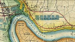
The first workers' homes built in Canning Town around 1850. Worker's homes Canning Town 1850.gif
The first workers' homes built in Canning Town around 1850.

The area is thought to be named after the first Viceroy of India, Charles John Canning, who suppressed the Indian Mutiny about the time the district expanded. The population increased rapidly after the North London Line was built from Stratford to North Woolwich, in 1846. This was built to carry coal and goods from the docks; and when the passenger station was first built it was known as Barking Road. [4] Speculative builders constructed houses for the workers attracted by the new chemical industries established in the lower reaches of the River Lea, and for the nearby Thames Ironworks and Shipbuilding Company and Tate & Lyle refinery. [5]

The opening of the Royal Victoria Dock in 1855 accelerated the development of the area [3] creating employment and a need to house dock workers and their families. New settlements around the dock developed, starting with Hallsville, Canning Town and Woolwich, and later the areas now known as Custom House, Silvertown and West Silvertown. The new settlements lacked water supply and had no sewage system, leading to the spread of cholera and smallpox. [6] The casual nature of employment at the docks meant poverty and squalid living conditions for many residents, [5] and in 1857 Henry Morley wrote about the area:

"Canning Town is the child of the Victoria Docks. The condition of this place and of its neighbour prevents the steadier class of mechanics from residing in it. They go from their work to Stratford or to Plaistow. Many select such a dwelling place because they are already debased below the point of enmity to filth; poorer labourers live there, because they cannot afford to go farther, and there become debased. The Dock Company is surely, to a very great extent, answerable for the condition of the town they are creating. Not a few of the houses in it are built by poor and ignorant men who have saved a few hundred pounds, and are deluded by the prospect of a fatally cheap building investment."

Londoners over the Border, Household Words [7]

The industries around the dock were often unhealthy and dangerous. As trade unions and political activists fought for better living conditions and the dock area became the centre of numerous movements with Will Thorne, James Keir Hardie and other later becoming leading figures in the Labour Party. [6] Thorne and others worked and gave speeches at Canning Town Public Hall which had been built in 1894 as the population grew in the southern part of the borough.

From the late 19th century, a large African mariner community was established in Canning Town as a result of new shipping links to the Caribbean and West Africa. [8] Prior to the Windrush era, Canning Town had London's largest black population of any area in London. [9] The area around Crown Street (formerly located just north of the Royal Victoria Dock, but destroyed in the Blitz) was known as Draughtboard Alley due its ethnic mix. [10]

Notable black people from Canning Town include footballers Fred Corbett, who played for Thames Ironworks F.C. and its successor team West Ham United; and Jack Leslie, who was called up to play for England, but then dropped without explanation, possibly due to racial prejudice. [11] Another example of the area's long-standing multi-cultural nature is Indian-born doctor Chuni Lal Katial, who practised in Canning Town for several years from around 1929. Katial was an acquaintance of Mahatma Gandhi and invited him to meet Charlie Chaplin, one of the most famous actors in the world, at his surgery in Beckton Road. Gandhi was staying at Kingsley Hall, in nearby Bromley-by-Bow, for the three-month duration of his talks with the UK government on the future of India. [12] Katial, a noted health pioneer, later moved to the Metropolitan Borough of Finsbury, in north London, where he became Britain's first south Asian Mayor.

In 1917 50 tons of TNT exploded at the Brunner Mond & Co ammunition work in nearby Silvertown, causing the Silvertown explosion, the largest explosion in London's history and damaging more than 70,000 buildings and killing 73 people. [6]

In the 1930s the County Borough of West Ham commenced slum clearances. [5] New houses, clinics, nurseries and a lido were opened. Silvertown ByPass and Britain's first flyover, the Silvertown Way, were built along with other new approach roads to the docks. Canning Town was heavily hit by the bombings in World War II and West Ham Council's plan to rebuild the area focused on a reduction of the population, transferring industry and the building of new housing such as the Keir Hardie Estate, which included schools and welfare services. [6] In the early hours of 10 September 1940, a bomb hit South Hallsville School where up to 600 local refugees were accommodated. At least 200, mainly children, were killed or injured. Many bodies were never recovered. [13]

The slum clearances and the devastation of World War II, destroying 85% of the housing stock, led to the preponderance of council estates that characterise the area today. [5] Post-war housing schemes followed the urban planning principles of the garden city movement. As demand for housing grew the first high rise buildings were built in Canning Town in 1961. In 1968 part of Ronan Point, a 22-storey tower block in Newham, collapsed and most of the tall tower blocks built in the area in the early 1960s were eventually demolished or reduced in size. [6]

Slum housing

Notice to the poor on cholera, 1848. From the minutes of the West Ham Board of Guardians. States amongst others: "The Guardians are prepared to issue "CERTIFICATES" to the Poor generally, entitling them to Medical Relief gratuitously, should "CHOLERA" break out, or its symptoms prevail in the Neighbourhood." Note to the Poor on Cholera 1848 West Ham.jpg
Notice to the poor on cholera, 1848. From the minutes of the West Ham Board of Guardians. States amongst others: "The Guardians are prepared to issue "CERTIFICATES" to the Poor generally, entitling them to Medical Relief gratuitously, should "CHOLERA" break out, or its symptoms prevail in the Neighbourhood."
The Little Tommy Lee sewer, an open sewer in Canning Town, c.1888 Little Tommy Lee sewer.jpg
The Little Tommy Lee sewer, an open sewer in Canning Town, c.1888

Victorian era

In 1857 Henry Morley published a detailed description of the area in Charles Dickens' Household Words entitled "Londoners over the Border", writing:

"...by the law there is one suburb on the border of the Essex marshes which is quite cut off from the comforts of the Metropolitan Buildings Act;-in fact, it lies just without its boundaries, and therefore is chosen as a place of refuge for offensive trade establishments turned out of the town, - those of oil boilers, gut spinners, varnish makers, printers ink makers and the like. Being cut off from the support of the Metropolitan Local Managing Act, this outskirt is free to possess new streets of houses without drains, roads, gas, or pavement." [7]

Describing the slum housing conditions and its effect on the health of local residents, Morley wrote:

"Rows of small houses, which may have cost for their construction eighty pounds a piece, are built designedly and systematically with their backs to the marsh ditches; ...to or three yards of clay pipe "drain" each house into the open cess pool under its back windows, when it does not happen that the house is built as to overhang it... In winter time every block becomes now and then an island, and you may hear a sick man, in an upper room, complain of water trickling down over his bed. Then the flood cleans the ditches, lifting all their filth into itself, and spreading it over the land. No wonder that the stench of the marsh in Hallsville and Canning Town of nights, is horrible. A fetid mist covers the ground... the parish surgeon... was himself for a time invalided by fever, upon which ague followed. Ague, of course, is one of the most prevalent diseases of the district; fever abounds. When an epidemic comes into the place, it becomes serious in its form, and stays for months. Disease comes upon human bodies saturated with the influences of such air as is breathed day and night, as a spark upon touchwood. A case or two of small pox caused, in spite of vaccination, an epidemic of confluent small pox, which remained three or four months upon the spot." [7]

Morley also describes efforts to improve the housing conditions in the area:

"Two years ago, when application was made by more than a tenth of the rate payers of the parish of West Ham for an inquiry into the sanitary condition of the district, with a view to bringing it under the conditions of the Public Health Act, Mr Alfred Dickens was the civil engineer sent by the general Board of Health as an inspector. His report and the evidence at his inquiry is before us as we write, and it dwells very much upon the state of Canning Town and Hallsville. We learn from this report that the area of the ditches in the parish amounted to not less than one hundred and fifty acres, according to a surveyors book upwards of thirty five years old, and that area has been increased by side cuttings at the railway and new cuttings of open sewer. Disease had cost the parish six hundred pounds in the year previous to the inquiry. There was then, of course, as now, no drainage or paving in Canning Town; the roads in winter were impassable; but the inhabitants were paying (for what they did not get) an eighteen penny rate under the Commissioners Act, not for works done in accordance with it, but "for the expenses of the act". Also, although the parish did not take charge of their roads, they were paying a highway rate for the parishioners elsewhere. One horrible detail in Mr Dickens report has, happily, to be omitted from our sketch. Two years ago, there was in Hallsville and Canning Town no water supply. Good water is now laid on. In all other respects, the old offences against civilised life cleave to the district. The local Board of Health which the inhabitants of the parish sought and obtained, whatever it may have done for Stratford, seems to have done nothing for Hallsville, unless it be considered something to indulge it with an odd pinch of deodorising powder." [7]

Alfred Dickens highlighted the severe overcrowding suffered by many of the slum inhabitants as a result of landlord charging high rents and households relying on casual work. [14]

20th century

The 1890 Housing Act made the local council responsible for providing decent accommodation, and in the 1890s some of the first council houses were built in Bethell Avenue. However, many of the terraced houses built during the late 19th century were little more than slums and cleared by the council in the 1930s. The council replaced the terraces with the first high-rise blocks. [15]

Today

According to Newham London Borough Council, Canning Town and Custom House are among the five per cent most deprived areas in the UK. Residents suffer from poor health, low education and poverty. 17 per cent of the working age population have a limiting long-term illness, 17.5 per cent claim income support and 49.7 per cent of 16- to 74-year-olds have no formal qualifications. [16]

Regeneration project

The consultation and governance mechanism of the currently ongoing regeneration project is underpinning by a partnership between councillors, residents, local businesses and other "partners". [16] According to Newham council:

"The views of residents and businesses is central to the development and delivery of the regeneration initiative and developers will be expected to continue with extensive community consultation and engagement as part of their remit." [16]

Newham council is currently attempting to encourage "re-interpretations" of London's established street and housing forms. The council has identified terraced housing as such housing form, stating that it "continues to have enduring popularity with all types of residents including families and children". [16]

The area is at the western end of the Thames Gateway zone and is currently undergoing a £2.7 billion regeneration project, which includes:

The Olympic Uniform Distribution and Accreditation Centre, which was located in Canning Town, was due to be demolished and replaced with a new industrial estate as part of the Olympic Legacy programme. [17]

Politics and local government

The area falls within the parliamentary constituency of West Ham. The local Member of Parliament is Lyn Brown from Labour. The ward is located in the London Borough of Newham.

In May 2002, Canning Town South was the only ward in the Borough to return a non-Labour councillor. In 2006, residents elected three Christian Peoples Alliance candidates, one of whom was Alan Craig. In 2010, Labour gained all three seats and have held them with significant majorities since.

2022 Local Election

Canning Town South (3)
PartyCandidateVotes%±%
Labour Rohit Kumar Dasgupta 630
Labour Alan Griffiths 585
Labour Belgica Guana 536
Independent Carel Jane Buxton187
Green Oliver Reynolds185
Green Deb Scott161
Independent Darshi Wijesinghe155
Conservative Tim Gamble144
Conservative Marc James Pooler122
Green Benjamin Ian Smith106
Conservative Rachel Nabudde103
CPA Myrtle Verona Laing74
CPA Sharmila Sundar Swarna54
CPA Prossy Namwanje50
Turnout
Labour hold Swing
Labour hold Swing
Labour hold Swing

-->

Canning Town South - 2018 (3) [18]
PartyCandidateVotes%±%
Labour Alan Griffiths* 1,991
Labour Rohit K Dasgupta 1,965
Labour Belgica Guana 1,693
Liberal Democrats Caroline Carey652
Conservative Marc Pooler643
Conservative Mark Seymour559
Green Danny Keeling464
Conservative Mahyar Tousi378
CPA Myrtle Laing222
CPA Sharmila Swarna145
CPA Prossy Namwanje144
Turnout 28.2
Registered electors 11,749
Labour hold Swing
Labour hold Swing
Labour hold Swing
Canning Town South - 2014 (3) [19]
PartyCandidateVotes%±%
Labour Bryan Collier 1,896
Labour Alan Griffiths 1,600
Labour Sheila Thomas 1,581
UKIP Kay McKenzie657
Conservative Abul Mohammed632
Conservative Gareth Knight537
Conservative Jaja Rachel420
CPA Faith Johnson387
CPA Benjamin Stafford279
CPA Ethel Odiete237
Turnout 33.0
Registered electors 10,170
Labour hold Swing
Labour hold Swing
Labour hold Swing
Canning Town South - 2010 (3) [19]
PartyCandidateVotes%±%
Labour Bryan Collier 2,263
Labour Alan Taylor 2,074
Labour Michael Nicholas 2,028
CPA Alan Craig 1,399
CPA Denise Stafford1,004
CPA Hamilton Amachree892
Conservative Christopher Buckwell858
Conservative Gareth Knight794
Conservative Abul Kashem721
Turnout 43.8
Registered electors 9,187
Labour gain from CPA Swing
Canning Town South - 2006 (3)
PartyCandidateVotes%±%
CPA Alan Craig 1,536
CPA Denise Stafford 1,170
CPA Simeon Ademolake 1,091
Labour Bryan Collier927
Labour Alan Griffiths887
Labour Julie Sussex855
Conservative Christopher Buckwell332
Conservative Abul Abdul306
Respect Khadija Hassan225
Conservative Bakary Ceesay193
Respect Mohammed Abdur Rob193
Respect Berlyne Hamilton192
Turnout 32.8
Registered electors 8,661
CPA hold Swing
CPA gain from Labour Swing
Canning Town South - 2002 (3)
PartyCandidateVotes%±%
CPA Alan Craig 959
Labour Alan Taylor 946
Labour Maureen Jones 887
Labour Simon Tucker808
CPA Benjamin Stafford739
CPA Rose Irtwangejibril525
Turnout 26.2
Registered electors 7,601
CPA gain from Labour Swing
Labour hold Swing
Labour hold Swing
Canning Town South - 1998 (2)
PartyCandidateVotes%±%
Labour Clive Furness 797
Labour Robert Wales 617
Liberal Democrats Kathleen Chater267
Conservative Brendan Morley191
BNP Michael Davidson186
Conservative Simon Pearce145
Turnout 22.8
Registered electors 5,483
Labour hold Swing
Labour hold Swing

Culture

Thames Ironworks F.C., the works team of the nearby Ironworks, went on to become West Ham United F.C. after turning professional.

The Bridge House, a public house named for the 1887 Iron Bridge, was at 23 Barking Road now demolished. The venue operated during the 1970s and 1980s and was host to The Police, Depeche Mode, Jeff Beck, Billy Bragg, Alexis Korner, Modern Romance, Sham 69, Lindisfarne, The Cockney Rejects, Iron Maiden, Remus Down Boulevard and many other notable acts. [20] A venue bearing the name The Bridge House 2 was opened in Bidder Street in more recent years. [21]

Education

Transport

London Buses route 5, 69, 115, 147, 241, 300, 309, 323, 330, 474 and night routes N15, N550 and N551 all serve Canning Town at the bus station, [22]

Route D3 starts/ends at Leamouth [23] and route 276 runs on Barking Road, and 325 route at Canning Town Recreation Ground and Custom House, [24] [25] and route 473 and school route 678 start at Prince Regent bus station.

Related Research Articles

<span class="mw-page-title-main">Stratford, London</span> Human settlement in England

Stratford is a town in East London, England, within the London Borough of Newham. Part of the Lower Lea Valley, Stratford is situated 6 miles (9.7 km) east-northeast of Charing Cross, and includes the localities of Maryland and East Village.

<span class="mw-page-title-main">West Ham</span> District in East London, England

West Ham is an area in East London, located 6.1 mi (9.8 km) east of Charing Cross in the west of the modern London Borough of Newham.

<span class="mw-page-title-main">London Borough of Newham</span> Inner Borough of London, England

The London Borough of Newham is a London borough created in 1965 by the London Government Act 1963. It covers an area previously administered by the Essex county boroughs of West Ham and East Ham, authorities that were both abolished by the same act. The name Newham reflects its creation and combines the compass points of the old borough names. Situated in the Inner London part of East London, Newham has a population of 387,576, which is the third highest of the London boroughs and also makes it the 16th most populous district in England. The local authority is Newham London Borough Council.

<span class="mw-page-title-main">Plaistow, Newham</span> Town in East London, England

Plaistow is a suburban area of East London, England, within the London Borough of Newham. It adjoins Upton Park to the north, East Ham to the east, Beckton to the south, Canning Town to the south-west and West Ham to the west.

<span class="mw-page-title-main">Silvertown</span> Human settlement in England

Silvertown is a district in the London Borough of Newham, in east London, England. It lies on the north bank of the Thames and was historically part of the parishes of West Ham and East Ham, hundred of Becontree, and the historic county of Essex. Since 1965, Silvertown has been part of the London Borough of Newham, a local government district of Greater London. It forms part of the London E16 postcode district along with Canning Town and Custom House.

<span class="mw-page-title-main">East Ham</span> Suburban district of London, England

East Ham is a district of the London Borough of Newham, England, 8 miles (12.8 km) east of Charing Cross. Within the boundaries of the historic county of Essex, East Ham is identified in the London Plan as a Major Centre. The population is 76,186.

<span class="mw-page-title-main">North Woolwich</span> Area of Newham in London, England

North Woolwich is an area in the London Borough of Newham in East London, England, on the northern bank of the River Thames, across the river from Woolwich. It is connected to Woolwich by the Woolwich Ferry and Woolwich foot tunnel.

<span class="mw-page-title-main">Royal Docks</span> Area in Newham, London

Royal Docks is an area and a ward in the London Borough of Newham in the London Docklands in East London, England.

<span class="mw-page-title-main">Beckton</span> Area in East London, England

Beckton is a suburb in east London, England, located 8 miles (12.9 km) east of Charing Cross and part of the London Borough of Newham. Adjacent to the River Thames, the area consisted of unpopulated marshland known as the East Ham Levels in the parishes of Barking, East Ham, West Ham and Woolwich. The development of major industrial infrastructure in the 19th century to support the growing metropolis of London caused an increase in population with housing built in the area for workers of the Beckton Gas Works and Beckton Sewage Treatment Works. The area has a convoluted local government history and has formed part of Greater London since 1965. Between 1981 and 1995 it was within the London Docklands Development Corporation area, which caused the population to increase as new homes were built and the Docklands Light Railway was constructed.

<span class="mw-page-title-main">Leamouth</span> Human settlement in England

Leamouth is a locality in the Blackwall area of the London Borough of Tower Hamlets. The area takes its name from the former Leamouth Wharf and lies on the west side of the confluence of the Bow Creek stretch of the Lea, at its confluence with the River Thames.

<span class="mw-page-title-main">Lower Lea Valley</span> Southern end of the Lea Valley in Greater London

The Lower Lea Valley is the southern end of the Lea Valley which surrounds the River Lea in eastern Greater London. It is part of the Thames Gateway redevelopment area and was the location of the 2012 Summer Olympics.

<span class="mw-page-title-main">East London</span> Northeastern part of London, United Kingdom

East London is the northeastern part of London, England, east of the ancient City of London and north of the River Thames as it begins to widen. East London developed as London's docklands and the primary industrial centre. The expansion of railways in the 19th century encouraged the eastward expansion of the East End of London and a proliferation of new suburbs. The industrial lands of East London are today an area of regeneration, which are well advanced in places such as Canary Wharf and ongoing elsewhere.

<span class="mw-page-title-main">County Borough of West Ham</span> Historical local government district in the extreme south west of Essex

West Ham was a local government district in the extreme south west of Essex from 1886 to 1965, forming part of the built-up area of London; it was also referred to as one of the original areas of the East End of London although administratively it was just outside the County of London. It was immediately north of the River Thames and east of the River Lea.

<span class="mw-page-title-main">Parks and open spaces in the London Borough of Newham</span>

The London Borough of Newham, in spite of being one of the more crowded areas of London, has over 20 parks within its boundaries, as well as smaller recreation grounds. The larger parks in the Borough include:

<span class="mw-page-title-main">Custom House, Newham</span> Area in London, England

Custom House is an area in the London Borough of Newham, in East London, England.

<span class="mw-page-title-main">Silvertown (UK Parliament constituency)</span> Parliamentary constituency in the United Kingdom, 1918–1950

Silvertown was a borough constituency returning a single Member of Parliament (MP) to the House of Commons of the Parliament of the United Kingdom through the first-past-the-post voting system. The constituency was one of four divisions of the Parliamentary Borough of West Ham, which had at the time the same boundaries as the County Borough of West Ham. Although administratively separate since 1889, the area was formally part of the county of Essex; since 1965 it has been part of the London Borough of Newham in Greater London.

The Docklands Light Railway extension to Thamesmead is a proposed Docklands Light Railway (DLR) extension to serve the Beckton Riverside and Thamesmead redevelopment areas of East London.

<span class="mw-page-title-main">St Mark's Church, Silvertown</span> Former church in east London, now a music venue

St Mark's Church, Silvertown or St Mark's Church, Victoria Docks is a former church building in Silvertown in east London, located on North Woolwich Road. It takes one of its names from the nearby Royal Docks. It was listed as Grade II* in 1971 and now houses the Brick Lane Music Hall.

<span class="mw-page-title-main">St Luke's Church, Canning Town</span> Church in Newham, east London, England

St Luke's Church, Canning Town or St Luke's Church, Victoria Docks is a Church of England church, originally housed in a building on Boyd Road in the Royal Docks area of West Ham in east London.

References

  1. Newham Wards population 2021.
  2. 2QU, London Borough of Newham, Newham Dockside/Docklands, 1000 Dockside Road, London, E16. Canning Town and Custom House regeneration.{{cite book}}: CS1 maint: multiple names: authors list (link) CS1 maint: numeric names: authors list (link)
  3. 1 2 "West Ham: Rivers, bridges, wharfs and docks". A History of the County of Essex: Volume 6. 1973. pp. 57–61. Retrieved 29 May 2008 via British History Online.
  4. "West Ham: Transport and postal services". A History of the County of Essex: Volume 6. 1973. pp. 61–63. Retrieved 16 January 2008 via British History Online.
  5. 1 2 3 4 "West Ham: Domestic buildings". A History of the County of Essex: Volume 6. 1973. pp. 50–57. Retrieved 17 January 2008 via British History Online.
  6. 1 2 3 4 5 "The Royal Docks – a short history". Royal Docks Trust. Archived from the original on 11 August 2017. Retrieved 28 June 2010.
  7. 1 2 3 4 Morley, Henry (1857). Dickens, Charles (ed.). "Londoners over the Border" (PDF). Household Words . XVI (390) via Dickens Journals Online.
  8. Bell, Geoffrey (2002). The other Eastenders: Kamal Chunchie and West Ham's early black community. Stratford: Eastside Community Heritage.
  9. Brewer's Dictionary of London Phrase and Fable, Russ Willey, Chambers, 2009
  10. Heritage Project around black history in Canning Town http://www.irokotheatre.org.uk/projects/6.pdf
  11. Article on Jack leslie's career https://www.whufc.com/news/articles/2021/october/25-october/jack-leslie-east-londoner-who-should-have-been-englands-first
  12. Article on the meeting between Gandhi and Chaplin https://www.royaldocks.london/articles/when-chaplin-met-gandhi-in-canning-town-royal-docks-history
  13. Calder, Simon (20 November 2017). "Blitz: The bombs that changed Britain". The Independent. Retrieved 23 November 2017.
  14. "Conditions in Canning Town in Victorian Times". Archived from the original on 29 August 2008. Retrieved 23 November 2017.
  15. "Housing in Canning Town in Victorian Times". Archived from the original on 21 August 2008. Retrieved 23 November 2017.
  16. 1 2 3 4 "Canning Town and Custom House regeneration". Newham Council. 2009. Archived from the original on 16 December 2010. Retrieved 2 December 2010.
  17. "Stephenson Report" (PDF). London Borough of Newham.
  18. "London Borough Council Elections 3 May 2018" (PDF). London Datastore. London Residuary Body. Retrieved 29 December 2019.
  19. 1 2 Statement as to persons nominated - Canning Town South Archived 16 July 2011 at the Wayback Machine (LB Newham) accessed 12 April 2010
  20. Terence Murphy The Bridge House, Canning Town: Memoires of a Legendary Rock and Roll Hangout (2007)
  21. "Bridge House 2". timeout.com. 9 October 2015. Retrieved 3 March 2018.
  22. "Canning Town - Transport for London". Tfl.gov.uk. Retrieved 9 May 2020.
  23. "Leamouth / Orchard Place - Transport for London". Tfl.gov.uk. Retrieved 9 May 2020.
  24. "Canning Town Recreation Ground - Transport for London". Tfl.gov.uk. Retrieved 9 May 2020.
  25. "Custom House Station - Transport for London". Tfl.gov.uk. Retrieved 9 May 2020.