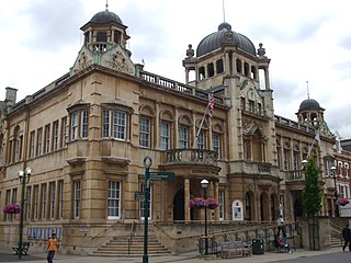
Ilford is a large town in east London, England, 9 miles (14 km) northeast of Charing Cross. Part of the London Borough of Redbridge, Ilford is within the ceremonial county of Greater London. It had a population of 168,168 in 2011, compared to 303,858 for the entire borough.

Becontree or is an area of approximately 4 square miles (10 km2) in the London Borough of Barking and Dagenham. It is located 11 miles (17.7 km) east-northeast of Charing Cross and was constructed in the interwar period as the largest public housing estate in the world. The Housing Act 1919 permitted the London County Council to build housing outside the County of London and Becontree was constructed between 1921 and 1935 to cottage estate principles in the parishes of Barking, Dagenham and Ilford, then in the administrative and ceremonial county of Essex. The official completion of the estate was celebrated in 1935, by which time the estate had a population of around 100,000 people in 26,000 homes.

Romford is a large town in East London, England, 14 miles (23 km) northeast of Charing Cross. Part of the London Borough of Havering, the town is one of the major metropolitan centres of Greater London identified in the London Plan.
West Ham is a district in East London, England and is in the London Borough of Newham. It is an inner-city suburb located 6.1 mi (9.8 km) east of Charing Cross.

The London Borough of Barking and Dagenham is a London borough in East London. It lies around 9 miles (14 km) east of Central London. The borough was created in 1965 as the London Borough of Barking; the name was changed in 1980. It is an Outer London borough and the south is within the London Riverside section of the Thames Gateway; an area designated as a national priority for urban regeneration. At the 2011 census it had a population of 187,000. The borough's three main towns are Barking, Chadwell Heath and Dagenham. The local authority is the Barking and Dagenham London Borough Council. Barking and Dagenham was one of six London boroughs to host the 2012 Summer Olympics.
Dagenham is a town in East London, England, within the London Borough of Barking and Dagenham. Dagenham is centred 11+1⁄2 miles east of Charing Cross.

Barking is a riverside town in East London, England, within the London Borough of Barking and Dagenham. It is 9.3 miles (15 km) east of Charing Cross. The total population of Barking was 59,068 at the 2011 census. In addition to an extensive and fairly low-density residential area, the town centre forms a large retail and commercial district, currently a focus for regeneration. The former industrial lands to the south are being redeveloped as Barking Riverside.
North Woolwich is an area in the London Borough of Newham in East London, England, on the northern bank of the River Thames, across the river from Woolwich. It is connected to Woolwich by the Woolwich Ferry and Woolwich foot tunnel.
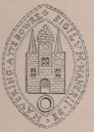
Havering, also known as Havering-atte-Bower, was a royal manor and ancient liberty whose area now forms part of, and gives its name to, the London Borough of Havering in Greater London. The manor was in the possession of the Crown from the 11th to the 19th centuries and was the location of Havering Palace from the 13th to the late 17th century. It occupied the same area as the ancient parish of Hornchurch which was divided into the three chapelries of Havering, Hornchurch and Romford.

East London is the northeastern part of London, England, east of the ancient City of London and north of the River Thames as it begins to widen. East London developed as London's docklands and the primary industrial centre. The expansion of railways in the 19th century encouraged the eastward expansion of the East End of London and a proliferation of new suburbs. The industrial lands of East London are today an area of regeneration, which are well advanced in places such as Canary Wharf and ongoing elsewhere.

Romford is a constituency in Greater London represented in the House of Commons of the UK Parliament since 2001 by Andrew Rosindell, a Conservative.

The region of Greater London, including the City of London, is divided into 75 parliamentary constituencies which are sub-classified as borough constituencies, affecting the type of electoral officer and level of expenses permitted. Since the general election of July 2024, 59 are represented by Labour MPs, 9 by Conservative MPs, 6 by Liberal Democrat MPs, and 1 by an independent MP.

Barking was a local government district, and later civil parish and borough, in southwest Essex, England from 1882 to 1965. It was known as Barking Town from 1882 to 1931. The district included the town of Barking, eastern Beckton and the southwestern part of the Becontree estate. The district was within the Metropolitan Police District and experienced a steady increase in population during its existence. The area was suburban to London's conurbation region and was part of the Metropolitan Police District. It now forms the western part of the London Borough of Barking and Dagenham and the eastern extremity of the London Borough of Newham in Greater London.
Dagenham was a local government district in south west Essex, England from 1926 to 1965 covering the parish of Dagenham. Initially created as an urban district, it was incorporated as a municipal borough in 1938. It was established to deal with the increase in population and the change from rural to urban area caused by the building of the Becontree estate by the London County Council and the subsequent movement of people from Inner London. Peripheral to London, the district formed part of the Metropolitan Police District and London Traffic Area. It now forms the eastern sections of the London Borough of Barking and Dagenham and the London Borough of Redbridge in Greater London.

Hornchurch was a local government district in southwest Essex from 1926 to 1965, formed as an urban district for the civil parish of Hornchurch. It was greatly expanded in 1934 with the addition of Cranham, Great Warley, Rainham, Upminster and Wennington; and in 1936 by gaining North Ockendon. Hornchurch Urban District Council was based at Langtons House in Hornchurch from 1929. The district formed a suburb of London and with a population peaking at 131,014 in 1961, it was one of the largest districts of its type in England. It now forms the greater part of the London Borough of Havering in Greater London.
Ilford was a civil parish and local government district in south west Essex, England from 1888 to 1965, covering the town Ilford. The district saw a considerable rise in population throughout its life, caused by the expansion of the built-up area of London, and became one of the most populous districts of its type in England. The district now corresponds to the greater part of the London Borough of Redbridge in Greater London.

The River Rom, also known as the River Beam below its confluence with the Ravensbourne, is a tributary of the River Thames in England that flows through the east London suburbs around Romford before joining the Thames at Dagenham.

The London Government Act 1963 is an act of the Parliament of the United Kingdom, which created Greater London and a new local government structure within it. The Act significantly reduced the number of local government districts in the area, resulting in local authorities responsible for larger areas and populations. The upper tier of local government was reformed to cover the whole of the Greater London area and with a more strategic role; and the split of functions between upper and lower tiers was recast. The Act classified the boroughs into inner and outer London groups. The City of London and its corporation were essentially unreformed by the legislation. Subsequent amendments to the Act have significantly amended the upper tier arrangements, with the Greater London Council abolished in 1986, and the Greater London Authority introduced in 2000. As of 2024, the London boroughs are more or less identical to those created in 1965, although with some enhanced powers over services such as waste management and education.
Romford Rural District was a local government district in southwest Essex, England from 1894 to 1934. It surrounded, but did not include, Romford which formed a separate urban district. During the life of the district the area changed in use from rural farm land to sprawling London suburb and in 1926 much of it was removed to form new urban districts.
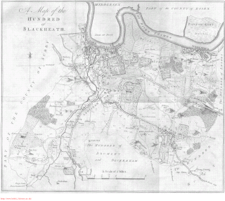
Blackheath was an ancient hundred in the north west of the county of Kent in England. It had become obsolete by the beginning of the 20th century in the wake of ongoing reforms to local government. The name "Blackheath" now refers to a district of SE London. In 2022, the area of the old hundred lies mainly within the Royal Borough of Greenwich.
