Royal Liberty of Havering

Last updated

Havering
Havering-atte-Bower
Area
  183112,550 acres (50.8 km2)
  189212,550 acres (50.8 km2)
Population
  18316,812
History
  Origin Hornchurch parish in the Becontree Hundred of Essex
  Created12th century
  Abolished1 July 1892
  Succeeded byReincorporated with Essex
Status Royal manor (11th century–1828)
Liberty (1465–1892)
GovernmentHavering Quarter Sessions
   HQ Court House, Market Place, Romford
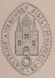
Liberty of havering seal.png
Seal of Havering
Subdivisions
  TypeChapelries (later became parishes)
  Units
  1. Romford
  2. Havering atte Bower
  3. Hornchurch
Havering liberty 1881.png
Three parishes of the liberty in 1881

Havering, also known as Havering-atte-Bower, was a royal manor and ancient liberty whose area now forms part of, and gives its name to, the London Borough of Havering in Greater London. The manor was in the possession of the Crown from the 11th to the 19th centuries and was the location of Havering Palace from the 13th to the late 17th century. [1] It occupied the same area as the ancient parish of Hornchurch which was divided into the three chapelries of Havering, Hornchurch and Romford.

Contents

History

Toponymy

The name Havering is recorded in the 1086 Domesday Book as "Haueringas" and means 'the settlement of the family or followers of a man called Hæfer', an ancient folk name. [2] From the 13th century the suffix -atte-Bower was added and means 'at the royal residence'. [2] The London Borough of Havering and the small settlement of Havering-atte-Bower continue to use these names.

Formation

Havering Palace, a resort house for hunting, was well established by the early 12th century. This suggests that the manor of Havering was in royal ownership prior to 1066, although the beginning of its association with royalty is unrecorded. [3] Havering was recorded as part of the Becontree hundred of Essex in the Domesday Book of 1086. The manor was held directly by the Crown, with the monarch acting as lord of the manor. Because they were not normally resident in Havering, and did not appoint a representative to act in their place, the residents of Havering enjoyed unusual autonomy. In 1251 Havering had a population of nearly 2,000. [4]

Liberty charters

A liberty was formed by charter for the manor of Havering in 1465. The charter issued in 1465 by King Edward IV reconfirmed many existing rights. The event was celebrated by the issue of a copper token for currency in the late 18th century, which uniquely among the many coins of that era bears the date 1465. The charter gave residents of the area freedom from taxation, its own local magistrates and gaol, and, earlier, freedom from the service of writs by the Essex Quarter Sessions. The famous Romford Market was another privilege that was guaranteed under this arrangement.

Governance

The government of the liberty was in the hands of a high steward, deputy steward, clerk of the peace and coroner. The high steward was chosen by the lord of the manor. The office of deputy steward was instituted by the 1465 charter, being appointed by the high steward. [5] The clerk of the peace and coroner were elected by the tenants and inhabitants of the liberty. In 1848 other officers of the corporation were a high bailiff, under bailiff, two head constables and nine petty constables. [6] Gallows Corner was used as the place of execution in the liberty.

The manor and liberty originally comprised the large ancient parish of Hornchurch which was divided into eight wards. By the 16th century 'Romford side' comprising the five northern wards of Romford Town, Harold Wood, Collier Row, Noak Hill, and Havering had achieved some degree of self-government. The remaining 'Hornchurch side' consisted of Hornchurch Town, North End, and South End wards. Hornchurch Town ward was absorbed into North End and South End around 1722. Havering ward grew independent of Romford in the 17th century and became a separate parish in the 1780s. [7] [8] In 1849 Romford became a parish in its own right. [1]

Replacement

The manor was sold by the Crown on 23 September 1828 and the right to appoint the high steward and justices of the liberty was transferred to the private owners. During the 19th century ad hoc boards, such as unions for poor law or public health, started to erode the powers of the liberty. It was unreformed by the Municipal Corporations Act 1835 and the Municipal Corporations Act 1883 made provision for the liberty to be absorbed into the county of Essex, but did not force the amalgamation. [1] Under the Local Government Act 1888 the property of the liberty was merged with that of the county, and the offices of high and deputy steward were no longer filled. The separate court of quarter sessions, limited to three justices, continued to exist, and a high bailiff and coroner continued to be appointed.

One of the three justices was elected by the inhabitants of the manor. The last election took place on 3 July 1891 at the market court house. The candidates were Major Holmes of Grey Towers, Hornchurch, and Alfred William Harvey of Romford. Holmes won the election with 78 votes to 42. [9]

On 21 October 1891 the Essex quarter sessions resolved "that a petition be presented to Her Majesty praying that an Order in Council be made to unite the Liberty of Havering-atte-Bower to the County of Essex, so far as the same is not already united by the Local Government Act, 1888." [10] The Order in Council, under the Liberties Act 1850, was made on 9 May 1892, and came into effect on 1 July 1892. The last high bailiff was paid a pension of £3 for life, while the coroner became a county employee. [11]

In 1894, under the Local Government Act 1894, the central part of the Romford parish, named Romford Urban formed the Romford Urban District while the remaining parts of the liberty went on to form part of Romford Rural District. The modern day London Borough of Havering, created in 1965, takes its name from the liberty and incorporates the original area and other territories formerly part of Chafford hundred, including North Ockendon, Rainham, Upminster, Cranham, and Wennington.

Legacy

Modern day references to the liberty include the Liberty Shopping Centre and Royal Liberty School. The motto of Havering London Borough Council is "Liberty". During 2024 the Romford–Upminster service of the London Overground was renamed the Liberty line. [12]

Geography

The liberty was partially bounded by rivers. To the south there was a short boundary with Erith in the Lessness hundred of Kent, formed by the River Thames. [13] To the east the River Ingrebourne formed a boundary with the Chafford hundred of Essex and the parishes of (from north to south) South Weald, Upminster and Rainham. To the north of the liberty was much higher ground and the boundary with the Ongar hundred and the parishes of (west to east) Lambourne, Navestock and Stapleford Abbotts. The western boundary was with the reduced Becontree hundred and the parish of Dagenham, partially formed by the River Beam. To the south the lower elevation formed the Hornchurch Marshes. The London to Colchester Roman Road (now the A12) cut through the liberty further north. In 1831 the total population of the liberty was 6,812.

Related Research Articles

<span class="mw-page-title-main">Cranham</span> A residential area of East London, England

Cranham is a residential area of east London, and part of the London Borough of Havering. It is located 17.5 miles (28 km) east-northeast of Charing Cross and comprises an extensive built-up area to the north and a low density conservation area to the south surrounded by open land. It was historically a rural village in the county of Essex and formed an ancient parish. It is peripheral to London, forming the eastern edge of the urban sprawl. The economic history of Cranham is characterised by a shift from agriculture to housing development. As part of the suburban growth of London in the 20th century, Cranham significantly increased in population, becoming part of Hornchurch Urban District in 1934 and has formed part of Greater London since 1965. The 2011 Census population of Cranham was included in Upminster.

<span class="mw-page-title-main">Harold Wood</span> Suburban neighbourhood in Havering, east London

Harold Wood is a suburban neighbourhood in East London in the London Borough of Havering. It is situated 16.5 miles (26.6 km) east-northeast of Charing Cross. Harold Wood was part of the ancient parish of Hornchurch, which became the Liberty of Havering. Most of the current area of Harold Wood became part of Hornchurch Urban District in 1926. It is near to the Greater London boundary with Essex.

<span class="mw-page-title-main">Hornchurch</span> Town in east London, England

Hornchurch is a suburban town in East London in the London Borough of Havering. It is located 15.2 miles (24.5 km) east-northeast of Charing Cross. It comprises a number of shopping streets and a large residential area. It historically formed a large ancient parish in the county of Essex that became the manor and liberty of Havering. The economic history of Hornchurch is underpinned by a shift away from agriculture to other industries with the growing significance of nearby Romford as a market town and centre of administration. As part of the suburban growth of London in the 20th century, Hornchurch significantly expanded and increased in population, becoming an urban district in 1926 and has formed part of Greater London since 1965. It is the location of Queen's Theatre, Havering Sixth Form College and Havering College of Further and Higher Education.

<span class="mw-page-title-main">Romford</span> Town in Greater London, England

Romford is a large town in East London, England, 14 miles (23 km) northeast of Charing Cross. Part of the London Borough of Havering, the town is one of the major metropolitan centres of Greater London identified in the London Plan.

<span class="mw-page-title-main">Upminster</span> Town in East London

Upminster is a suburban town in East London, England, within the London Borough of Havering. Located 16.5 miles (26.6 km) east-northeast of Charing Cross, it is one of the locally important district centres identified in the London Plan.

<span class="mw-page-title-main">London Borough of Havering</span> London borough in United Kingdom

The London Borough of Havering in East London, England, forms part of Outer London. It has a population of 259,552 inhabitants; the principal town is Romford, while other communities include Hornchurch, Upminster, Collier Row and Rainham. The borough is mainly suburban, with large areas of protected open space. Romford is a major retail and night time entertainment centre, and to the south the borough extends into the London Riverside redevelopment area of the Thames Gateway. The name Havering is a reference to the Royal Liberty of Havering which occupied the area for several centuries. The local authority is Havering London Borough Council. It is the easternmost London borough.

Ardleigh Green is an area in east London, England, within the London Borough of Havering. It is 15.5 miles (25 km) east-northeast of Charing Cross. This part of London is predominantly residential.

<span class="mw-page-title-main">Emerson Park</span> Suburban neighbourhood in East London

Emerson Park is a suburban neighbourhood in the London Borough of Havering, east London. The neighbourhood developed as two large housing estates built on the 550 acres (2.2 km2) estate of Nelmes manor in the parish of Hornchurch. Emerson Park estate to the south started construction in 1895 and Great Nelmes estate to the north was begun in 1901. It is located north of the Romford–Upminster line and a station opened at Emerson Park in 1909. The mansion of Nelmes survived until it was demolished in 1967 to avoid preservation by the Civic Amenities Act and was replaced with a small housing estate called The Witherings. Emerson Park is located 15 miles (24.1 km) northeast of Charing Cross in Central London.

<span class="mw-page-title-main">Harold Hill</span> Human settlement in England

Harold Hill is a suburban area in the London Borough of Havering, East London. 16.6 miles (26.7 km) northeast of Charing Cross. It is a district centre in the London Plan. The name refers to King Harold II, who held the manor of Havering-atte-Bower, and who was killed at the Battle of Hastings in 1066. The suburb is peripheral to London, forming an eastern edge of the urban sprawl.

<span class="mw-page-title-main">Havering-atte-Bower</span> Human settlement in London, England

Havering-atte-Bower is a village in Greater London, England, in the far north of the London Borough of Havering. The village lies 15 miles (24 km) northeast of Charing Cross. It was one of three former parishes whose area comprised the historic Royal Liberty of Havering.

<span class="mw-page-title-main">Romford Market</span> Large open market in Greater London

Romford Market is a large outdoor retail market located in Romford in the London Borough of Havering, England. The market right was established by royal order in 1247. Rival markets are prohibited within 6.66 miles (10.72 km). Governance of the market was strengthened by the 1465 charter of the Liberty of Havering, which was administered from a court house at the western end of the market. Formerly a livestock and agricultural market, cattle was last sold in 1958. The market has been in local authority ownership since it was purchased by the Romford Local Board in 1892 and is now owned by Havering Council. The marketplace was located on the main east–west road through the town until traffic was diverted away from the market in 1969. The market is promoted as a filming location. It is open on Wednesday, Friday and Saturday. There was a Sunday market from July 2020 to March 2024. As of July 2020 it has 60 licensed traders, down from a peak of over 300.

<span class="mw-page-title-main">Havering Palace</span> Former royal residence in England

Havering Palace was an old royal residence in England, in the village of Havering-atte-Bower. It was built before 1066 but abandoned in 1686. By 1816 no walls remained above ground.

<span class="mw-page-title-main">Romford (UK Parliament constituency)</span> Parliamentary constituency in the United Kingdom, 1885 onwards

Romford is a constituency in Greater London represented in the House of Commons of the UK Parliament since 2001 by Andrew Rosindell, a Conservative.

<span class="mw-page-title-main">Hornchurch Urban District</span>

Hornchurch was a local government district in southwest Essex from 1926 to 1965, formed as an urban district for the civil parish of Hornchurch. It was greatly expanded in 1934 with the addition of Cranham, Great Warley, Rainham, Upminster and Wennington; and in 1936 by gaining North Ockendon. Hornchurch Urban District Council was based at Langtons House in Hornchurch from 1929. The district formed a suburb of London and with a population peaking at 131,014 in 1961, it was one of the largest districts of its type in England. It now forms the greater part of the London Borough of Havering in Greater London.

<span class="mw-page-title-main">South Hornchurch</span> Human settlement in England

South Hornchurch is a locality to the south of Hornchurch in London Borough of Havering, east London. It is a suburban development situated 13.6 miles (21.8 km) east of Charing Cross. The area is a relatively recent addition, compared with the more mature suburbs in Havering. It was built on open farmland and the former site of RAF Hornchurch.

Romford Rural District was a local government district in southwest Essex, England from 1894 to 1934. It surrounded, but did not include, Romford which formed a separate urban district. During the life of the district the area changed in use from rural farm land to sprawling London suburb and in 1926 much of it was removed to form new urban districts.

<span class="mw-page-title-main">Becontree Hundred</span> Former administrative division of Essex, England

Becontree was an ancient hundred in the south west of the county of Essex, England. Its area has been entirely absorbed by the growth of London; with its name reused in 1921 for the large Becontree estate of the London County Council. Its former area now corresponds to the London Borough of Newham, the London Borough of Barking and Dagenham and parts of the London Borough of Waltham Forest and the London Borough of Redbridge. Its early extent also included parts of what is now the London Borough of Havering.

<span class="mw-page-title-main">Rainham, London</span> Suburb of East London, England

Rainham is a suburb of East London, England, in the London Borough of Havering. Historically an ancient parish in the county of Essex, Rainham is 13.6 miles (21.9 km) east of Charing Cross and is surrounded by a residential area, which has grown from the historic village, to the north and a commercial area, fronting the River Thames, to the south. As part of the suburban growth of London in the 20th century, Rainham significantly expanded and increased in population, becoming part of Hornchurch Urban District in 1934, and has formed part of Greater London since 1965. The economic history of Rainham is underpinned by a shift from agriculture to industry and manufacture and is now in a period of regeneration, coming within the London Riverside section of the Thames Gateway redevelopment area.

<span class="mw-page-title-main">Marks (manor house)</span> Former manor house in London, England

Marks was a manor house located near Marks Gate at the northern tip of the London Borough of Barking and Dagenham in London, England, the house standing on what is now Warren Hall Farm, about two miles west of Romford. The name Marks is believed to have been derived from the de Merk family who built the original manor in the 14th century. The manor house was demolished in 1808.

References

  1. 1 2 3 "The liberty of Havering-atte-Bower". A History of the County of Essex: Volume 7. 1978. Retrieved 21 March 2008.
  2. 1 2 Mills, D. (2000). Oxford Dictionary of London Place Names.
  3. McIntosh 1986 , p. 8
  4. McIntosh 1986 , p. 1
  5. The People's History of Essex, Chelmsford, 1861
  6. The Parliamentary Gazetteer of England and Wales, Vol. II, 1848, p.288
  7. 'Hornchurch: Economic history and local government', A History of the County of Essex: Volume 7 (1978), pp. 39–45. URL: http://www.british-history.ac.uk/report.aspx?compid=42811 Date accessed: 28 August 2012
  8. 'Romford: Introduction', A History of the County of Essex: Volume 7 (1978), pp. 56–64. URL: http://www.british-history.ac.uk/report.aspx?compid=42815 Date accessed: 28 August 2012.
  9. The Times, July 4, 1891
  10. The Essex Review, January 1892 (transcription at Essexpast.co.uk), accessed 26 March 2008
  11. London Gazette, issue 26287, published 13 May 1892
  12. Cairns, Dan (15 February 2024). "London Overground: Six new rail line names and colours revealed in rebrand". Sky News. Retrieved 15 February 2024.
  13. "The hundred of Becontree: Introduction". A History of the County of Essex: Volume 5. 1966. Retrieved 11 January 2008.

Sources