Municipal Borough of Walthamstow

Last updated

Walthamstow
Walthamstow Town Hall 20 Apr 2006.jpg
Walthamstow essex 1961.png
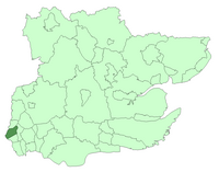
Walthamstow within Essex in 1961
Area
  19114,343 acres (17.58 km2) [1]
  1931/19614,342 acres (17.57 km2) [1]
Population
  1911124,580 [1]
  1931132,972 [1]
  1961108,845 [1]
Density
  191128.7/acre
  193130.7/acre
  196125.1/acre
History
  OriginWalthamstow ancient parish (excluding Walthamstow Slip)
  Created1873
  Abolished1965
  Succeeded by London Borough of Waltham Forest
Status Local board district (1873–1894)
Urban district (1894–1929)
Municipal borough (1929–1965)
GovernmentWalthamstow Local Board (1873–1894)
Walthamstow Urban District Council (1894–1929)
Walthamstow Borough Council (1929–1965)
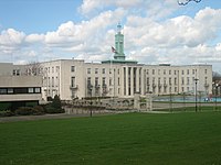
   HQ Town Hall, Orford Road (1876–1941)
Town Hall, Forest Road (1941–1965)
   Motto Fellowship is life
Arms-walthamstow.jpg
Coat of arms of the borough council

Walthamstow was a local government district in southwest Essex, England from 1873 to 1965, around the town of Walthamstow. It was within the London suburbs, forming part of the London postal district and Metropolitan Police District. Its former area now corresponds to the central part of the London Borough of Waltham Forest in Greater London. Its population and area grew rapidly as London continued to develop its suburbs. [2]

Contents

Background and formation

The ancient parish of Walthamstow formed part of the Becontree hundred of Essex. It was grouped into the West Ham poor law union in 1837 and included in the Metropolitan Police District in 1840.

The Public Health Act 1872 would have transferred sewerage and sanitary powers from the Walthamstow Vestry to the West Ham Board of Guardians. To avoid this, the parish adopted the Local Government Act 1858 in 1873 and was constituted as a local board district, [3] governed by a local board, replacing the vestry, and special drainage district that had been created in 1868 for the southeast of the parish. The local board became the urban sanitary authority in 1875. Under the Local Government Act 1894 it became an urban district, governed by Walthamstow Urban District Council as London continued to grow its suburbs.

Geography

The parish of Walthamstow included a long and narrow exclave of 98 acres in Leyton known as "Walthamstow Slip". It became part of the Leyton local government district in 1873 when a local board was created and was merged with the Leyton civil parish on 1 December 1877. [4]

Incorporation

The incorporation of the parish of Walthamstow as a municipal borough was publicly discussed in 1892 (the population at the 1891 census was 46,346). In 1907 and 1908 the possibility of transfer to the County of London was considered by Walthamstow Urban District Council, which would have converted the urban district into a metropolitan borough (1911 population was 124,580). After the First World War the Walthamstow Guardian led a campaign to have the district incorporated and a petition was submitted to the privy council in 1920. The decision was delayed until 1926 by the Royal Commission on London Government. The council had been supplying electricity to the district since 1895 and during the General Strike of 1926 cut off the supply to factories. Following the strike, the council was found to be in neglect of duty and this led to the delay of the official grant of borough status until 1929. [3] The charter of incorporation was presented by James Henry Thomas, Lord Privy Seal. [5] The first mayor was Sir Courtenay Warner.

Civic works and services

There was a burial board from 1870 to 1896, when the functions were absorbed by Walthamstow Urban District Council.

There was a Walthamstow School Board from 1880 to 1903 responsible for elementary education. Following the Education Act 1902 this power was transferred to Essex County Council. However, thanks to the rapid suburban development of London, the population of Walthamstow was high enough, therefore it was permitted to take over responsibility from the school board for elementary education. This right continued after the Education Act 1944.

The borough ran its own tram services until they became the responsibility of the London Passenger Transport Board in 1933. [6]

Walthamstow Town Hall was built on Orford Road in 1876. A new Town Hall was built in Forest Road in 1941. [7]

Abolition

Walthamstow formed part of the review area of the Royal Commission on Local Government in Greater London. The report of the commission proposed that Walthamstow should be combined with Chingford to form one of 52 boroughs in Greater London. Following the London Government Act 1963 in 1965 the borough was abolished and transferred from Essex to Greater London. It was combined with the former boroughs of Chingford and Leyton to form the present-day Waltham Forest, one of 32 London boroughs.

Related Research Articles

<span class="mw-page-title-main">Chingford</span> Human settlement in England

Chingford is a town in east London, England, within the London Borough of Waltham Forest. The centre of Chingford is 9.2 miles (14.8 km) north-east of Charing Cross, with Waltham Abbey to the north, Woodford Green and Buckhurst Hill to the east, Walthamstow to the south, and Edmonton and Enfield to the west.

<span class="mw-page-title-main">Leyton</span> Town in east London, England

Leyton is a town in east London, England, within the London Borough of Waltham Forest. It borders Walthamstow to the north, Leytonstone to the east, and Stratford to the south, with Clapton, Hackney Wick and Homerton, across the River Lea, to the west. The area includes New Spitalfields Market, Leyton Orient Football Club, as well as part of the Queen Elizabeth Olympic Park. The town consists largely of terraced houses built between 1870 and 1910, interspersed with some modern housing estates. It is 6.2 miles (10 km) north-east of Charing Cross.

<span class="mw-page-title-main">Walthamstow</span> Suburb of London, England

Walthamstow is a town in the London Borough of Waltham Forest, around 7.5 miles (12 km) northeast of Central London. The town borders Chingford to the north, Snaresbrook and South Woodford to the east, Leyton and Leytonstone to the south, and Tottenham to the west. At the 2011 census, the town had a population of approximately 109,424.

<span class="mw-page-title-main">London Borough of Waltham Forest</span> London borough in United Kingdom

The London Borough of Waltham Forest is an outer London borough formed in 1965 from the merger of the municipal boroughs of Leyton, Walthamstow and Chingford.

<span class="mw-page-title-main">Epping Forest District</span> Non-metropolitan district in England

Epping Forest District is a local government district in Essex, England. It is named after the ancient woodland of Epping Forest, a large part of which lies within the district. The council is based in the town of Epping. The district also includes the towns of Loughton, Waltham Abbey, Chigwell, Buckhurst Hill, as well as rural areas. The district is situated in the west of the county, bordering north-eastern Greater London.

<span class="mw-page-title-main">Buckhurst Hill</span> Human settlement in England

Buckhurst Hill is a suburban village in the Epping Forest district of Essex, England. It is part of the Greater London Urban Area and adjacent to the northern boundary of the London Borough of Redbridge. The area developed following the opening of a railway line in 1856, originally part of the Eastern Counties Railway and now on the Central line of the London Underground.

<span class="mw-page-title-main">Sewardstone</span> Human settlement in England

Sewardstone is a hamlet in the parish of Waltham Abbey, in the Epping Forest District of Essex, England. It is located south of the main built-up area of Waltham Abbey, lying between Epping Forest, Chingford and Enfield. It is 11.6 miles north-northeast of Central London and is in the London commuter belt.

<span class="mw-page-title-main">Waltham Holy Cross Urban District</span>

Waltham Holy Cross was a local government district in the county of Essex, England. It was created as a local board of health district in 1850 when the parish of Waltham Holy Cross adopted the Public Health Act 1848 and was governed by Waltham Holy Cross Local Board of Health. In 1894 it became an urban district and the board became Waltham Holy Cross Urban District Council.

<span class="mw-page-title-main">Waltham Abbey</span> Human settlement in England

Waltham Abbey is a town and civil parish in the Epping Forest District of Essex, within the metropolitan and urban area of London, England, 13.5 miles (21.7 km) north-east of Charing Cross. It lies on the Greenwich Meridian, between the River Lea in the west and Epping Forest in the east, with large sections forming part of the Metropolitan Green Belt.

<span class="mw-page-title-main">History of Essex</span> Aspect of history

Essex is a county in the East of England which originated as the ancient Kingdom of Essex and one of the seven kingdoms, or heptarchy, that went on to form the Kingdom of England.

<span class="mw-page-title-main">East London</span> Northeastern part of London, United Kingdom

East London is the northeastern part of London, England, east of the ancient City of London and north of the River Thames as it begins to widen. East London developed as London's docklands and the primary industrial centre. The expansion of railways in the 19th century encouraged the eastward expansion of the East End of London and a proliferation of new suburbs. The industrial lands of East London are today an area of regeneration, which are well advanced in places such as Canary Wharf and ongoing elsewhere.

<span class="mw-page-title-main">Municipal Borough of Chingford</span>

Chingford was a local government district in south west Essex, England from 1894 to 1965, around the town of Chingford. It was within the London suburbs, forming part of the London postal district and Metropolitan Police District. Its former area now corresponds to the northern part of the London Borough of Waltham Forest in Greater London.

<span class="mw-page-title-main">Municipal Borough of Leyton</span>

Leyton was a local government district in southwest Essex, England, from 1873 to 1965. It included the neighbourhoods of Leyton, Leytonstone and Cann Hall. It was suburban to London, forming part of the London postal district and Metropolitan Police District. It now forms the southernmost part of the London Borough of Waltham Forest in Greater London.

<span class="mw-page-title-main">London Government Act 1963</span> United Kingdom legislation

The London Government Act 1963 is an act of the Parliament of the United Kingdom, which created Greater London and a new local government structure within it. The Act significantly reduced the number of local government districts in the area, resulting in local authorities responsible for larger areas and populations. The upper tier of local government was reformed to cover the whole of the Greater London area and with a more strategic role; and the split of functions between upper and lower tiers was recast. The Act classified the boroughs into inner and outer London groups. The City of London and its corporation were essentially unreformed by the legislation. Subsequent amendments to the Act have significantly amended the upper tier arrangements, with the Greater London Council abolished in 1986, and the Greater London Authority introduced in 2000. As of 2016, the London boroughs are more or less identical to those created in 1965, although with some enhanced powers over services such as waste management and education.

Romford Rural District was a local government district in southwest Essex, England from 1894 to 1934. It surrounded, but did not include, Romford which formed a separate urban district. During the life of the district the area changed in use from rural farm land to sprawling London suburb and in 1926 much of it was removed to form new urban districts.

Epping was a parliamentary constituency represented in the House of Commons of the UK Parliament from 1885 to 1974. It elected one Member of Parliament (MP) by the first past the post system of election.

<span class="mw-page-title-main">London Traffic Area</span>

The London Traffic Area was established by the London Traffic Act 1924 to regulate the increasing amount of motor traffic in the London area. The LTA was abolished in 1965 on the establishment of the Greater London Council.

<span class="mw-page-title-main">Waltham Forest London Borough Council</span>

Waltham Forest London Borough Council is the local authority for the London Borough of Waltham Forest in London, England which has existed since the London Government Act 1963 was commenced in 1965, replacing three local authorities: Chingford Borough Council, Leyton Borough Council and Walthamstow Borough Council. It is one of London's 32 borough councils, divided into 20 wards and elects 60 councillors.

The Royal Commission on Local Government in Greater London, also known as the Herbert Commission, was established in 1957 and published its report in 1960. The report made recommendations for the overhaul of the administration of the capital. They were modified and implemented by the London Government Act 1963.

<span class="mw-page-title-main">Woodford, London</span> Human settlement in England

Woodford is a town in East London, within the London Borough of Redbridge. It is located 9.5 miles (15.3 km) north-east of Charing Cross. Woodford historically formed an ancient parish in the county of Essex. It contained a string of agrarian villages and was part of Epping Forest. From about 1700 onwards, it became a place of residence for affluent people who had business in London; this wealth, together with its elevated position, has led to it being called the Geographical and social high point of East London. Woodford was suburban to London and after being combined with Wanstead in 1934 it was incorporated as a municipal borough in 1937. It has formed part of Greater London since 1965 and comprises the neighbourhoods of Woodford Green, Woodford Bridge, Woodford Wells and South Woodford. The area is served by two stations on the Central line of the London Underground: Woodford and South Woodford.

References

  1. 1 2 3 4 5 Great Britain Historical GIS / University of Portsmouth, Walthamstow UD/MB  population  (area and density). Retrieved 2008-02-13.
  2. Great Britain Historical GIS / University of Portsmouth, Walthamstow UD/MB  ( historic map ). Retrieved 2008-02-13.
  3. 1 2 Powell, W R (1973). "'Walthamstow: Local government and public services', in A History of the County of Essex". London: British History Online. pp. 275–285. Retrieved 15 September 2020.
  4. "Leyton CP/AP through time | Census tables with data for the Parish-level Unit". Visionofbritain.org.uk. Retrieved 11 May 2020.
  5. "London's New Borough - British Pathé". Britishpathe.com. 8 May 2014. Retrieved 11 May 2020.
  6. Reed, J., London Tramways, (1997)
  7. A History of the County of Essex: Volume 6. Victoria County History.
The old town hall in Orford Road Walthamstow Old Town Hall - geograph.org.uk - 1463183.jpg
The old town hall in Orford Road

51°35′27″N0°0′48″W / 51.59083°N 0.01333°W / 51.59083; -0.01333