Municipal Borough of Bromley

Last updated

Bromley
Bromley Town Hall.jpg
Bromley Town Hall
Bromley borough map 1961.png
Bromley within Kent in 1961
Area
  18714,706 acres (19.04 km2) [1]
  19114,696 acres (19.00 km2) [2]
  19616,513 acres (26.36 km2) [3]
Population
  187110,764 [1]
  191127,397 [2]
  196168,252 [3]
Density
  18712.3/acre
  19115.8/acre
  196110.5/acre
History
  Created1867
  Abolished1965
  Succeeded by London Borough of Bromley
Status Local board (1867 - 1894)
Urban district (1894 - 1903)
Municipal borough (after 1903)
Government
   HQ Bromley Town Hall
   Motto Dum Cresco Spero (While I grow I hope)
Arms-bromley-bc.jpg
Coat of arms

Bromley was a local government district in northwest Kent from 1867 to 1965 around the town of Bromley. The area was suburban to London's conurbation area. It didn't form part of the London Postal District but it formed part of the Metropolitan Police District and from 1933 was included in the area of the London Passenger Transport Board.

Contents

History

Local board and urban district

Bromley Local Government District was formed in 1867 when the parish of Bromley adopted the Local Government Act 1858, and a local board of twelve members was formed to govern the town. [1] The Local Government Act 1894 reconstituted the area as Bromley Urban District. An urban district council of 16 members replaced the local board. [4]

Incorporation

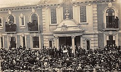
The town was granted a charter of incorporation to become a municipal borough in 1903. The granting of the charter was celebrated by a public holiday in the town on 2 September 1903. The charter was brought by train to Bromley South station where it was handed to the charter mayor. The mayor then rode in procession led by units of the Royal Horse Artillery and the Royal West Kent Regiment, accompanied by mayors and mace bearers of boroughs in Kent and the County of London and watched by an estimated crowd of 20,000. A sports day and carnival was held at Queen's Mead. [5]

Under the charter a town council consisting of a mayor, six aldermen and eighteen councillors replaced the UDC. [6]

The council was initially based at the old Town Hall in the Market Square but moved to a new Town Hall in Tweedy Road in 1907. [7]

Boundary changes

The area of the borough was increased in 1934, when a county review order added parts of the abolished Bromley Rural District (Hayes and part of Keston). [8] The council was subsequently enlarged to seven aldermen and twenty-one councillors.

In 1965 the municipal borough was abolished by the London Government Act 1963 and its former area transferred to Greater London from Kent. Its former area was combined with that of other districts to form the present-day London Borough of Bromley.

Borough council

The borough council was initially controlled by independents, with a handful of Labour party councillors forming an opposition group. There was a single Communist councillor from 1945 to 1947. [9] The Conservative Party began to contest elections in 1947, and gained a majority in 1950. [9] [10] At the final election prior to abolition the Conservatives lost their overall majority with 14 councillors and aldermen against 6 independents, 4 Labour and 4 Liberal members. [11]

Coat of arms

Armorial bearings were granted to the borough by the College of Arms on 19 April 1904. The blazon was as follows: [12]
Quarterly gules and azure, on a fesse wavy argent three ravens volant paroper, between in the first quarter two branches of broom slipped of the third, in the second a sun in splendour, in the third an escallop shell or, and in the fourth a horse forcene argent. Crest: On a wreath of the colours, upon two bars wavy azure and argent, an escallop shell as in the arms, between two branches of broom proper.
The sprigs of broom were in allusion to the name "Bromley". The silver wave bearing three ravens represented the River Ravensbourne, while the sun was for Sundridge. The scallop shell was derived from the arms of the diocese of Rochester, granted the manor of Bromley at the time of King Ethelbert. The arms were completed by a white rearing horse, the emblem of Kent. [13]

The Latin motto adopted by the council was Dum Cresco Spero or "While I grow I hope".

Notable people

▪︎Philip Hollobone

Related Research Articles

<span class="mw-page-title-main">Metropolitan Borough of Hackney</span>

The Metropolitan Borough of Hackney was a metropolitan borough of the County of London from 1900 to 1965. Its area became part of the London Borough of Hackney.

<span class="mw-page-title-main">Municipal borough</span> Former type of British and Irish local government

A municipal borough was a type of local government district which existed in England and Wales between 1835 and 1974, in Northern Ireland from 1840 to 1973 and in the Republic of Ireland from 1840 to 2002. Broadly similar structures existed in Scotland from 1833 to 1975 with the reform of royal burghs and creation of police burghs.

<span class="mw-page-title-main">County Borough of Croydon</span>

The County Borough of Croydon was a local government district in and around the town of Croydon in north east Surrey, England from 1889 to 1965. Since 1965 the district has been part of the London Borough of Croydon within Greater London.

<span class="mw-page-title-main">Municipal Borough of Finchley</span>

Finchley, which is now in north London, was a local government district in Middlesex, England, from 1878 to 1965. Finchley Local Board first met in 1878. It became Finchley Urban District Council in 1895 and the Municipal Borough of Finchley in 1933. In 1965 Middlesex was abolished and Finchley became part of the London Borough of Barnet.

<span class="mw-page-title-main">Municipal Borough of Bexley</span> Abolished 1965

Bexley was a local government district in north west Kent from 1879 to 1965 around the town of Old Bexley.

<span class="mw-page-title-main">Municipal Borough of Acton</span>

Acton was a local government district in Middlesex, England from 1865 to 1965.

<span class="mw-page-title-main">Municipal Borough of Ealing</span>

Ealing was a local government district from 1863 to 1965 around the town of Ealing which formed part of the built up area of London until 1965, where it became part of Greater London.

<span class="mw-page-title-main">Municipal Borough of Southall</span>

Southall was a local government district in the county of Middlesex, United Kingdom from 1891 to 1965. It consisted of the civil parish of Norwood.

<span class="mw-page-title-main">Municipal Borough of Enfield</span>

Enfield was a local government district in Middlesex, England from 1850 to 1965.

<span class="mw-page-title-main">Municipal Borough of Beddington and Wallington</span>

Beddington and Wallington was, from 1915 to 1965, a local government district in north east Surrey, England. It formed part of the London suburbs, lying within the Metropolitan Police District and the London Passenger Transport Area. In 1965 it was abolished on the creation of Greater London.

<span class="mw-page-title-main">County Borough of Salford</span> Former district of England

Salford was, from 1844 to 1974, a local government district in the county of Lancashire in the northwest of England, covering the city of Salford. It was granted city status in 1926.

<span class="mw-page-title-main">City and County of Swansea Council</span> Local government of Swansea

The City and County of Swansea Council, or simply Swansea Council, is the local authority for the city and county of Swansea, one of the principal areas of Wales. The principal area also includes rural areas to the north of the built-up area of Swansea and the Gower Peninsula to the west. The council consists of 75 councillors representing 32 electoral wards.

<span class="mw-page-title-main">County Borough of Oldham</span>

Oldham was, from 1849 to 1974, a local government district in the northwest of England coterminous with the town of Oldham.

<span class="mw-page-title-main">Municipal Borough of Sale</span>

Sale was, from 1867 to 1974, a district in Cheshire, England. The district had in turn the status of local government district, urban district and municipal borough. Its area now forms part of the Metropolitan Borough of Trafford, Greater Manchester.

<span class="mw-page-title-main">Municipal Borough of Stretford</span>

Stretford was, from 1868 to 1974, a local government district coterminate with the town of Stretford, Lancashire, England.

<span class="mw-page-title-main">County Borough of Rochdale</span>

Rochdale was, from 1856 to 1974, a local government district coterminate with the town of Rochdale in the northwest of England.

<span class="mw-page-title-main">County Borough of Bury</span>

Bury was a local government district centred on Bury in the northwest of England from 1846 to 1974.

<span class="mw-page-title-main">Municipal Borough of Middleton</span>

The Municipal Borough of Middleton was, from 1886 to 1974, a municipal borough in the administrative county of Lancashire, England, coterminous with the town of Middleton.

<span class="mw-page-title-main">Municipal Borough of Heywood</span>

The Municipal Borough of Heywood was, from 1881 to 1974, a local government district in the administrative county of Lancashire, England, with borough status and coterminate with the town of Heywood.

<span class="mw-page-title-main">County Borough of Carlisle</span>

Carlisle was, from 1835 to 1974, a local government district in the northwest of England, coterminate with Carlisle. In 1835, following the Municipal Corporations Act 1835, Carlisle was constituted a municipal borough of Cumberland, but was promoted to county borough status in 1914, within its boundaries taking over the functions of Cumberland County Council. The district was abolished on 31 March 1974 by the Local Government Act 1972.

References

  1. 1 2 3 "Bromley". Kelly's Directory of Kent, Surrey & Sussex. 1891. Retrieved 19 June 2008.
  2. 1 2 "1991 Census". Vision of Britain. 1911. Retrieved 19 June 2008.
  3. 1 2 "1961 Census". Vision of Britain. 1961. Retrieved 19 June 2008.
  4. "Bromley". Kelly's Directory of Kent. 1903. Retrieved 19 June 2008.
  5. "The Incorporation of Bromley". The Times . 3 September 1903. p. 8.
  6. "Bromley". Kelly's Directory of Kent. 1913. Retrieved 19 June 2008.
  7. "Former Bromley Town Hall". London Borough of Bromley. Retrieved 28 April 2020.
  8. "Relations / unit history of Bromley". Vision of Britain. Archived from the original on 30 September 2007. Retrieved 19 June 2008.
  9. 1 2 Municipal Elections, The Times, November 2, 1947, p.8
  10. The Municipal Elections, The Times, May 12, 1950, p.4
  11. Election Results in the Boroughs, The Times, May 10, 1963
  12. A C Fox-Davies, The Book of Public Arms, 2nd edition, London, 1915
  13. C Wilfrid Scott-Giles, Civic Heraldry of England and Wales, 2nd edition, London, 1953

51°24′N0°1′E / 51.400°N 0.017°E / 51.400; 0.017