Municipal Borough of Wembley

Last updated

Wembley
Brent Town Hall (Front), Wembley - geograph.org.uk - 865102.jpg
Former Brent Town Hall in Wembley
Wembley1961.svg
Wembley within Middlesex in 1961
History
  Created1894
  Abolished1965
  Succeeded by London Borough of Brent
Status Urban district (until 1937)
Municipal borough (from 1937)
Government
   HQ Brent Town Hall
   Motto Tempori Parendum (We must move with the times)
Coat of Arms Municipal Borough of Wembley.svg
Coat of Arms [1]

Wembley was an urban district and later a municipal borough in Middlesex, England from 1894 to 1965. [2]

History

Wembley Urban District was created by the Local Government Act 1894 from part of the existing Hendon Rural Sanitary District, and originally consisted of two civil parishes: Kingsbury and Wembley (formed from the Alperton, south Kenton, Preston, Sudbury and Wembley areas of the parish of Harrow on the Hill). The urban district council had twelve councillors: nine elected for Wembley parish and three for Kingsbury. [3]

In 1900 Kingsbury was constituted a separate urban district, and Wembley UD was reduced to nine councillors. In 1927 the urban district was divided into six wards: Alperton, Sudbury, Kenton, Wembley Central, Wembley Hill, and Wembley Park. The number of councillors was increased to 21. [3]

In 1934 a county review order reorganised the county districts of Middlesex, and Kingsbury Urban District was absorbed by Wembley UD. The enlarged Wembley Urban District had 12 wards. Of these, eight came from the area of the former Wembley UD (Alperton, Kenton, Tokyngton, Preston, Sudbury, Sudbury Court, Wembley Central, Wembley Park), and four from that of Kingsbury UD (Chalkhill, Fryent, The Hyde, and Roe Green). [3] [4]

In 1937 the urban district was granted a charter of incorporation and became a municipal borough. A corporation consisting of a mayor, 12 aldermen and 36 councillors replaced the urban district council. [3] A coat of arms was granted on 25 January 1938. It was composed of a green shield, representing the greenery of the borough, flanked by two lions, representing John Lyon, founder of Harrow School, whose home was at Preston Manor in Wembley. Each of the lions bears a flag; one depicts a balance and the other a cornucopia, or horn of plenty. Atop the shield is a crown, and beneath is a banner with the Latin words "Tempori Parendvm". [5]

The borough was abolished in 1965 by the London Government Act 1963 and its former area was merged with that of the neighbouring Municipal Borough of Willesden to form the London Borough of Brent. Brent Town Hall was originally built for the newly incorporated Municipal Borough of Wembley in the late 1930s. [6]

Related Research Articles

<span class="mw-page-title-main">Kingsbury, London</span> Human settlement in England

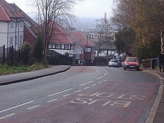
Kingsbury is a district of northwest London in the London Borough of Brent. Its ancient scope stretches to include various distinct areas that were once small villages until the inter-war period. Kingsbury was in 2001 a ward and in 2011 was identifiable with the Fryent and Barnhill wards approximately. Today it forms a quiet suburb between Fryent Country Park to the west and the Brent Reservoir to the east, along with a Jubilee line tube station and accompanying shopping district on the western side. The postal district is NW9 which it shares with Colindale and West Hendon.

<span class="mw-page-title-main">London Borough of Brent</span> London borough in United Kingdom

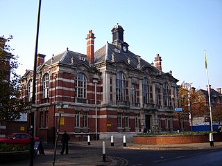
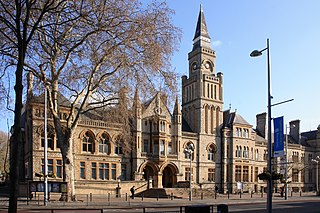
Brent is a borough in north-west London, England. It is known for landmarks such as Wembley Stadium, the Swaminarayan Temple and the Kiln Theatre. It also contains the Welsh Harp reservoir and the Park Royal commercial estate. The local authority is Brent London Borough Council.

<span class="mw-page-title-main">Wembley</span> Suburb of London

Wembley is a large suburb in the London Borough of Brent, north-west London, 8 miles (13 km) northwest of Charing Cross. It includes the neighbourhoods of Alperton, North Wembley, Preston, Sudbury, Tokyngton and Wembley Park. The population was 102,856 in 2011.

<span class="mw-page-title-main">London Borough of Harrow</span> London borough in United Kingdom

The London Borough of Harrow is a London borough in northwest London, England; it forms part of Outer London. It borders four other London boroughs – Barnet to the east of ancient Watling Street, Brent to the southeast, Ealing to the south and Hillingdon to the west – plus the Hertfordshire districts of Three Rivers and Hertsmere to the north. The local authority is Harrow London Borough Council. The London borough was formed in 1965, based on boundaries that had been established in 1934. The borough is made up of three towns: Harrow, Pinner and Stanmore, but also includes western parts of Edgware.

<span class="mw-page-title-main">Municipal Borough of Barnes</span>

Barnes was a local government district in north west Surrey from 1894 to 1965, when its former area was absorbed into the London Borough of Richmond upon Thames.

<span class="mw-page-title-main">Municipal Borough of Hendon</span> Former local authority in Middlesex, England

Hendon was an ancient civil parish of around 8,250 acres (33 km2) which included Mill Hill on the border of Hertfordshire, as well as Golders Green and Childs Hill on the border of what became the County of London. In 1894 it was created an urban district of Middlesex and in 1932 it became a municipal borough. The municipal borough was abolished in 1965 and the area became part of the London Borough of Barnet.

<span class="mw-page-title-main">Brent North (UK Parliament constituency)</span> UK Parliament constituency in England since 1974

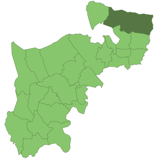
Brent North is a constituency represented in the House of Commons of the UK Parliament since 1997 by Barry Gardiner of the Labour Party.

<span class="mw-page-title-main">East Barnet Urban District</span>

East Barnet Valley was a local government district from 1863 to 1965 around the town of East Barnet. It was partly in the counties of Hertfordshire and Middlesex until 1889, when the Middlesex part was transferred to Hertfordshire. It was renamed East Barnet in 1935.

<span class="mw-page-title-main">Municipal Borough of Willesden</span> Former district in Middlesex, England

Willesden was a local government district in the county of Middlesex, England from 1874 to 1965. It formed part of the Metropolitan Police District and London postal district. Willesden was part of the built-up area of London and bordered the County of London to the east and south.

<span class="mw-page-title-main">Municipal Borough of Tottenham</span>

Tottenham was a local government district in north east Middlesex from 1850 to 1965. It was part of the London postal district and Metropolitan Police District.

<span class="mw-page-title-main">Municipal Borough of Acton</span>

Acton was a local government district in Middlesex, England from 1865 to 1965.

<span class="mw-page-title-main">Municipal Borough of Ealing</span>

Ealing was a local government district from 1863 to 1965 around the town of Ealing which formed part of the built up area of London until 1965, where it became part of Greater London.

<span class="mw-page-title-main">Municipal Borough of Southall</span>

Southall was a local government district in the county of Middlesex, United Kingdom from 1891 to 1965. It consisted of the civil parish of Norwood.

<span class="mw-page-title-main">Municipal Borough of Enfield</span>

Enfield was a local government district in Middlesex, England from 1850 to 1965.

<span class="mw-page-title-main">Municipal Borough of Edmonton</span>

Edmonton was a local government district in north-east Middlesex, England, from 1850 to 1965.

<span class="mw-page-title-main">Municipal Borough of Twickenham</span>

Twickenham was a local government district in Middlesex, England from 1868 to 1965.

<span class="mw-page-title-main">Sudbury, London</span> Human settlement in England

Sudbury is a suburb in the London Borough of Brent, located in northwest London, United Kingdom. The suburb forms the western part of Wembley and is centred around 0.6 miles (1 km) west of Wembley Central railway station.

<span class="mw-page-title-main">Roxeth</span> Human settlement in England

Roxeth was a hamlet in the ancient Harrow on the Hill parish, which now forms part of the London Borough of Harrow in Greater London, England.

<span class="mw-page-title-main">Coat of arms of the London Borough of Brent</span>

The Coat of arms of the London Borough of Brent is the official arms of the London Borough of Brent. It was granted on 1 September 1965.

The 1968 Brent Council election took place on 9 May 1968 to elect members of Brent London Borough Council in London, England. The whole council was up for election and the Conservative Party gained overall control of the council.

References

  1. "Wembley – Coat of arms (crest) of Wembley". Heraldry of the World. Retrieved 10 August 2022.
  2. Vision of Britain – Wembley UD/MB Archived 1 October 2007 at the Wayback Machine
  3. 1 2 3 4 Harrow, including Pinner – Local Government, Victoria County history of Middlesex, Vol.4 (British History Online), accessed 28 January 2008
  4. Kingsbury – Local Government in Victoria County History of Middlesex, Vol.5, accessed 28 January 2008
  5. The coat of arms of Wembley
  6. Barrès-Baker, M.C. "A Brief Architectural History of Wembley (later Brent) Town Hall" (PDF). Brent Archives. Retrieved 5 April 2020.

51°33′58″N0°16′27″W / 51.5661°N 0.2741°W / 51.5661; -0.2741