Municipal Borough of Enfield

Last updated

Enfield
Enfield1961.svg
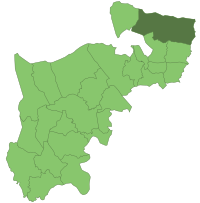
Enfield within Middlesex in 1961
Area
  191112,601 acres (50.99 km2)
  196112,400 acres (50 km2)
Population
  190142,378
  1961109,542
History
  Created1850
  Abolished1965
  Succeeded byLondon Borough of Enfield
Status Local board (1850 - 1894)
Urban district (1894 - 1955)
Municipal borough (from 1955)
Government
   HQ Little Park, Gentleman's Row 1888 - 1961
Civic Centre, Silver Street 1961 - 1965
   Motto Priora Cole Meliora Sequere (Cherish the past but strive after even better things in the future)
Coat of arms of the Municipal Borough of Enfield.svg
Coat of Arms

Enfield was a local government district in Middlesex, England from 1850 to 1965.

Contents

History

The parish of Enfield adopted the Public Health Act 1848 (11 & 12 Vict. c. 63) in 1850, and formed a local board of health of 12 members to govern the area. The local board's area was reconstituted by the Local Government Act 1894, and became Enfield Urban District. [1] Enfield Urban District Council replaced the local board, and was divided into four wards each returning three councillors: Town, Chase & Bull's Cross, Ordnance and Green Street & Ponders End. [2] In 1909 two new wards, Bush Park and Hadley Wood & Cockfosters were formed and the UDC increased to 18 councillors. [3]

The urban district council successfully petitioned for a charter of incorporation in 1955, becoming a municipal borough, with a corporation consisting of a mayor, ten aldermen and thirty councillors replacing the urban district council. The municipal borough was divided into ten wards, each returning three councillors: Bush Hill Park, Cambridge Road, Chase, Enfield Wash, Green Street, Ordnance, Ponders End, Town, West and Willow. [1]

The borough was abolished under the London Government Act 1963 was merged with the Municipal Borough of Southgate and the Municipal Borough of Edmonton to form the London Borough of Enfield on 1 April 1965.

The borough included what is now known as Enfield Town, along with other settlements such as Brimsdown, Enfield Wash and Ponders End.

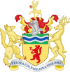
The urban district council was granted a coat of arms by the College of Arms in 1946. This featured an "enfield" (a rare heraldic beast) and a green chief with silver and blue wavy bars representing the New River, the Metropolitan Green Belt areas and open spaces. The crest was a stag representing Enfield Chase with a red rose for the Duchy of Lancaster. On incorporation as a borough, the council was eligible for a further grant of supporters, and a stag and an enfield were added on either side of the shield. [4] Much of the same symbolism was carried over to the new coat of arms of the London Borough of Enfield when the London Borough was created.

Related Research Articles

<span class="mw-page-title-main">London Borough of Enfield</span> London borough in United Kingdom

The London Borough of Enfield is a London borough in North London. It borders the London boroughs of Barnet to the west, Haringey to the south, and Waltham Forest to the southeast. To the north are the districts of Hertsmere, Welwyn Hatfield and Broxbourne, and to the east is Epping Forest District in Essex. The local authority is Enfield London Borough Council. Enfield's population is estimated to be 333,794; the main towns in the borough are Edmonton, Enfield, Southgate and Palmers Green. Enfield is the northernmost London borough.

<span class="mw-page-title-main">Enfield, London</span> Suburb of London

Enfield is a large town in north London, England, 10.1 miles (16.3 km) north of Charing Cross. It had a population of 156,858 in 2018. It includes the areas of Botany Bay, Brimsdown, Bulls Cross, Bullsmoor, Bush Hill Park, Clay Hill, Crews Hill, Enfield Highway, Enfield Lock, Enfield Town, Enfield Wash, Forty Hill, Freezywater, Gordon Hill, Grange Park, Hadley Wood, Ponders End, and World's End.

<span class="mw-page-title-main">Metropolitan Borough of Chelsea</span> Former borough of London

The Metropolitan Borough of Chelsea was a metropolitan borough of the County of London between 1900 and 1965. It was created by the London Government Act 1899 from most of the ancient parish of Chelsea. Following the London Government Act 1963, it was amalgamated with the Royal Borough of Kensington in 1965 to form the Royal Borough of Kensington and Chelsea.

<span class="mw-page-title-main">Metropolitan Borough of Hackney</span>

The Metropolitan Borough of Hackney was a metropolitan borough of the County of London from 1900 to 1965. Its area became part of the London Borough of Hackney.

<span class="mw-page-title-main">Metropolitan Borough of Stoke Newington</span> Former London borough, United Kingdom

The Metropolitan Borough of Stoke Newington was a metropolitan borough in the County of London between 1900 and 1965 when it became part of the London Borough of Hackney.

<span class="mw-page-title-main">Edmonton (UK Parliament constituency)</span> UK Parliament constituency since 1918

Edmonton is a constituency in Greater London, created in 1918 and represented in the House of Commons of the UK Parliament since 2015 by Kate Osamor, who was elected for the Labour Co-operative party but has since lost the Labour whip. Edmonton is a North London constituency based around district of Edmonton in the London Borough of Enfield.

<span class="mw-page-title-main">County Borough of East Ham</span>

East Ham was a local government district in the far south west of Essex from 1878 to 1965. It extended from Wanstead Flats in the north to the River Thames in the south and from Green Street in the west to Barking Creek in the east. It was part of the London postal district and Metropolitan Police District.

<span class="mw-page-title-main">East Barnet Urban District</span>

East Barnet Valley was a local government district from 1863 to 1965 around the town of East Barnet. It was partly in the counties of Hertfordshire and Middlesex until 1889, when the Middlesex part was transferred to Hertfordshire. It was renamed East Barnet in 1935.

<span class="mw-page-title-main">Municipal Borough of Finchley</span>

Finchley, which is now in north London, was a local government district in Middlesex, England, from 1878 to 1965. Finchley Local Board first met in 1878. It became Finchley Urban District Council in 1895 and the Municipal Borough of Finchley in 1933. In 1965 Middlesex was abolished and Finchley became part of the London Borough of Barnet.

<span class="mw-page-title-main">Municipal Borough of Bexley</span> Abolished 1965

Bexley was a local government district in north west Kent from 1879 to 1965 around the town of Old Bexley.

<span class="mw-page-title-main">Municipal Borough of Wembley</span> Former municipal borough in Middlesex, England

Wembley was an urban district and later a municipal borough in Middlesex, England from 1894 to 1965.

<span class="mw-page-title-main">Municipal Borough of Beckenham</span>

Beckenham was a local government district in north west Kent from 1878 to 1965 around the town of Beckenham. The area was suburban to London, formed part of the Metropolitan Police District and from 1933 was included in the area of the London Passenger Transport Board.

<span class="mw-page-title-main">Municipal Borough of Acton</span>

Acton was a local government district in Middlesex, England from 1865 to 1965.

<span class="mw-page-title-main">Municipal Borough of Southall</span>

Southall was a local government district in the county of Middlesex, United Kingdom from 1891 to 1965. It consisted of the civil parish of Norwood.

<span class="mw-page-title-main">Municipal Borough of Southgate</span>

Southgate was a local government district of Middlesex from 1881 to 1965. It was part of the London postal district and Metropolitan Police District.

<span class="mw-page-title-main">Municipal Borough of Twickenham</span>

Twickenham was a local government district in Middlesex, England from 1868 to 1965.

<span class="mw-page-title-main">Municipal Borough of Surbiton</span> Former local government district in Surrey, England

Surbiton was a local government district in northeast Surrey, United Kingdom, from 1855 to 1965.

<span class="mw-page-title-main">Municipal Borough of Wimbledon</span> Local government area of England

Wimbledon was a local government district in north-east Surrey from 1866 to 1965 covering the town of Wimbledon and its surrounding area. It was part of the London postal district and Metropolitan Police District.

<span class="mw-page-title-main">Chiswick Urban District</span>

Chiswick was a local government district in the county of Middlesex, England from 1858 to 1927. It was part of the London postal district and the Metropolitan Police District.

<span class="mw-page-title-main">County Borough of Stockport</span> Former municipal borough in present-day town of Stockport

Stockport County Borough was a county-level local authority between 1889 and 1974.

References

51°40′N0°05′W / 51.67°N 0.09°W / 51.67; -0.09