East Barnet Urban District

Last updated

East Barnet
East Barnet Valley (1863–1935)
District
32 Station Road, New Barnet - geograph.org.uk - 1056070.jpg
Area
  19112,644 acres (10.70 km2) [1]
  19612,644 acres (10.70 km2) [1]
Population
  191112,381 [1]
  196140,641 [1]
History
  Created1863
  Abolished1965
  Succeeded by London Borough of Barnet
Status Local government district (1863–1875)
Urban sanitary district (1875-1894)
Urban district (1894–1965)
GovernmentEast Barnet Valley Local Board (1863–1875)
East Barnet Valley Urban Sanitary Authority (1875-1894)
East Barnet Valley Urban District Council (1894–1935)
East Barnet Urban District Council (1935–1965)
   HQ Station Road, New Barnet
   Motto Willingness rids way
Coat of Arms of the East Barnet Urban District.svg
Coat of arms [2]

East Barnet Valley was a local government district from 1863 to 1965 around the town of East Barnet. It was partly in the counties of Hertfordshire and Middlesex until 1889, when the Middlesex part was transferred to Hertfordshire. It was renamed East Barnet in 1935.

Contents

Creation

The district was created under the Local Government Act 1858 on 25 September 1863, as East Barnet Valley Local Government District. [3] The district was governed by a local board. Apart from the parish of East Barnet, the local board's area included parts of the surrounding parishes of Chipping Barnet in Hertfordshire and Enfield, Monken Hadley and South Mimms in Middlesex. [4]

Reform

In 1889 Middlesex was reduced locally by the Local Government Act 1888: East Barnet Valley became entirely part of Hertfordshire.

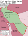
The Local Government Act 1894 reconstituted the local board's area as an urban district, governed by East Barnet Valley Urban District Council. The urban district consisted of three civil parishes, shown below with their area in 1901:

The urban district was renamed East Barnet in 1935. [5]

The district formed part of a long, thin protrusion into Middlesex and was surrounded by that county on three sides; to the north, east and south.

Coat of arms

The urban district council adopted an unofficial coat of arms consisting of a shield bearing crossed swords between a red rose of Lancaster and a white rose of York and the Greek letter omega. This design represented the Battle of Barnet, the final battle in the Wars of the Roses. The chief or top third of the shield showed a fleur de lys between two flory crosses, emblems of St Mary, the patron saint of the ancient parish of East Barnet. [6] In 1955 this became the basis for an official grant from the College of Arms. A crest was added above the shield: a hart from the arms of Hertfordshire County Council, with a shield hanging from the neck bearing the cross of St Alban for the historical associations of the Abbey of St Albans with the area. The motto adopted: Willingness Rids Way, was from Shakespeare's Henry VI, Part 3 . It comes from a speech made by Edward IV following the Battle of Barnet. [7]

Abolition

In 1965 the urban district was abolished by the London Government Act 1963 and its former area transferred from Hertfordshire to Greater London . Its former area was combined with that of other districts to form the present-day London Borough of Barnet.

Population

The area of the urban district was 2,644 acres (10.7 km2). The population, as returned at the census, was:

Year1901191119211931194119511961
Population10,09412,38113,51418,549 [8] 40,40840,641

Politics

The urban district was divided into seven wards for elections: Brunswick Park, Cockfosters, East Barnet, Hadley, Lyonsdown, New Barnet and Osidge.

Urban District council

Parliament constituency

For elections to Parliament, the urban district was part of the constituency of:

In 1945 St Albans was divided as an emergency measure because its electorate exceeded 100,000 voters, with the urban district becoming part of the new constituency of:

Related Research Articles

London Borough of Barnet Borough in United Kingdom

The London Borough of Barnet is a suburban London borough in North London. The borough was formed in 1965 from parts of the ceremonial counties of Middlesex and Hertfordshire. It forms part of Outer London and is the largest London borough by population with 384,774 inhabitants, also making it the 13th largest district in England. The borough covers an area of 86.74 square kilometres (33 sq mi), the fourth highest of the 32 London boroughs, and has a population density of 45.8 people per hectare, which ranks it 25th.

Middlesex Historic county of England

Middlesex is a historic county in southeast England. Its area is almost entirely within the wider urbanised area of London and mostly within the ceremonial county of Greater London, with small sections in neighbouring ceremonial counties. Three rivers provide most of the county's boundaries; the Thames in the south, the Lea to the east and the Colne to the west. A line of hills forms the northern boundary with Hertfordshire.

Chipping Barnet Area in the London Borough of Barnet, England

Chipping Barnet or High Barnet is a suburban market town in north London, forming part of the London Borough of Barnet, England. It is a suburban development built around a 12th-century settlement, and is located 10+12 miles (17 km) north-northwest of Charing Cross, 3 miles (4.8 km) east from Borehamwood, 5.2 miles (8.4 km) west from Enfield and 3.2 miles (5.1 km) south from Potters Bar. Its population, including its localities East Barnet, New Barnet, Hadley Wood, Monken Hadley, Cockfosters and Arkley, was 47,359 as of 2011.

New Barnet Human settlement in England

New Barnet is a neighbourhood on the north east side of the London Borough of Barnet. It is a largely residential North London suburb located east of Chipping Barnet, west of Cockfosters, south of the village of Monken Hadley and north of Oakleigh Park.

Municipal Borough of Hendon Former local authority in Middlesex, England

Hendon was an ancient civil parish of around 8,250 acres (33 km2) which included Mill Hill on the border of Hertfordshire, as well as Golders Green and Childs Hill on the border of what became the County of London. In 1894 it was created an urban district of Middlesex and in 1932 it became a municipal borough. The municipal borough was abolished in 1965 and the area became part of the London Borough of Barnet.

Osidge Human settlement in England

Osidge is a district in the London Borough of Barnet, between Brunswick Park and Southgate, just west of the border with the London Borough of Enfield. It may be loosely defined as the part of postal district N14 that is in Barnet. Osidge has no formal border and is entirely enclosed within the electoral ward of Brunswick Park, East Barnet; however Oak Hill Park forms a natural boundary to the North and Pymmes Brook to the West, with the A111 to the East and the Piccadilly line to the South/East.

Barnet Urban District

Barnet was a local government district in south Hertfordshire from 1863 to 1965 around the town of Barnet.

Municipal Borough of Finchley

Finchley, which is now in north London, was a local government district in Middlesex, England, from 1878 to 1965. Finchley Local Board first met in 1878. It became Finchley District Council in 1895 and the Municipal Borough of Finchley in 1933. In 1965 Middlesex was abolished and Finchley became part of the London Borough of Barnet.

Friern Barnet Urban District

Friern Barnet Urban District was a local government area in Middlesex, England created in 1883 from the civil parish Friern Barnet. It was succeeded by the London Borough of Barnet in 1965 as one of the smaller of its contributory predecessor districts. It was at the local level governed for nine years by the local board, then by Friern Barnet Urban District Council which operated primarily with separate functions from the County Council, operating occasionally for major planning decisions and major projects together with that body, Middlesex County Council.

Municipal Borough of Edmonton

Edmonton was a local government district in north-east Middlesex, England, from 1850 to 1965.

Potters Bar Urban District

Potters Bar Urban District was a local government district in England from 1894 to 1974, covering the town of Potters Bar and the village of South Mimms. The district was initially called the South Mimms Rural District, being renamed in 1934.

Monken Hadley Area of the London Borough of Barnet, England

Monken Hadley is a place in the London Borough of Barnet. An ancient country village north of Barnet, it is now a suburban development on the very edge of Greater London 11 miles (18 km) north north-west of Charing Cross, while retaining much of its rural character.

Elstree Rural District History of Hertfordshire

Elstree Rural District was a rural district in Hertfordshire, England from 1894 to 1974.

London Traffic Area

The London Traffic Area was established by the London Traffic Act 1924 to regulate the increasing amount of motor traffic in the London area. The LTA was abolished in 1965 on the establishment of the Greater London Council.

Hadley Wood Human settlement in England

Hadley Wood is an affluent suburb in the north of Greater London, close to the border with Hertfordshire. It appears to be a stand-alone village surrounded by Green Belt land, however, under the Local Government Act 1972 it is part of the London Borough of Enfield, about 11 miles (17.7 km) north of Charing Cross.

Enfield (UK Parliament constituency) Parliamentary constituency in the United Kingdom, 1885–1950

Enfield was a constituency for the House of Commons of the UK Parliament from 1885 until 1950. The area sloping to the River Lea in the east was in the far north of Middlesex centred on the town of Enfield. The area formed part of the London conurbation and was much reduced over the course of its existence, in 1918 and then insignificantly in 1945 due to suburbanisation and urbanisation. It returned one Member of Parliament (MP).

Edmonton Hundred

Edmonton is one of six hundreds of the historic county of Middlesex, England. A rotated L-shape, its area has been in the south and east firmly part of the urban growth of London. Since the 1965 formation of London boroughs it mainly corresponds to the London Boroughs of Enfield, a negligible portion of Barnet and a narrow majority of Haringey. Its ancient parish of South Mimms has since 1965 been part of the Hertsmere district in Hertfordshire.

Arkley Human settlement in England

Arkley is an area of north London, England, within the London Borough of Barnet. It is located 10.6 miles (17.1 km) north-northwest of Charing Cross.

Frederick Charles Cass Rector of the parish of Monken Hadley, north London

Frederick Charles Cass (1824-1896) was the rector of the parish of Monken Hadley in north London. His father, also Frederick Cass, owned the relevant advowson giving the right to make such appointments. He was the author of works of local history relating to South Mimms, Monken Hadley and East Barnet.

References

  1. 1 2 3 4 Great Britain Historical GIS / University of Portsmouth, East Barnet UD  population  (area ). Retrieved 2008-01-26.
  2. "East Barnet - Coat of arms (crest) of East Barnet". Heraldry of the World. Retrieved 9 August 2022.
  3. Kelly's Directory of Hertfordshire, 1899 , p.38 (Historical Directories)
  4. Frederic A Youngs Guide to the Local Administrative units of England, Volume I: Southern England, London 1979
  5. Great Britain Historical GIS / University of Portsmouth, East Barnet UD . Retrieved 2008-01-26.
  6. C W Scott-Giles, Civic Heraldry of England and Wales, 2nd edition, London 1953
  7. Civic Heraldry of England and Wales: Hertfordshire (obsolete), accessed January 26, 2007
  8. The census was suspended for World War II

Coordinates: 51°38′35″N0°09′40″W / 51.643°N 0.161°W / 51.643; -0.161