Kingston-upon-Thames | |
---|---|
Kingston upon Thames Guildhall | |
Area | |
• 1911 | 1,133 acres (4.6 km2) |
• 1931 | 1,131 acres (4.6 km2) |
• 1961 | 1,408 acres (5.7 km2) |
Population | |
• 1911 | 37,975 |
• 1931 | 39,055 |
• 1961 | 36,461 |
Density | |
• 1911 | 33/acre |
• 1931 | 34/acre |
• 1961 | 26/acre |
History | |
• Origin | Kingston-upon-Thames ancient borough |
• Created | 1835 |
• Abolished | 1965 |
• Succeeded by | London Borough of Kingston upon Thames |
Status | Municipal borough (1835—1965) Royal borough (confirmed 1927) Civil parish (1894—1965) |
Government | Kingston Corporation |
• HQ | Market House (1840–1935) Guildhall (1935–1965) |
Kingston-upon-Thames (spelt with hyphens) was a local government district in north east Surrey, England from 1835 to 1965 around the town now known as Kingston upon Thames. It was alternatively known as Kingston on Thames (spelt with or without hyphens). [1] [2] It was a municipal borough and also held the rarer status of Royal borough. The district was abolished in 1965 and was replaced with the larger London Borough of Kingston upon Thames in Greater London, with the Royal borough status passed to the new district.
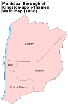
The ancient borough of Kingston-upon-Thames [2] received its charter in 1484 from Edward IV. [3] The borough corporation was reformed by the Municipal Corporations Act 1835. The ancient parish of Kingston-upon-Thames was much larger than the ancient borough. Through the gradual process of splitting off new parishes, the borough and parish became coterminous in 1894. [4]
It formed part of the expanded Metropolitan Police District from 1840 and the London Traffic Area from 1924.
It was known as a Royal borough through ancient custom and the right to the title was confirmed by George V in 1927. [3] The borough formed part of the London Passenger Transport Area from 1933.
It gained an area of 251 acres (1 km2) in the north west from the abolition of Ham Urban District in 1933 [5] and was affected by a minor exchange of territory with the Municipal Borough of Richmond in 1958. [1]
The district was abolished in 1965 by the London Government Act 1963 and its former area was transferred to Greater London to be combined with that of the Municipal Borough of Malden and Coombe and the Municipal Borough of Surbiton to form the London Borough of Kingston upon Thames; [6] with the status of Royal borough transferred to the new borough.
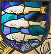
The borough's coat of arms was first registered in 1572. It was Azure three salmon naiant in pale argent. This coat of arms was re-adopted as that of the new London Borough of Kingston upon Thames in 1965, with the addition of a crest and supporters, and the changing of the colour of the fins of the three fishes from silver to red. [7]
Kingston upon Thames is a town in the Royal Borough of Kingston upon Thames, South West London, England. It is situated on the River Thames and 10 miles (16 km) southwest of Charing Cross. It is notable as the ancient market town in which Saxon kings were crowned and today is the administrative centre of the Royal Borough.
The Royal Borough of Kingston upon Thames is a borough in southwest London. The main town is Kingston upon Thames and it includes Surbiton, Chessington, Malden Rushett, New Malden and Tolworth. It is the oldest of the four royal boroughs in England. The others are Kensington and Chelsea and Greenwich also in London, and Windsor and Maidenhead. The local authority is Kingston upon Thames London Borough Council.
Norbiton is an area within the Royal Borough of Kingston upon Thames, London. It lies approximately 1 mile (1.6 km) east of Kingston upon Thames town centre, and 11 miles (17.7 km) from Charing Cross. Its main landmarks include Kingston Hospital, Kingsmeadow football stadium, Kingston Cemetery and St Peter's Anglican parish church which serves the area.
North Sheen is an area of London, England in the former Municipal Borough of Richmond (Surrey). It was incorporated into Kew in 1965 when the London Borough of Richmond upon Thames was created.
The Metropolitan Borough of Greenwich was a metropolitan borough in the County of London between 1900 and 1965. It bordered the boroughs of Woolwich, Lewisham and Deptford and, across the River Thames, the borough of Poplar and the County Borough of West Ham in Essex. Within the area of the borough were the Royal Naval College, the Royal Observatory and Greenwich Park.
Hendon was an ancient civil parish of around 8,250 acres (33 km2) which included Mill Hill on the border of Hertfordshire, as well as Golders Green and Childs Hill on the border of what became the County of London. In 1894 it was created an urban district of Middlesex and in 1932 it became a municipal borough. The municipal borough was abolished in 1965 and the area became part of the London Borough of Barnet.
Coulsdon and Purley Urban District was a local government district in northeast Surrey from 1915 to 1965. The local authority was Coulsdon and Purley Urban District Council. The former area of the district is now mostly part of the London Borough of Croydon in Greater London, with parts in the Tandridge District and the Borough of Reigate and Banstead in Surrey.
Barking was a local government district, and later civil parish and borough, in southwest Essex, England from 1882 to 1965. It was known as Barking Town from 1882 to 1931. The district included the town of Barking, eastern Beckton and the southwestern part of the Becontree estate. The district was within the Metropolitan Police District and experienced a steady increase in population during its existence. It now forms the western part of the London Borough of Barking and Dagenham and the eastern extremity of the London Borough of Newham in Greater London.
Dagenham was a local government district in south west Essex, England from 1926 to 1965 covering the parish of Dagenham. Initially created as an urban district, it was incorporated as a municipal borough in 1938. It was established to deal with the increase in population and the change from rural to urban area caused by the building of the Becontree estate by the London County Council and the subsequent movement of people from Inner London. Peripheral to London, the district formed part of the Metropolitan Police District and London Traffic Area. It now forms the eastern sections of the London Borough of Barking and Dagenham and the London Borough of Redbridge in Greater London.
Tottenham was a local government district in north east Middlesex from 1850 to 1965. It was part of the London postal district and Metropolitan Police District.
Chingford was a local government district in south west Essex, England from 1894 to 1965, around the town of Chingford. It was within the London suburbs, forming part of the London postal district and Metropolitan Police District. Its former area now corresponds to the northern part of the London Borough of Waltham Forest in Greater London.
Leyton was a local government district in southwest Essex, England, from 1873 to 1965. It included the neighbourhoods of Leyton, Leytonstone and Cann Hall. It was suburban to London, forming part of the London postal district and Metropolitan Police District. It now forms the southernmost part of the London Borough of Waltham Forest in Greater London.
Walthamstow was a local government district in southwest Essex, England from 1873 to 1965, around the town of Walthamstow. It was within the London suburbs, forming part of the London postal district and Metropolitan Police District. Its former area now corresponds to the central part of the London Borough of Waltham Forest in Greater London.
Ilford was a civil parish and local government district in south west Essex, England from 1888 to 1965, covering the town Ilford. The district saw a considerable rise in population throughout its life, caused by the expansion of the built-up area of London, and became one of the most populous districts of its type in England. The district now corresponds to the greater part of the London Borough of Redbridge in Greater London.
Surbiton was a local government district in northeast Surrey, United Kingdom from 1855 to 1965.
Malden and Coombe was a local government district in Surrey, England from 1866 to 1965.
The Municipal Borough of Richmond or Richmond Municipal Borough was a municipal borough in Surrey, England from 1890 to 1965.
Rainham is a suburb of East London, England, in the London Borough of Havering. Rainham is 13.6 miles (21.9 km) east of Charing Cross and is surrounded by a residential area, which has grown from the historic village, to the north and a commercial area, fronting the River Thames, to the south.
Canbury is a district of the northern part of Kingston upon Thames that takes its name from the historic manor that covered the area. Modern Canbury comprises two electoral wards in the constituency of Richmond Park; Canbury Ward to the south and Tudor Ward to the north.
Latchmere Recreation Ground is a public open space with playing fields and a children's playground in the north of the Royal Borough of Kingston upon Thames.