Beckton District Park North


There is access from Newham Way and Sheerwater Road, and Tollgate Road separates the park from Beckton District Park South.
A fishing lake is located in this part of the park. [1]
Beckton District Park is a public park in Beckton in the London Borough of Newham. [1] Together with King George V Park, it forms Beckton District Park and Newham City Farm, a Site of Borough Importance for Nature Conservation, Grade II. [2]
The part of the park north of the Tollgate Road is sometimes marked on maps as Beckton District Park North, and the land east of Stanfeld Road as Beckton District Park South.
The Capital Ring goes through the park and connects the North and South parts of the park via a footpath. [3] [4]
There is access from Newham Way and Sheerwater Road, and Tollgate Road separates the park from Beckton District Park South.
A fishing lake is located in this part of the park. [1]


The south-eastern part is a large grassed area with football pitches, a children's playground and a small pond. North-west is a hilly area managed for nature conservation with a wildflower meadow and woods. [5]
There is access from Stansfeld Road, Harper Road, and Tollgate Road (which separates the park from Beckton District Park North) Also from Strait Road and from the walkway from Beckton DLR station.
New Beckton Park is a neighbouring small park. It has a grassed area with sports pitches, a running track and outdoor exercise equipment. There is access from Savage Gardens. [6]
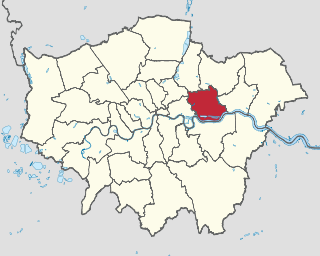
The London Borough of Newham is a London borough created in 1965 by the London Government Act 1963. It covers an area previously administered by the Essex county boroughs of West Ham and East Ham, authorities that were both abolished by the same act. The name Newham reflects its creation and combines the compass points of the old borough names. Situated in the Inner London part of East London, Newham has a population of 387,576, which is the fourth highest of the London boroughs and also makes it the 26th most populous district in England. The local authority is Newham London Borough Council.
Plaistow is a suburban area of East London, England, within the London Borough of Newham. It adjoins Upton Park to the north, East Ham to the east, Beckton to the south, Canning Town to the south-west and West Ham to the west.

East Ham is a district of the London Borough of Newham, England, 8 miles (12.8 km) east of Charing Cross. Within the boundaries of the historic county of Essex, East Ham is identified in the London Plan as a Major Centre. The population is 76,186.

Manor Park is a residential area of the London Borough of Newham in east London, England. The area is bordered by Ilford to the east, Forest Gate to the west, Wanstead to the north, and East Ham to the south.

Canning Town is a district in the London Borough of Newham, East London, England, north of the Royal Victoria Dock. Its urbanisation was largely due to the creation of the dock. The area was part of the ancient parish of West Ham, in the hundred of Becontree, and the historic county of Essex. It forms part of the London E16 postcode district.

Royal Docks is an area and a ward in the London Borough of Newham in the London Docklands in East London, England.

The Thames Gateway Bridge was a proposed crossing over the River Thames in east London, England. It was first mooted in the 1970s but never came to fruition. The concept was re-proposed in 2004, with preliminary planning proceeding until November 2008, when Boris Johnson, the then Mayor of London, formally cancelled the entire £500 million scheme.

Beckton is a suburb in east London, England, located 8 miles (12.9 km) east of Charing Cross and part of the London Borough of Newham. Adjacent to the River Thames, the area consisted of unpopulated marshland known as the East Ham Levels in the parishes of Barking, East Ham, West Ham and Woolwich. The development of major industrial infrastructure in the 19th century to support the growing metropolis of London caused an increase in population with housing built in the area for workers of the Beckton Gas Works and Beckton Sewage Treatment Works. The area has a convoluted local government history and has formed part of Greater London since 1965. Between 1981 and 1995 it was within the London Docklands Development Corporation area, which caused the population to increase as new homes were built and the Docklands Light Railway was constructed.

The Greenway is a 7-kilometre (4.3 mi) long footpath and cycleway in London, mostly in the London Borough of Newham, on the embankment containing the Joseph Bazalgette Northern Outfall Sewer.

East Ham is a constituency in the London Borough of Newham represented in the House of Commons of the UK Parliament since its creation in 1997 by Stephen Timms of the Labour Party.

The London Riverside is a redevelopment area on the north side of the River Thames in East London, England. The area was identified as a zone of change following the introduction of the Thames Gateway policy in 1995. Proposals for improvements in the area were at first developed by Havering and Barking and Dagenham councils, with a London Riverside Urban Strategy published in 2002. This was incorporated into the first London Plan published by the Mayor of London in 2004. Between 2004 and 2013 the planning powers in London Riverside and the Lower Lea Valley were the responsibility of the London Thames Gateway Development Corporation. Planning powers have now reverted to the local councils. Much of the land available for redevelopment is now owned by GLA Land and Property. There is also a London Riverside business improvement district, which covers a smaller area.
East Ham was a local government district in the far south west of Essex from 1878 to 1965. It extended from Wanstead Flats in the north to the River Thames in the south and from Green Street in the west to Barking Creek in the east. It was part of the London postal district and Metropolitan Police District.

The London Borough of Newham, in spite of being one of the more crowded areas of London, has over 20 parks within its boundaries, as well as smaller recreation grounds. The larger parks in the Borough include:

Old Court House Recreation Ground is a public park in High Barnet in the London Borough of Barnet. It is one of the borough's Premier Parks and received a Green Flag Award for 2009–2010.

Victoria Recreation Ground is a public park in New Barnet in the London Borough of Barnet, United Kingdom. It is one of Barnet's 'Premier Parks'.

Brent Park is a small public park of 2.24 hectares in Hendon in the London Borough of Barnet. It is part of the 'Lower Dollis Brook' Site of Borough Importance for Nature Conservation, Grade II.

The 2014 Newham London Borough Council election took place on 22 May 2014 to elect members of Newham London Borough Council in England. This was on the same day as other local elections.
The Docklands Light Railway extension to Thamesmead is a proposed Docklands Light Railway (DLR) extension to serve the Beckton Riverside and Thamesmead redevelopment areas of East London.
| Districts |
|   |
|---|---|---|
| Attractions | ||
| Sports | ||
| Shopping centres and markets | ||
| Parks and open spaces | ||
| Constituencies | ||
| Tube, railway and DLR stations |
| |
| Other topics | ||