The Docklands Light Railway (DLR) is an automated light metro system primarily serving the redeveloped Docklands area of London and providing a direct connection between London's two major financial districts, Canary Wharf and the City of London. First opened on 31 August 1987, the DLR has been extended multiple times, giving a total route length of 38 km. Lines now reach north to Stratford, south to Lewisham, west to Tower Gateway and Bank in the City of London financial district, and east to Beckton, London City Airport and Woolwich Arsenal. Further extensions are being considered.
London Docklands is the riverfront and former docks in London. It is located in inner east and southeast London, in the boroughs of Southwark, Tower Hamlets, Lewisham, Newham, and Greenwich. The docks were formerly part of the Port of London, at one time the world's largest port. After the docks closed, the area had become derelict and poverty-ridden by the 1980s. The Docklands' regeneration began later that decade; it has been redeveloped principally for commercial and residential use. The name "London Docklands" was used for the first time in a government report on redevelopment plans in 1971 and has since been almost universally adopted. The redevelopment created wealth, but also led to some conflict between the new and old communities in the area.
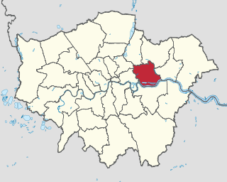
The London Borough of Newham is a London borough created in 1965 by the London Government Act 1963. It covers an area previously administered by the Essex county boroughs of West Ham and East Ham, authorities that were both abolished by the same act. The name Newham reflects its creation and combines the compass points of the old borough names. Situated in the Inner London part of East London, Newham has a population of 387,576, which is the third highest of the London boroughs and also makes it the 16th most populous district in England. The local authority is Newham London Borough Council.

Custom House is a railway station on the Docklands Light Railway (DLR) – on which it is branded Custom House for ExCeL – and on the Elizabeth line, by the Royal Docks, in Custom House in the London Borough of Newham, London, England. It is situated in Travelcard Zone 3. It takes its name from the old Custom House, which formerly stood nearby, and ExCeL London which it serves.

Royal Docks is an area and a ward in the London Borough of Newham in the London Docklands in East London, England.

The Royal Victoria Dock is the largest of three docks in the Royal Docks of east London, now part of the redeveloped Docklands.

University of East London (UEL) is a public university located in the London Borough of Newham, London, England, based at three campuses in Stratford and Docklands, following the opening of University Square Stratford in September 2013. The University of East London began as the West Ham Technical Institute and it was officially opened in October 1898 after approval was given for the construction of the site by the West Ham Technical Instruction Act Committee in 1892 following the Technical Instruction Act of 1889. It gained university status in 1992. It was formerly known as College of East London.

Royal Albert DLR station is a station on the Docklands Light Railway (DLR) in Beckton in east London. The station serves the western end of the north quay of the Royal Albert Dock, from which it takes its name. A view of the London City Airport is available.

Prince Regent DLR station is a station on the Docklands Light Railway (DLR) in Canning Town in east London. The station was opened on 28 March 1994 and provides access to the eastern end of the ExCeL Exhibition Centre and ICC London. The station signage is subtitled 'for ExCeL East'.

Beckton is a suburb in east London, England, located 8 miles (12.9 km) east of Charing Cross and part of the London Borough of Newham. Adjacent to the River Thames, the area consisted of unpopulated marshland known as the East Ham Levels in the parishes of Barking, East Ham, West Ham and Woolwich. The development of major industrial infrastructure in the 19th century to support the growing metropolis of London caused an increase in population with housing built in the area for workers of the Beckton Gas Works and Beckton Sewage Treatment Works. The area has a convoluted local government history and has formed part of Greater London since 1965. Between 1981 and 1995 it was within the London Docklands Development Corporation area, which caused the population to increase as new homes were built and the Docklands Light Railway was constructed.
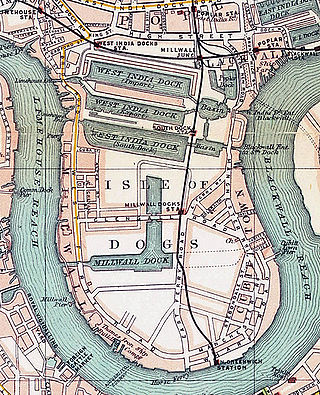
Millwall Dock is a dock at Millwall, London, England, located south of Canary Wharf on the Isle of Dogs.

Beckton Park DLR station is a station on the Docklands Light Railway (DLR) in the Docklands area of east London. The station is located by the north quay of the Royal Albert Dock. The station is opposite Beckton District South Park, which is open space leading to housing in South Beckton.

Cyprus is a station on the Docklands Light Railway (DLR) located in Cyprus, to the south of Beckton, in the Docklands area of Newham, east London. The area is named after the Mediterranean island of Cyprus. The station serves the University of East London Docklands Campus and the eastern end of the north quay of the Royal Albert Dock.

Gallions Reach DLR station is a station on the Docklands Light Railway (DLR) in the Royal Docks area of east London. It serves the recent residential developments around Royal Albert Dock. The station is located on the DLR's Beckton branch, between Cyprus and Beckton stations. It is in Travelcard Zone 3.

The University of East London Docklands Campus is a campus of the University of East London (UEL) situated in the Docklands area of east London. The campus opened in 1999. It is one of two campuses in UEL, the other being the Stratford Campus.

Custom House is an area in the London Borough of Newham, in East London, England.
Central was a railway station near the Royal Albert Dock and Beckton Park, in east London. It was served by the London & St. Katharine Docks Company and was located between Connaught Road and Manor Way stations, on the Gallions branch of the line.

Manor Way was a railway station on East Ham Manor Way, south of Beckton in east London, on the London & St. Katharine Docks Company's line. It opened in November 1880 between Central and Gallions stations on the Gallions branch of the line, and was re-sited to the east side of the Manor Way in 1887.