
Bow Creek Ecology Park is a small open space along Bow Creek tidal estuary of the River Lea in Canning Town in Newham, in east London. It is operated by the regional Lee Valley Park system.
Bow Creek Ecology Park is a small open space along Bow Creek tidal estuary of the River Lea in Canning Town in Newham, in east London. It is operated by the regional Lee Valley Park system.
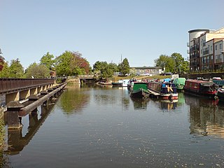
Bow Creek Ecology Park is a small park running alongside and underneath the Docklands Light Railway near Canning Town Station. [1] The Bow Creek reach of the lower River Lea is a tidal estuary here in Lower Lea Valley.
The park features small streams and ponds, an outdoor classroom, footpaths, observation points, and seating. It is an important resource for local education. [2]
The park was created by the London Docklands Development Corporation (LDDC) in 1994, after a survey identified rare and unusual plant species in the area, some presumed carried in by shipping, such as Hairy Buttercup (Ranunculus sardous), Walthamstow Cress, and Unreel's Wormwood. [3]
The park was officially opened in 1996 by Eastenders actress Michelle Collins for BBC Education programme "Science Zone". [4]
The Park has won a Green Flag Award for the fourth year in 2010, [5] and was also nominated for the UK Landscape Award 2010. [6]
The River Lea is in South East England. It originates in Bedfordshire, in the Chiltern Hills, and flows southeast through Hertfordshire, along the Essex border and into Greater London, to meet the River Thames at Bow Creek. It is one of the largest rivers in London and the easternmost major tributary of the Thames.
The Hertford Union Canal or Duckett's Cut is just over 1 mile (1.6 km) long in the London Borough of Tower Hamlets in East London. It connects the Regent's Canal to the Lee Navigation. It was opened in 1830 but quickly proved to be a commercial failure. It was acquired by the Regents Canal Company in 1857, and became part of the Grand Union Canal in 1927.

The Lee Navigation is a canalised river incorporating the River Lea. It flows from Hertford Castle Weir to the River Thames at Bow Creek; its first lock is Hertford Lock and its last Bow Locks.

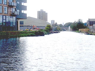
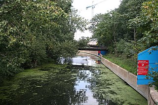
Bow Creek is a 2.25-mile (3.6 km) long tidal estuary of the English River Lea and is part of the Bow Back Rivers. Below Bow Locks the creek forms the boundary between the London Boroughs of Newham and Tower Hamlets, in East London.
Bow Back Rivers or Stratford Back Rivers is a complex of waterways between Bow and Stratford in east London, England, which connect the River Lea to the River Thames. Starting in the twelfth century, works were carried out to drain Stratford Marshes and several of the waterways were constructed to power watermills. Bow Creek provided the final outfall to the Thames, and the other channels were called Abbey Creek, Channelsea River, City Mill River, Prescott Channel, Pudding Mill River, Saint Thomas Creek, Three Mills Back River, Three Mills Wall River and Waterworks River.

The Lower Lea Valley is the southern end of the Lea Valley which surrounds the River Lea. It is part of the Thames Gateway redevelopment area and was the location of the 2012 Summer Olympics.

London is the largest urban area and capital city of the United Kingdom. It is located in the southeast of Great Britain. The London region covers an area of 1,579 square kilometres (610 sq mi), and had a population of 7,172,036 in 2001 and a population density of 4,542 people per square kilometre. A larger area, referred to as the London Metropolitan Region or the London Metropolitan Agglomeration covers an area of 8,382 square kilometres (3,236 sq mi), and had a population of 12,653,500 and a population density of 1,510 people per square kilometre.
Lee Valley Regional Park is a 10,000-acre (40 km2) 26 miles (42 km) long linear park, much of it green spaces, running through the northeast of Greater London, Essex and Hertfordshire from the River Thames to Ware, through areas such as Stratford, Clapton, Tottenham, Enfield, Walthamstow, Cheshunt, Broxbourne and Hoddesdon in an area generally known as the Lea Valley. Greater London's largest park, Lee Valley Park is more than four times the size of Richmond Park, extending beyond Greater London's borders into the neighbouring counties of Hertfordshire and Essex.

The London Borough of Tower Hamlets, in spite of being close to the centre of London and perhaps retaining the idea of it being the docklands area, has over 100 areas of parks and open spaces within its boundaries. These range from the huge to small gardens and squares. In common with all the London boroughs, these green spaces provide "lungs" for the leisure pursuits of the inhabitants.

The London Borough of Newham, in spite of being one of the more crowded areas of London, has over 20 parks within its boundaries, as well as smaller recreation grounds. The larger parks in the Borough include:
The Tideway is that part of the River Thames in England which is subject to tides. This stretch of water is downstream from Teddington Lock. The Tideway comprises the upper Thames Estuary including the Pool of London.
The Lea Valley, the valley of the River Lea, has been used as a transport corridor, a source of sand and gravel, an industrial area, a water supply for London, and a recreational area. The London 2012 Summer Olympics were based in Stratford, in the Lower Lea Valley. It is very important for London's water supply, as the source of the water transported by the New River aqueduct, but also as the location for the Lee Valley Reservoir Chain, stretching from Enfield through Tottenham and Walthamstow.

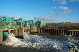
The Prescott Channel was built in 1930–35 as part of a flood relief scheme for the River Lee Navigation in the East End of London, England, and was named after Sir William Prescott, the then chairman of the Lee Conservancy Board. Rubble from the demolished Euston Arch was used in 1962 to improve the channel, which forms part of the Bow Back Rivers.

The Lea Valley Walk is a 50-mile (80 km) long-distance path located between Leagrave, the source of the River Lea near Luton, and the Thames, at Limehouse Basin, Limehouse, east London. From its source much of the walk is rural. At Hertford the path follows the towpath of the River Lee Navigation, and it becomes increasingly urbanised as it approaches London. The walk was opened in 1993 and is waymarked throughout using a swan logo.
The Lee Flood Relief Channel (FRC) is located in the Lea Valley and flows between Ware, Hertfordshire, and Stratford, east London. Work started on the channel in 1947 following major flooding and it was fully operational by 1976. The channel incorporates existing watercourses, lakes, and new channels. Water from the channel feeds the Lee Valley Reservoir Chain.

Old Ford Lock is a paired lock and weir on the River Lee Navigation, in the London Borough of Tower Hamlets, England. It is at Fish Island in Old Ford and takes its name from the natural ford which used to cross the River Lea.

Waterworks River is a river, at one time a tidal river, in the London Borough of Newham, one of the Bow Back Rivers that flow into the Bow Creek part of the River Lea, which in turn flows into the River Thames.
The Old River Lea is the former natural channel of the River Lea below Lea Bridge, in the London Borough of Hackney. The Old River forms a large meander from the Middlesex Filter Beds Weir to rejoin the main channel of the River Lee Navigation below Old Ford Lock, just west of the 2012 Olympic stadium.

Springfield Park is a park in Upper Clapton in the London Borough of Hackney.
Coordinates: 51°30′44″N0°00′12″E / 51.5121°N 0.0034°E
| | This London location article is a stub. You can help Wikipedia by expanding it. |