Lee Flood Relief Channel

Last updated

Newmans Sluices on the River Lee Flood Relief Channel, pictured on a day of strong water flow River Lee Flood Relief Channel, Newmans Sluices - geograph.org.uk - 73758.jpg
Newmans Sluices on the River Lee Flood Relief Channel, pictured on a day of strong water flow

The Lee Flood Relief Channel (FRC) is located in the Lea Valley and flows between Ware, Hertfordshire, and Stratford, east London. Work started on the channel in 1947 following major flooding and it was fully operational by 1976. The channel incorporates existing watercourses, lakes, and new channels. [1] Water from the channel feeds the Lee Valley Reservoir Chain. [2]

Contents

Design

Flood defences are rated according to the probability that a particular level of flood water will be exceeded at least once in a specific period, so a 100-year flood represents a level that would only be expected to occur once in 100 years. This is often known as 1 per cent protection. The level of flooding in 1947 was estimated to be a 1.4 per cent occurrence, and the flood channel, when it was first designed, was built to cope with this level of flooding. Since it was completed in 1976, there have been no major flood events in the Lea Valley, although there have been three occasions when the river system was full virtually to its capacity: in 1987, 1993 and 2000. Since its completion, the level of protection afforded by the structure has declined, so that in some areas it offers 2 per cent protection, and in some, only 5 per cent protection. The Environment Agency published a strategic environmental assessment in 2008, which looked at ways to maintain the flood defences in the Lea Valley. [3]

Course

Hertfordshire and Essex

Flood Relief Channel at Feildes Weir FeildesWeir3.jpg
Flood Relief Channel at Feildes Weir
The channel at the Central lagoon, Nazeing Mead, Nazeing River Lee Flood Relief Channel2.JPG
The channel at the Central lagoon, Nazeing Mead, Nazeing
The channel below the B194 road bridge at Nazeing River Lee Flood Relief Channel1.JPG
The channel below the B194 road bridge at Nazeing

Marking the start of the FRC at Ware, the channel is incorporated into the Lee Navigation. It flows through Hardmead Lock and Stanstead Lock, which have had automatic sluice gates installed to cope with high water levels. At Feildes Weir a parallel channel has been constructed. The channel then skirts the 120-acre (49 ha) Glen Faba Lake and passes under Dobbs Weir Road before entering the North Lagoon of the Nazeing Meads lake complex and leaving at the South Lagoon at Nazeing Weir. Continuing under Nazeing Road (B194), the channel flows through the River Lee Country Park at Holyfield Lake and out through Holyfield Weir. Flowing under Stubbins Hall Lane, it merges with the old River Lea at Fishers Green. After skirting Seventy Acres Lake and then Hooks Marsh Lake, the channel is incorporated into the Horsemill Stream, also known as Waltons Walk. The water forms a natural boundary for the Royal Gunpowder Mills as it passes through the mechanically controlled radial gates of the David Stoker sluice near Waltham Abbey. Now flowing parallel with the Lee Navigation, and only yards apart, the channel flows firstly under the A121 road and through Rammey Marsh Sluice - a set of three computer-controlled vertical lift sluice gates and then under the M25 motorway to be joined by Cobbins Brook before flowing through Newman's Sluice – a set of four computer-controlled vertical lift sluice gates.

Greater London

The confluence of the River Lee Flood Relief Channel in foreground with the River Lea to become the River Lee Diversion below Enfield Island Village before flowing around the eastern perimeter of the King George V Reservoir River Lee Flood Relief Channel.jpg
The confluence of the River Lee Flood Relief Channel in foreground with the River Lea to become the River Lee Diversion below Enfield Island Village before flowing around the eastern perimeter of the King George V Reservoir

The channel crosses Rammey Marsh to form the eastern boundary of the former Royal Small Arms Factory, which is now a housing development called Enfield Island Village. Further downstream, the channel merges with the River Lea to become the man-made, concrete-banked River Lee Diversion as it skirts the eastern perimeter of the King George V Reservoir, the first of the Lee Valley Reservoir Chain, and then the William Girling Reservoir. The river forms the boundary of the London Borough of Enfield and Waltham Forest and the historical boundary between Middlesex and Essex. Flowing under the North Circular Road and close to Banbury Reservoir, it splits from the River Lee Diversion to cross Tottenham Marshes, and passes close to the Lockwood Reservoir, High Maynard Reservoir and Low Maynard Reservoir. Flowing firstly under Forest Road (A503 road) and then the Gospel Oak to Barking line, it skirts the Walthamstow Reservoirs close to Walthamstow Marshes. It passes under Coppermill Lane before flowing under the Lea Valley Line as the channel approaches Lea Bridge Road, part of the A104 road. It crosses Hackney Marshes and passes through a culvert before joining the Old River Lea close to the New Spitalfields Market. Passing under the Eastway road and then flowing under the A115 (Carpenter's Road) to meet the Waterworks River below Carpenter's Road Lock in Stratford, the channel continues through the Prescott Channel and Bow Creek to reach the Thames at Leamouth.

Related Research Articles

River Lea River in southern England

The River Lea is a river in South East England. It originates in the Chiltern Hills, England, and flows southeast through east London where it meets the River Thames, the last looping section being known as Bow Creek. It is one of the largest rivers in London and the easternmost major tributary of the Thames. Its valley creates a long chain of marshy ground along its lower length, much of which has been used for gravel and mineral extraction, reservoirs and industry. Much of the river has been canalised to provide a navigable route for boats into eastern Hertfordshire, known as the Lee Navigation. While the lower Lea remains somewhat polluted, its upper stretch and tributaries, classified as chalk streams, are a major source of drinking water for London. A diversion known as the New River, opened in 1613, abstracts clean water away from the lower stretch of the river for drinking. Its origins in the Chilterns contribute to the extreme hardness of London tap water.

River Tame, West Midlands main river of the West Midlands of England

The River Tame is the main river of the West Midlands of England, and one of the principal tributaries of the River Trent. The Tame is about 95 km (59 mi) long from the source at Oldbury to its confluence with the Trent near Alrewas, but the main river length of the entire catchment, i.e. the Tame and its main tributaries, is about 285 km (177 mi).

River Rother, South Yorkshire river in South Yorkshire, UK

The River Rother, a waterway in the northern midlands of England, gives its name to the town of Rotherham and to the Rother Valley parliamentary constituency. It rises near Clay Cross in Derbyshire and flows in a generally northwards direction through the centre of Chesterfield, where it feeds the Chesterfield Canal, and on through the Rother Valley Country Park and several districts of Sheffield before joining the River Don at Rotherham in Yorkshire.

Bow Back Rivers

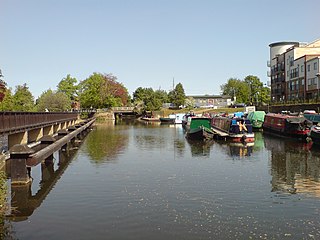
Bow Back Rivers or Stratford Back Rivers is a complex of waterways between Bow and Stratford in east London, England, which connect the River Lea to the River Thames. Starting in the twelfth century, works were carried out to drain Stratford Marshes and several of the waterways were constructed to power watermills. Bow Creek provided the final outfall to the Thames, and the other channels were called Abbey Creek, Channelsea River, City Mill River, Prescott Channel, Pudding Mill River, Saint Thomas Creek, Three Mills Back River, Three Mills Wall River and Waterworks River.

Lee Valley Park park in the Lee Valley

Lee Valley Regional Park is a 10,000-acre (40 km2) 26 miles (42 km) long linear park, much of it green spaces, running through the northeast of Greater London, Essex and Hertfordshire from the River Thames to Ware, through areas such as Stratford, Clapton, Tottenham, Enfield, Walthamstow, Cheshunt, Broxbourne and Hoddesdon in an area generally known as the Lea Valley. Greater London's largest park, Lee Valley Park is more than four times the size of Richmond Park, extending beyond Greater London's borders into the neighbouring counties of Hertfordshire and Essex.

Locks and Weirs on the River Lea

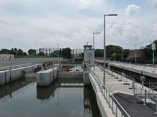
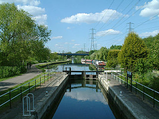
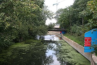
This article contains a complete list of locks and weirs on the River Lea/River Lee Navigation.

Hertford Castle Weir

Hertford Castle Weir is a weir located in Hertford near to Hertford Castle and next to Hertford Theatre.

Lea Valley Walk

The Lea Valley Walk is a 50-mile (80 km) long-distance path located between Leagrave, the source of the River Lea near Luton, and the Thames, at Limehouse Basin, Limehouse, east London. From its source much of the walk is rural. At Hertford the path follows the towpath of the River Lee Navigation, and it becomes increasingly urbanised as it approaches London. The walk was opened in 1993 and is waymarked throughout using a swan logo.

Small River Lea river in the United Kingdom

The Small River Lea is a minor tributary of the River Lea, which flows through the Lee Valley Park between Cheshunt and Enfield Lock. It forms part of the Turnford and Cheshunt Pits Site of Special Scientific Interest (SSSI) as it flows through the River Lee Country Park.

Feildes Weir

Feildes Weir is a weir on the River Lea located near Hoddesdon, Hertfordshire at the confluence of the River Lea and River Stort. The weir marks the start of the Lower Lee. A channel of the man-made River Lee Flood Relief Channel is incorporated into the weir.

River Lee Diversion

The River Lee Diversion is located in the Lea Valley, close to Enfield Lock and to the north east corner of the King George V Reservoir.

Dagenham Brook

Dagenham Brook is a minor tributary of the River Lea. It is located in the London Borough of Waltham Forest and is the traditional eastern limit of Leyton Marshes.

Rammey Marsh Lock

Rammey Marsh Lock is a lock on the River Lee Navigation at Enfield, London, England. The area adjacent to the lock is known as Rammey Marsh and close to the River Lee Flood Relief Channel.

River Lee Country Park

The River Lee Country Park is located in the Lee Valley Park and is managed by the Lee Valley Regional Park Authority. Covering 1,000 acres (400 ha) acres on either side of the River Lee Navigation between Waltham Abbey and Broxbourne. An area of lakes, watercourses, open spaces and three Sites of Special Scientific Interest (SSSI) linked by footpaths and cycle tracks.

Aqueduct Lock

Aqueduct Lock (No8) is a lock on the River Lee Navigation close to Turnford.

Carthagena Lock

Carthagena Lock (No7) is a lock on the River Lee Navigation at Broxbourne

Dobbs Weir Lock

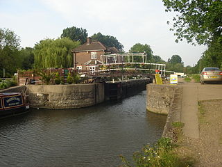
Dobbs Weir Lock is a lock on the River Lee Navigation near Hoddesdon.

Old River Lea river in the United Kingdom

The Old River Lea is the former natural channel of the River Lea below Lea Bridge, in the London Borough of Hackney. The Old River forms a large meander from the Middlesex Filter Beds Weir to rejoin the main channel of the River Lee Navigation below Old Ford Lock, just west of the 2012 Olympic stadium.

Cornmill Stream river in the United Kingdom

The Cornmill Stream is a minor tributary of the River Lea in the English county of Essex.

Rammey Marsh

Rammey Marsh is located in the Lee Valley Park at Enfield Lock, Enfield, London and covers approximately 42 hectares. The site is owned and managed by the Lee Valley Regional Park Authority.

References

  1. "Managing flood risk in the Lower Lee catchment, today and in the future" (PDF). Environment Agency. Retrieved 23 May 2017.
  2. "ALGAE IN RAW WATER STORAGE RESERVOIRS: A CASE STUDY INTO THE EFFECT ON RAPID GRAVITY FILTRATION" (PDF). Archived from the original (PDF) on 24 January 2011. Retrieved 23 May 2017.
  3. "Lower Lee Flood Risk Management Strategy" (PDF). Environment Agency. Archived from the original (PDF) on 28 September 2013. Retrieved 23 May 2017.

Coordinates: 51°41′52″N0°00′48″W / 51.6979°N 0.0134°W / 51.6979; -0.0134