
Rammey Marsh is located in the Lee Valley Park at Enfield Lock, Enfield, and covers approximately 42 hectares (100 acres). The site is owned and managed by the Lee Valley Regional Park Authority. [1]
Rammey Marsh is located in the Lee Valley Park at Enfield Lock, Enfield, and covers approximately 42 hectares (100 acres). The site is owned and managed by the Lee Valley Regional Park Authority. [1]
The site is bounded by the M25 to the north. Mollison Avenue A1055 forms the majority of the western boundary together with a short section of the Lee Valley railway line, its eastern boundary is formed by the Lee Navigation while Smeaton Road forms the southern boundary. Flowing under the M25 the Small River Lea enters the site for a short distance before flowing under the A1055 road.

Rammey Marsh is marked thus on the Ordnance Survey map of 1887, named from Ramhey 1538, Rammey 1610, probably 'island (of dry ground in marsh) where rams are pastured', from Old English ramm and ēg. [2]
Rammey Marsh was once part of an extensive floodplain which stretched down to the River Thames. The marsh was used as pasture for summer grazing since Anglo-Saxon times. During the mid 20th century much of the marsh was given over to gravel extraction. The resulting flooded gravel pits were used for landfill which raised the profile of the site.
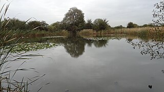
On completion of the A1055 road in the late 20th century, the marsh was bisected from north to south. To the west of the road which approximately follows the course of the Small River Lea was the site of the former Rammey Marsh Sewage Treatment Works. Today, the site is the home to the Innova Business and Science Park, Oasis Academy School, hotel, housing and Rammey Marsh lake a former gravel pit 51°40′22″N0°01′13″W / 51.6729°N 0.0202°W [3] which has matured into a conservation area and fishery. [4]
A dry ditch which was a channel of the Small River Lea splits the site into two distinct areas, with the south being mixed grassland which is mostly flat and bisected by several maintained grass paths and the north resembling an undulating chalk grassland. [5]
Some 225 plant species are present on the site, including pyramidal orchid and a colony of over 5000 bee orchid believed to be the largest group of this type in South East England. Birds such as reed bunting, skylark, meadow pipit, linnet have been recorded and the marsh is also an important site for spring visitors. Grassland provides a good habitat for the grass snake. Mammals seen on the marsh include pipistrelle bats. The Small River Lea provides an important habitat for the water vole [1]
Attempts to construct two ponds were unsuccessful due to ground contamination. Additional projects include the building of amphibian and reptile refuges using soil and rubble and plans to re-work the banks of the central ditch to improve the habitat for water voles and other animals during the winter of 2010/11. [1]
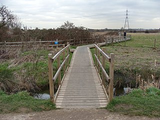
Car parking is available at Smeaton Road. Pedestrian and cycle access is found at various points around the site. The towpath of the Lee Navigation forms part of the Lee Valley Walk lies on the marsh's eastern fringe.
The River Lea is in South East England. It originates in Bedfordshire, in the Chiltern Hills, and flows southeast through Hertfordshire, along the Essex border and into Greater London, to meet the River Thames at Bow Creek. It is one of the largest rivers in London and the easternmost major tributary of the Thames.

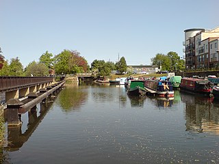
The Lee Navigation is a canalised river incorporating the River Lea. It flows from Hertford Castle Weir to the River Thames at Bow Creek; its first lock is Hertford Lock and its last Bow Locks.

Bow Creek is a 2.25-mile (3.6 km) long tidal estuary of the English River Lea and is part of the Bow Back Rivers. Below Bow Locks the creek forms the boundary between the London Boroughs of Newham and Tower Hamlets, in East London.
Enfield Lock is an area in the London Borough of Enfield, north London. It is approximately located east of the Hertford Road between Turkey Street and the Holmesdale Tunnel overpass, and extends to the River Lee Navigation, including the Enfield Island Village. The locality gains its name from the lock on the River Lee Navigation. Today's Enfield Lock was rebuilt in 1922. The area forms part of the Lee Valley Park and the Enfield Lock Conservation Area. On its eastern boundary Enfield Lock has marshland formerly used as a testing site between the Royal Small Arms Factory and the Gunpowder Mills, beyond this is the village of Sewardstone and the Epping forest boundary. To the south is Brimsdown, the north Waltham Cross and to the west Bullsmoor and Freezywater. Enfield Lock forms part of the London boundary.

Ingrebourne Valley is a local nature reserve (LNR) in Hornchurch in the London Borough of Havering. It is owned and managed by Havering Council, and has a visitor centre managed by the Essex Wildlife Trust. Most of it is in Hornchurch Country Park west of the River Ingrebourne, but there are also areas north and south of the park which are part of the LNR. It has a wide range of habitats, including woodland, grassland, the river and marshes. It is an important site for a range of species of plants, animals and birds, including great crested newts, slow worms, the harvest mouse and the water vole.
Walthamstow Marshes, is a 36.7 hectare biological Site of Special Scientific Interest in Walthamstow in the London Borough of Waltham Forest. It was once an area of lammas land – common land used for growing crops and grazing cattle.
The Lea Valley, the valley of the River Lea, has been used as a transport corridor, a source of sand and gravel, an industrial area, a water supply for London, and a recreational area. The London 2012 Summer Olympics were based in Stratford, in the Lower Lea Valley. It is important for London's water supply, as the source of the water transported by the New River aqueduct, but also as the location for the Lee Valley Reservoir Chain, stretching from Enfield through Tottenham and Walthamstow.

This article contains a complete list of locks and weirs on the River Lea/River Lee Navigation from Hertford downstream.
Pickett's Lock or Picketts Lock is an area of Edmonton, in the London Borough of Enfield. It is bordered by River Lee Navigation to the east, Pickett's Lock Lane to the south, Meridian Way A1055 to the west and the Ponders End industrial area to the north. The area takes its name from Pickett's Lock, a lock on the nearby River Lee Navigation.

The Lea Valley Walk is a 50-mile (80 km) long-distance path located between Leagrave, the source of the River Lea near Luton, and the Thames, at Limehouse Basin, Limehouse, east London. From its source much of the walk is rural. At Hertford the path follows the towpath of the River Lee Navigation, and it becomes increasingly urbanised as it approaches London. The walk was opened in 1993 and is waymarked throughout using a swan logo.

The Small River Lea is a minor tributary of the River Lea, which flows through the Lee Valley Park between Cheshunt and Enfield Lock. It forms part of the Turnford and Cheshunt Pits Site of Special Scientific Interest (SSSI) as it flows through the River Lee Country Park.
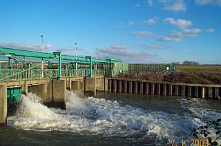
The Lee Flood Relief Channel (FRC) is located in the Lea Valley and flows between Ware, Hertfordshire, and Stratford, east London. Work started on the channel in 1947 following major flooding and it was fully operational by 1976. The channel incorporates existing watercourses, lakes, and new channels. Water from the channel feeds the Lee Valley Reservoir Chain.

The River Lee Diversion is located in the Lea Valley, close to Enfield Lock and to the north east corner of the King George V Reservoir.

The Tottenham Marshes are located at Tottenham in the London Borough of Haringey. The marshes cover over 100 acres (0.40 km2) and became part of the Lee Valley Park in 1972. The marsh is made up of three main areas: Clendish Marsh, Wild Marsh West and Wild Marsh East. The latter two are separated by the River Lea.

Leyton Marsh is an open space in the Lower Lea Valley, located in Leyton in the London Borough of Waltham Forest.

Pickett's Lock is a lock on the River Lee Navigation in the London Borough of Enfield, England and is located near Edmonton, London. It gives its name to the surrounding area of Picketts Lock. In common with other locks as far upstream as Ponder's End Lock it is large enough to take barges of up to 130 tons. However it has not been upgraded to power operation and so it must be manually operated. It has gate paddles but these do not have gate baffles to mitigate the rush of water into the lock.
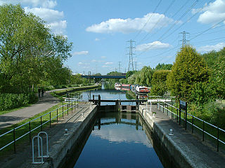
Rammey Marsh Lock is a lock on the River Lee Navigation at Enfield, London, England. The area adjacent to the lock is known as Rammey Marsh and close to the River Lee Flood Relief Channel.

The River Lee Country Park is located in the Lee Valley Park and is managed by the Lee Valley Regional Park Authority. Covering 1,000 acres (400 ha) on either side of the River Lee Navigation between Waltham Abbey and Broxbourne, it is an area of lakes, watercourses, open spaces and three Sites of Special Scientific Interest (SSSI) linked by footpaths and cycle tracks.
The Turnford and Cheshunt Pits is a biological Site of Special Scientific Interest near Cheshunt in Hertfordshire and Essex and covers a total of 428.17 acres. It is part of the Lee Valley Special Protection Area.
The Chase is a nature reserve in Dagenham in London. Most of it is in the London Borough of Barking and Dagenham, with a small part in Havering. It is owned by the boroughs, and managed by London Borough of Barking & Dagenham - Parks & Countryside Ranger Service. The boroughs have designated the sections in their respective boroughs as Local Nature Reserves. The Chase, together with the neighbouring Eastbrookend Country Park, is also designated a Site of Metropolitan Importance for Nature Conservation.