
Winter is the coldest and darkest season of the year in polar and temperate climates. It occurs after autumn and before spring. The tilt of Earth's axis causes seasons; winter occurs when a hemisphere is oriented away from the Sun. Different cultures define different dates as the start of winter, and some use a definition based on weather.
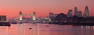
The River Thames, known alternatively in parts as the River Isis, is a river that flows through southern England including London. At 215 miles (346 km), it is the longest river entirely in England and the second-longest in the United Kingdom, after the River Severn.
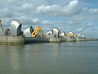
The Thames Barrier is a retractable barrier system built to protect the floodplain of most of Greater London from exceptionally high tides and storm surges moving up from the North Sea. It has been operational since 1982. When needed, it is closed (raised) during high tide; at low tide, it can be opened to restore the river's flow towards the sea. Built about 2 miles east of the Isle of Dogs, its northern bank is in Silvertown in the London Borough of Newham and its southern bank is in the New Charlton area of the Royal Borough of Greenwich.

Maidenhead is a market town in the Royal Borough of Windsor and Maidenhead in the county of Berkshire, England. It lies on the southwestern bank of the River Thames, which at this point forms the border with Buckinghamshire. In the 2021 Census, the Maidenhead built-up area had a population of 67,375. The town is 27 miles (43 km) west of Charing Cross, London and 13 miles (21 km) east-northeast of Reading.

The Royal Borough of Windsor and Maidenhead is a unitary authority area with royal borough status in Berkshire, England. The borough is named after its two largest towns of Maidenhead and Windsor. The borough also includes the towns of Ascot and Eton, plus numerous villages and surrounding rural areas. It is home to Windsor Castle, Eton College, Legoland Windsor and Ascot Racecourse. It is one of only four boroughs in England entitled to be prefixed royal, and the only one of them which is not a London borough.
The Environment Agency (EA) is a non-departmental public body, established in 1996 and sponsored by the United Kingdom government's Department for Environment, Food and Rural Affairs, with responsibilities relating to the protection and enhancement of the environment in England.

The Jubilee River is an artificial flood-relief channel in southern England. It is 11.6 km (7.2 mi) long and is on average 45 metres wide. It was constructed in the late 1990s and early 2000s to take overflow from the River Thames and so alleviate flooding to areas in and around the towns of Maidenhead, Windsor, and Eton in the counties of Berkshire and Buckinghamshire. It achieves this by taking water from the left bank of the Thames upstream of Boulter's Lock near Maidenhead and returning it via the north bank downstream of Eton. Although successful in its stated aims, residents of villages downstream, such as Wraysbury, claim it has increased flooding in those locations.

Bray, occasionally Bray on Thames, is a suburban village and civil parish in the Windsor and Maidenhead district, in the ceremonial county of Berkshire. It sits on the banks of the River Thames, to the southeast of Maidenhead with which it is contiguous. The village is mentioned in the comedic song "The Vicar of Bray". Bray contains two of the nine three-Michelin-starred restaurants in the United Kingdom and has several large business premises including Bray Studios at Water Oakley, where the first series of Hammer Horror films were produced.

The Thames Path is a National Trail following the River Thames from one of its sources near Kemble in Gloucestershire to the Woolwich foot tunnel, south east London. It is about 185 miles (298 km) long. A path was first proposed in 1948 but it only opened in 1996.

The winter of 1962–1963, known as the Big Freeze of 1963, was one of the coldest winters on record in the United Kingdom. Temperatures plummeted and lakes and rivers began to freeze over.

The River Bourne or the Chertsey Bourne is in Berkshire and Surrey; it runs from sources in Windsor Great Park and Swinley Forest through to the River Thames.

Royal Berkshire Fire and Rescue Service (RBFRS) is a statutory fire and rescue service covering the area of the ceremonial county of Berkshire in England. The fire service was formerly administered by Berkshire County Council, but when that was abolished the service became the responsibility of the Royal Berkshire Fire Authority, made up of representatives from the six unitary authorities of Bracknell Forest Borough Council, Reading Borough Council, Royal Borough of Windsor and Maidenhead, Slough Borough Council, West Berkshire Council, and Wokingham Borough Council.

Severe weather is any dangerous meteorological phenomenon with the potential to cause damage, serious social disruption, or loss of human life. These vary depending on the latitude, altitude, topography, and atmospheric conditions. High winds, hail, excessive precipitation, and wildfires are forms and effects, as are thunderstorms, downbursts, tornadoes, waterspouts, tropical cyclones, and extratropical cyclones. Regional and seasonal phenomena include blizzards,snowstorms, ice storms, and duststorms.

The winter of 1946–1947 was harsh in Europe, and noted for its adverse effects in the United Kingdom. It caused severe hardships in economic terms and living conditions in a country still recovering from the Second World War. There were massive disruptions of energy supply for homes, offices and factories. Animal herds froze or starved to death. People suffered from the persistent cold, and many businesses shut down temporarily. When warm weather returned, the ice thawed and flooding was severe in most low-lying areas.

The Maidenhead Waterways are a system of canals in Maidenhead, England. Formerly disused, plans to restore and upgrade them were announced in 2011. The works would initially make the waterways navigable by small craft, and over time by larger craft, as limitations to navigation are gradually removed.

Clewer Mill Stream is a narrow twisting backwater of the River Thames near Windsor, Berkshire, England, which leaves the main river at Bush Ait and rejoins just above Queen Elizabeth Bridge. It is about 1.5 miles long. Clewer Mill Stream is named after the watermill that it once drove.
The Abbey River is a right-bank backwater of the River Thames in England, in Chertsey, Surrey — in the town's northern green and blue buffers. The L-shaped conduit adjoins mixed-use flood plain: water-meadows landscaped for a golf course, a motorway and a fresh water treatment works on the island it creates, Laleham Burway to its east and north in turn. Its offtake from the Thames is at the apex of Penton Hook, Staines upon Thames below its lower weir close to the Chertsey-Thorpe boundary in the Borough of Runnymede. Its outfall is the weir pool of Chertsey Lock back into the Thames, visible from Chertsey Bridge.

Black Boy Island is an uninhabited island in the River Thames in England between the villages of Medmenham, Buckinghamshire and Hurley, Berkshire. It is situated alongside the small hamlet of Frogmill, on the southern side of the stretch of river above Hurley Lock, and is within the Royal Borough of Windsor and Maidenhead unitary authority.

The 2013–2014 United Kingdom winter floods saw areas of the United Kingdom inundated following severe storms. The south of England saw heavy rainfalls associated with these storms which caused widespread flooding, power cuts and major disruptions to transport. Economically, the worst affected areas were Somerset, Devon, Dorset and Cornwall in the south west and the Thames Valley in the south east.
The 2015 Windsor and Maidenhead Borough Council election took place on 7 May 2015 to elect all members of the council of the Royal Borough of Windsor and Maidenhead in England. This was on the same day as other local elections and coincided with the 2015 United Kingdom general election.

