2016 United Kingdom floods

Last updated

2016 United Kingdom floods
Generic UK flood image.jpg
Date7 June 2016 – 23 June 2016
LocationUnited Kingdom

In June 2016, parts of the United Kingdom were struck by serious flash floods. Starting on 7 June, thunderstorms caused intense rainfall in many locations across the country, particularly in the north of England and in London, causing repeated flash floods in several locations on a daily basis.

Contents

The flooding in the United Kingdom followed further flooding on the European mainland throughout May and June 2016, although the two events were caused by different weather systems.

Timeline of events

5 June

Approximately 90 minutes of torrential rainfall from 18:30 led to flash flooding across Southport and Birkdale in Merseyside. This resulted in several properties being flooded internally and widespread flooding of the highway.

7 June

Strong thunderstorms spawned by unusually warm weather caused heavy rainfall and flash flooding across the south of England, particularly in London, where 35 mm (1.4 inches) of rain was recorded in one hour, over two-thirds of the local average monthly rainfall total for June. The south-east London suburbs of Mitcham, Croydon and Wallington were worst affected, with floodwater up to two metres (6.6 ft) deep recorded on roads in Wallington. The London Fire Brigade received over 100 emergency calls and attended to three incidents of cars being swept away by floods, rescuing one person. [1]

Flooding also led to a loss of electrical power at Luton Airport. [1] In Penicuik in Scotland, a primary school and a leisure centre were flooded as well as numerous homes, with severe hail also being reported. [2] Flash floods were also reported in Dunstable town centre and other areas in Bedfordshire, as well as parts of West Yorkshire. [1]

8 June

In London, Covent Garden tube station was flooded, with adverse weather forcing the closure of a platform at London Victoria station, while several bus routes were diverted due to flooded roads. [3] Islington, Clapham and Battersea were the worst affected areas.

Severe flooding was also reported across the West Midlands, particularly in Wolverhampton. West Midlands Metro services were suspended due to flooding in Wednesbury, while flooding at Tame Bridge Parkway forced the suspension of National Rail services between Walsall and Rugeley Trent Valley and flooding between Rowley Regis and Old Hill forced the suspension of services between Birmingham Snow Hill and Stourbridge Junction. Additionally, both the M5 and A38 roads suffered disruption due to flooding. [4]

Greater Manchester was also affected by flooding, particularly in the towns of Oldham, Rochdale and Castleton just after 25 minutes of reported rain. In Middleton, rising floodwaters forced people to abandon their cars, while Middleton Shopping Centre was closed after water began to enter the entrance halls and some shops. Flooding was also reported at Middleton Arena and along the Broadway in Chadderton. [5] The Manchester Arndale was reported flooded as well.

Flash flooding in Windsor forced the evacuation of the Theatre Royal during an opening night performance after water began to enter the auditorium. [6] Flooding was also reported in Sheffield, [7] in Stoke-on-Trent, [8] and in parts of East Sussex. [9]

In Northern Ireland, a lightning strike at a primary school in Lisburn, County Antrim injured three people, including two critically. [1]

9 June

10 June

Further thunderstorms on 10 June lead to flash flooding mainly across northern England and the Midlands. Severe flooding was reported in parts of South Yorkshire, with Barnsley the worst affected area. in Staincross, numerous cars and a Stagecoach Yorkshire bus became stranded by rising floodwater, while several residential streets were hit by flash flooding in both Staincross and Grimethorpe, affecting dozens of homes. There were also reports of floodwater being contaminated with raw sewage in several areas, with houses being evacuated as they became contaminated. in Darton, floodwater several feet deep blocked roads around Darton railway station, particularly underneath the railway bridge. Flooding was also reported in Honeywell, Hoyland, Darfield, Birdwell and Worsbrough.[ citation needed ] There were also reports of flooding in Sheffield, particularly in the north-west of the city. A burst manhole cover caused the entirety of the dual carriageway A61 Penistone Road close to Hillsborough Stadium to become flooded with over a foot of water. [10]

In Nottinghamshire, thirty minutes of intense rainfall led to severe standing water flooding in West Bridgford and Long Eaton, while in Gedling, the Ouse Dyke broke its banks and flooded homes. [11] [12] Flooding also affected settlements across the border in Leicestershire, with heavy rainfall flooding businesses on the High Street in the centre of the village of Syston. [13]

Flooding was also reported in parts of Merseyside and Cheshire, including at Cheshire Oaks Designer Outlet and in parts of Liverpool. [14] Emergency services attended a number of flood-related incidents in Ellesmere Port, where flash floods struck the town centre and the suburbs of Little Sutton and Great Sutton, flooding dozens of homes and businesses with water up to a foot deep and forcing evacuations. A local primary school closed early after part of the roof collapsed due to heavy rainfall, and several classrooms were flooded. A sinkhole also opened up on a residential street as a result of the intense rainfall. [15]

In Greater Manchester, parts of Oldham and Rochdale were struck by flash flooding for the second time in three days. Flooding was also reported in parts of Manchester itself. Both the M60 and M62 motorways were flooded, leading to travel disruption. Homes in Ashton under Lyne were flooded with up to a metre of water, and there were also reports of flooding in the Failsworth area of Rochdale. [16]

In the West Midlands, flooding caused disruption in Cannock, including at the Cannock Shopping Centre, which was closed due to flooding in the area. Roads around Cannock railway station were flooded, with two cars becoming stranded. [17]

Minor flooding was also reported at Deeping St Nicholas in Lincolnshire, with five homes affected. [18]

11 June

Parts of London were again struck by flash flooding on 11 June. Several feet of water caused flooding in numerous areas, particularly Purley, where cars were left stranded and buses were diverted. [19] [20] Flooding forced the closure of the A23 in south London, causing travel disruption. [21]

In Greater Manchester, flooding was reported in Stockport, Hazel Grove and Offerton, with roads being transformed into rivers. [22] Arriva Rail North train services were suspended between Buxton and Hazel Grove after flooding and landslides affected the Buxton Line railway. [23] Rail replacement buses were provided as a result of the disruption. [24] National Rail later confirmed that the line would remain closed until the end of service on 12 June while urgent repair work was carried out. [25] There were also reports of flooding in Whaley Bridge, with firefighters rescuing one person from their car. [26]

There was further flooding at the Download Festival at Castle Donington, with several feet of water flooding an entire field where hundreds of tents had been set up. [27] Heavy rainfall caused part of the roof of an ASDA supermarket to collapse in Telford as numerous roads were flooded in the town. [28] In Saltney in Cheshire, flooding closed the local High Street as four cars became trapped in floodwater beneath the railway bridge, where there was water several feet deep. There were also reports of floodwater entering several pubs and businesses in Chester. [29]

12 June

12 June saw some of the worst flooding to date. There was widespread flooding across Greater Manchester, Merseyside and Cheshire, with dozens of homes affected and many people having to be evacuated to emergency shelters by the fire brigade using boats, particularly in Poynton. [30] [31] There were further landslides on the railway line between Stockport and Disley, forcing it to close again just hours after reopening; it was later confirmed that the line would remain closed until at least 19 June while repair work was carried out. [25] [32]

There was also flooding in parts of Gloucestershire, including at Cheltenham Spa railway station and across residential areas of Cheltenham, with disruption to electricity supplies occurring across the county. [33] In Chelmsford in Essex, several homes were flooded with water up to knee depth. [34]

One person was injured during thunderstorms in Bedfordshire after their home in Flitwick was struck by lightning. The Bedfordshire Fire Brigade received over 40 flood-related emergency calls across the county. In Stotfold and Ampthill, a brook burst its banks and a storm drain failed, leading to severe flooding. Flooding also occurred in Cranfield, Barton-le-Clay, Lower Stondon and Lidlington. [35]

13 June

Heavy rainfall at the Cheshire Oaks Designer Outlet caused draining systems to fail, causing flooding inside numerous stores, with the roof of at least one store partially collapsing inside. [36] Flooding was also reported across Lancashire, particularly in Lancaster and Morecambe, with up to four feet of water blocking roads in places. At least one car was left stranded by the flooding, with emergency services being called out to deal with the incident. [37]

In Hertfordshire, flooding was reported in Letchworth Garden City, Stotfold and Hitchin. The outdoor swimming pool in Letchworth overflowed, while several streams burst their banks, and sewage systems were overwhelmed, flooding areas with raw sewage. [38] [39] The Center Parcs at Woburn Forest in Bedfordshire was also flooded, with seven holiday lodges having to be evacuated. [40]

14 June

Heavy rainfall caused serious disruption to rail services across the Midlands. Trains were suspended for several hours between Hednesford and Rugeley Trent Valley due to flooding, affecting London Midland services. [41] There was also serious disruption to London Midland and Chiltern Railways services between Birmingham Snow Hill and Stourbridge Junction due to flooding near The Hawthorns. [42]

In Birmingham, the Bullring and Mailbox shopping centres were forced to close due to flooding, which also affected the Grand Central shopping plaza above Birmingham New Street railway station, with water leaking through the roof and flooding the malls. Bus and Midland Metro services were also affected, while the Bull Ring Indoor Market was forced to close. Flooding was also reported in Erdington, where a car overturned. [43] The M5 motorway was flooded between Junctions 1 and 2. [44] A 'major incident' was declared at Heartlands Hospital after flooding struck the accident and emergency department. [45] Flooding was also reported across West Bromwich, including outside The Hawthorns, although the stadium itself appeared unaffected. There was also flooding in parts of Smethwick and areas in nearby Staffordshire. [46]

Further flooding occurred in Shropshire. Several tornadoes touched down close to Shrewsbury, although it remained over rural areas and caused no reported damage. Flooding was reported in Newport, Telford, Lognor, Ketley and Donnington. [47] There were also reports of flooding in north Wales, particularly in Denbighshire and Wrexham; [48] in Greater Manchester; [49] and in Kettering, Northamptonshire. [50]

16 June

Flash flooding due to severe thunderstorms once again brought disruption to the West Midlands transport network. Significant flooding at Lye once again caused London Midland and Chiltern Railways services to be delayed and cancelled between Kidderminster and Birmingham Snow Hill, whilst several bus routes were diverted due to flooding, in particular in the area surrounding the Merry Hill shopping centre, where several shops had been forced to shut due to large amounts of water coming through the ceiling and the bus station was also flooded. [51] [52]

23 June

Flash flooding particularly affecting London and South East England, caused widespread transport disruption. [53]

See also

Related Research Articles

<span class="mw-page-title-main">Floods in the United States (2000–present)</span>

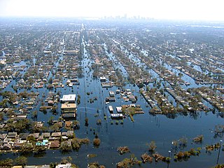
Floods in the United States (2000–present) is a list of flood events which were of significant impact to the country during the 21st century, since 2000. Floods are generally caused by excessive rainfall, excessive snowmelt, storm surge from hurricanes, and dam failure.

<span class="mw-page-title-main">2007 United Kingdom floods</span>

A series of large floods occurred in parts of the United Kingdom during the summer of 2007. The worst of the flooding occurred across Scotland on 14 June; East Yorkshire and the Midlands on 15 June; Yorkshire, the Midlands, Gloucestershire, Herefordshire and Worcestershire on 25 June; and Gloucestershire, Herefordshire, Worcestershire, Oxfordshire, Berkshire and South Wales on 28 July 2007.

<span class="mw-page-title-main">2008 Ireland floods</span>

The 2008 Irish flash floods were a series of flash floods that occurred across the island of Ireland in August 2008. The floods and related weather conditions primarily affected the following counties; Limerick, Cork, Dublin, Antrim, Carlow, Galway, Laois, Louth, Meath, Kildare, Kilkenny, Tipperary, Offaly, Sligo and Donegal. Parts of Ireland's large urban centres, including Dublin and Belfast, were submerged, whilst Carlow town has experienced some of the worst flooding in the country. One person died; 31-year-old dad-of-one Przemyslaw Jablonski. He went missing in the River Fergus, in Ennis, and was found 6 days later in the same river. He was pronounced dead at the scene.

Occasionally, some parts of Singapore are inundated by floods, usually in the form of flash floods that came about due to intense rainfall over a short period of time. Floods in Singapore are much less severe than floods in other countries, often only lasting a few hours before dissipating on its own.

The 2010 Victorian floods were a widespread series of flood events across the state of Victoria, Australia. The floods, which followed heavy rain across southeastern Australia in early September 2010, caused the inundation of about 250 homes, hundreds of evacuations and millions of dollars of damage. Weather warnings were initially issued for Victoria on Thursday 2 September and rain began to fall on the Friday, continuing through the weekend to Tuesday. Heavy rain fell in most regions of the state, particularly at higher altitudes in the state's west and northeast, flooding the upper reaches of many of Victoria's major rivers. A state of emergency was declared with State Emergency Service crews arriving from Queensland, South Australia and Tasmania. The floods proceeded an extensive drought period that had effected the entirety of Australia.

<span class="mw-page-title-main">2012 Great Britain and Ireland floods</span>

The 2012 Great Britain and Ireland floods were a series of weather events that affected parts of Great Britain and Ireland periodically during the course of 2012 and on through the winter into 2013. The beginning of 2012 saw much of the United Kingdom experiencing droughts and a heat wave in March. A series of low pressure systems steered by the jet stream brought the wettest April in 100 years, and flooding across Britain and Ireland. Continuing through May and leading to the wettest beginning to June in 150 years, with flooding and extreme events occurring periodically throughout Britain and parts of Atlantic Europe.

The 2013 Southeastern United States floods were ongoing flooding across the southeastern U.S. Flash floods began on the morning of July 2 and continued through Independence Day and into the next day. The hardest-hit areas as of Friday afternoon are the Florida Panhandle, northwest Alabama and the area around Columbus, Mississippi. A plume of tropical moisture caused heavy rain to train over the same areas, for more than 36 hours in some cases, leading to flash flooding.

<span class="mw-page-title-main">Storm Desmond</span> Extratropical cyclone in December 2015

Storm Desmond was an extratropical cyclone and fourth named storm of the 2015–16 UK and Ireland windstorm season, notable for directing a plume of moist air, known as an atmospheric river, which brought record amounts of orographic rainfall to upland areas of northern Atlantic Europe and subsequent major floods.

<span class="mw-page-title-main">2015–16 Great Britain and Ireland floods</span> Flooding in Great Britain and Ireland during the winter of late 2015 and early 2016

The 2015–2016 Great Britain and Ireland floods were a series of heavy rainfall events which led to flooding during the winter of late 2015 and early 2016. 11 named storms produced record level rainfall from November 2015 - March 2016 in both monthly and seasonal accumulation records.

<span class="mw-page-title-main">Effects of Hurricane Floyd in New Jersey</span> Aftermath of hurricane in New Jersey

Hurricane Floyd in 1999 was the costliest natural disaster in New Jersey's history, until it was surpassed by Hurricane Irene in 2011. Damage in the state totaled $250 million (1999 USD), much of it in Somerset and Bergen counties. Seven people died in New Jersey during Floyd's passage – six due to drowning, and one in a traffic accident. A police lieutenant took his life after coordinating floodwater rescues for nearly 48 hours.

<span class="mw-page-title-main">Potential Tropical Cyclone Ten</span> Tenth designated tropical disturbance during the 2017 Atlantic hurricane season

Potential Tropical Cyclone Ten was a damaging storm that was the tenth tropical disturbance designated by the National Hurricane Center (NHC) during the 2017 Atlantic hurricane season. The disturbance was deemed to have a very high chance of becoming a tropical cyclone while posing a threat to populated areas and was designated a "Potential Tropical Cyclone". The storm caused flooding and brought tropical storm-force winds to parts of the Southeastern United States and the Mid-Atlantic states, particularly Florida and the Carolinas, before going on to affect parts of Atlantic Canada. Potential Tropical Cyclone Ten was the tenth storm that had advisories issued on it by the NHC in 2017, and the only such system that failed to fully develop into a tropical cyclone during that Atlantic hurricane season. Potential Tropical Cyclone Ten originated from a tropical wave that moved off the coast of West Africa on August 13. The disturbance slowly tracked its way westward across the Atlantic Ocean, before reaching Florida in late August. The disturbance came close to developing into a tropical storm while it was situated off the coast of the Carolinas; however, strong wind shear and outflow from Hurricane Harvey prevented the storm from organizing into a tropical cyclone. The system transitioned into an extratropical cyclone instead, and became a strong hurricane-force low to the south of Newfoundland, before being absorbed by another extratropical system near Iceland on September 3.

<span class="mw-page-title-main">2019–20 United Kingdom floods</span> Severe flooding events in the United Kingdom over the winter of 2019–2020

Between November 2019 and February 2020, severe winter flooding occurred across the United Kingdom. The first wave of flooding occurred in November 2019, mainly affecting Yorkshire and the Humber, the East Midlands and the West Midlands. Further isolated flooding incidents were reported in December and January, before the second main wave of flooding, caused by Storms Ciara and Dennis, occurred in February 2020. The excessive rainfall resulted in the wettest February since records began, in 1766, in England and Wales with an average of 169.6 millimetres (6.68 in) falling across the regions, beating the record from 1833.

<span class="mw-page-title-main">2019 Yorkshire Dales floods</span> July 2019 floods in the Yorkshire Dales, England

In July 2019, parts of the Yorkshire Dales, in North Yorkshire, England, were subjected to above average rainfall for the time of year. The flash-flooding that followed affected many communities destroying bridges, sweeping roads away, causing landslips on railway lines and resulting in at least one public event being cancelled. The flooding even inundated the fire station in the town of Leyburn, in Wensleydale, whilst the crew were out helping those in need. The recovery took many weeks and months, with immediate help by the rescue services being bolstered by British Army personnel who assisted with the clean up.

<span class="mw-page-title-main">Tropical Storm Claudette (2021)</span> Atlantic tropical storm in 2021

Tropical Storm Claudette was a weak tropical cyclone that caused heavy rain and tornadoes across the Southeastern United States in June 2021, leading to severe damage. The third named storm of the 2021 Atlantic hurricane season, Claudette originated from a broad trough of low pressure over the Bay of Campeche on June 12. The disturbance moved erratically over the region for the next several days, before proceeding northward with little development due to unfavorable upper-level winds and land interaction. Despite this, the National Hurricane Center (NHC) initiated advisories on it as a Potential Tropical Cyclone late on June 17, due to its imminent threat to land. The disturbance finally organized into Tropical Storm Claudette at 00:00 UTC on June 19 just before landfall in southeast Louisiana. Claudette weakened to a depression as it turned east-northeastward before moving through Mississippi, Alabama, Georgia, and South Carolina. Baroclinic forcing then caused Claudette to reintensify into a tropical storm over North Carolina early on June 21 before it accelerated into the Atlantic Ocean later that day. Soon afterward, it degenerated into a low-pressure trough on the same day, before being absorbed into another extratropical cyclone on the next day.

<span class="mw-page-title-main">2021 Tennessee floods</span> Natural disaster

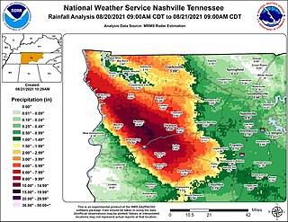
Between midnight and 10:00 am CDT on Saturday, August 21, 2021, very heavy rainfall resulted in widespread flash flooding across western Middle Tennessee, including the town of Waverly. During the event, much of a five-county area received up to a quarter of normal annual rainfall in under twelve hours, as much as 10 to 15 inches. In a situation described as catastrophic, Waverly was severely damaged by floodwater, with hundreds of homes and dozens of businesses destroyed and swept away. Numerous people became trapped, leading to widespread water rescues. The event resulted in 19 fatalities in Waverly, with another in nearby Hurricane Mills, and is regarded as one of the worst natural disasters in Tennessee history. The event broke the 24-hour rainfall record in Tennessee, with over 20 inches (510 mm) of rain falling in McEwen. Flooding also occurred in parts of western Kentucky, but to a much lesser extent.

<span class="mw-page-title-main">Tropical Storm Mindy</span> Atlantic tropical storm in 2021

Tropical Storm Mindy was a short-lived tropical storm which affected much of Mexico and the Southeastern United States in September 2021. The thirteenth tropical storm of the 2021 Atlantic hurricane season, Mindy originated from a tropical wave which entered the Atlantic Ocean from the west coast of Africa on August 22. The wave traveled westward across the Atlantic, breaking apart for the first time on August 27. After moving through Central America breaking apart once more on September 2. The northern part of the wave moved into the Gulf of Mexico on September 5, moving gradually northward between two mid-level ridges. On September 8, the wave began showing signs of organization and gale-force winds, becoming Tropical Storm Mindy southwest of Apalachicola, Florida. Mindy intensified before landfall, attaining a peak intensity with maximum sustained winds of 60 mph (97 km/h) and a minimum barometric pressure of 1,000 mbar (30 inHg) at 01:15 UTC on September 9; as the cyclone made landfall on St. Vincent Island, Florida. The storm rapidly weakened inland before entering the Atlantic and being absorbed by a baroclinic system on September 11.

<span class="mw-page-title-main">July–August 2022 United States floods</span> Natural disaster

Beginning on July 24, 2022, and lasting for a week, many flash flooding events hit several areas of the United States. These areas included parts of Missouri and Illinois, especially Greater St. Louis, Eastern Kentucky, Southwest Virginia, parts of West Virginia, and the Las Vegas Valley. Several rounds of severe thunderstorms began in Missouri on July 24, culminating during July 25 and 26, when St. Louis broke its previous 1915 record for the most rainfall in a span of 24 hours. Governor Mike Parson declared a state of emergency on July 26. Over one hundred people were rescued from floods, and two people were killed. Late on July 27 and into July 28, historic flooding began in central Appalachia, particularly in Kentucky, where a state of emergency was declared. A total of 38 people were killed in Kentucky as a direct result of flooding, with a 39th fatality occurring days later during cleanup efforts and a 40th coming in September during cleanup efforts in Pike County.

<span class="mw-page-title-main">2022 United Kingdom floods</span> Natural disaster in the United Kingdom

Throughout 2022, between February and November, areas of the United Kingdom experienced significant flooding. The first wave of flooding occurred in February as Storm Franklin caused severe disruption across the country.

References

  1. 1 2 3 4 "Flash flooding causes chaos in parts of England". BBC News. 7 June 2016. Archived from the original on 11 June 2016. Retrieved 16 July 2021.
  2. "Lightning strike and flash flooding during downpours". BBC News. 7 June 2016. Archived from the original on 9 June 2016. Retrieved 14 June 2016.
  3. Mann, Sebastian (8 June 2016). "Londoners soaked in second day of flash floods". Evening Standard. Archived from the original on 1 July 2016. Retrieved 14 June 2016.
  4. "Flooding causes travel disruption across West Midlands". ITV News. 8 June 2016. Archived from the original on 13 June 2016. Retrieved 14 June 2016.
  5. Yarwood, Sam (8 June 2016). "Watch as man abandons car due to flash flooding in Middleton". Manchester Evening News. Archived from the original on 11 June 2016. Retrieved 14 June 2016.
  6. "Windsor theatre evacuated on opening night due to flash flooding". BBC News. 8 June 2016. Archived from the original on 11 June 2016. Retrieved 14 June 2016.
  7. "Enjoy current sun ... thunder, rain and hail await!". The Star . JPIMedia Publishing. 7 June 2016. Archived from the original on 16 July 2021. Retrieved 14 June 2016.
  8. "Three Stoke-on-Trent roads affected by flooding". Stoke Sentinel. 8 June 2016. Retrieved 14 June 2016.[ dead link ]
  9. "A month's rain falls in minutes causing flash flooding". The Argus. 8 June 2016. Archived from the original on 16 July 2021. Retrieved 14 June 2016.
  10. "Live incident: Flash flooding on Penistone Road". The Star. 10 June 2016. Archived from the original on 30 August 2017. Retrieved 30 August 2017.
  11. "Flash floods batter East Midlands". ITV News. 10 June 2016. Retrieved 30 August 2017.
  12. [ dead link ]
  13. [ dead link ]
  14. "Rain storm brings flash flooding to Merseyside and Cheshire | Granada - ITV News". Itv.com. 10 June 2016. Retrieved 30 August 2017.
  15. David Holmes (10 June 2016). "Ellesmere Port deluge leads to flooding". Chester Chronicle. Retrieved 30 August 2017.
  16. Todd Fitzgerald (10 June 2016). "Flash floods hit Greater Manchester following heavy downpours". Manchester Evening News. Retrieved 30 August 2017.
  17. "Pictures and video: Cannock hit by flash flooding". www.expressandstar.com.
  18. [ dead link ]
  19. "Flash floods hit Purley again". Croydon Advertiser. 11 June 2016. Retrieved 30 August 2017.[ permanent dead link ]
  20. "London flooding: Flash floods hit Purley after torrential rain". London Evening Standard. 11 June 2016. Retrieved 30 August 2017.
  21. "London Weather: Purley Flash Flooding Causes Chaos As Severe Warning Issued". Huffington Post. Retrieved 30 August 2017.
  22. Beth Abbit (11 June 2016). "Streets turns into RIVER in shocking footage after torrential downpour causes flash flooding". Daily Mirror. Retrieved 30 August 2017.
  23. [ dead link ]
  24. "TRAVEL UPDATE: No trains between Buxton and Hazel Grove until June 20 after flooding". Buxton Advertiser. Archived from the original on 12 June 2016. Retrieved 30 August 2017.
  25. 1 2 "National Rail Enquiries - Service Alteration Details". Archived from the original on 15 June 2016. Retrieved 14 June 2016.
  26. "Person rescued after car enters water at Whaley Bridge". Buxton Advertiser. 9 June 2016. Archived from the original on 9 August 2016. Retrieved 30 August 2017.
  27. [ dead link ]
  28. "Telford flash flood leaves residents trapped and closes store". www.shropshirestar.com.
  29. David Holmes. "Saltney High Street cut off by flash flooding". Chester Chronicle. Retrieved 30 August 2017.
  30. "Flash floods strike Poynton, Disley and Stockport - BBC News". Bbc.co.uk. Retrieved 30 August 2017.
  31. "Clean up under way after heavy rain caused flash flooding". ITV News. 12 June 2016. Retrieved 30 August 2017.
  32. "Flash floods close Buxton and Hazel Grove railway line until Sunday". BBC News. Retrieved 30 August 2017.
  33. "LIVE: The clean-up continues after flash-flooding brought chaos to Gloucestershire | Gloucestershire Live". Archived from the original on 13 June 2016. Retrieved 14 June 2016.
  34. "Neighbouring Chelmsford homes flooded in storm have left families devastated". Essexchronicle.co.uk. 13 June 2016. Retrieved 30 August 2017.[ permanent dead link ]
  35. "Man injured in lightning strike as storms cause flooding". ITV News. 13 June 2016. Retrieved 30 August 2017.
  36. "WATCH: Flash flooding at Cheshire Oaks outlet". ITV News. 14 June 2016. Retrieved 30 August 2017.
  37. "Torrisholme Road partly closed after Lancaster flooding". Lancaster Guardian. 13 June 2016. Retrieved 30 August 2017.
  38. JP Asher. "'Never seen anything like it' – Heavy rain floods roads in Letchworth, Hitchin, Stotfold and more". The Comet. Retrieved 30 August 2017.
  39. Perez, Cristina (13 June 2016). "Heavy rain causes flooding in Hertfordshire". Hertfordshire Mercury. Retrieved 30 August 2017.[ permanent dead link ]
  40. "Woburn Center Parcs flooded in heavy thunderstorms". BBC News. 13 June 2016. Retrieved 30 August 2017.
  41. "National Rail Enquiries - Service Alteration Details". Archived from the original on 21 September 2016. Retrieved 14 June 2016.
  42. "National Rail Enquiries - Service Alteration Details". Archived from the original on 18 June 2016. Retrieved 14 June 2016.
  43. Graeme Brown (14 June 2016). "Birmingham floods: Parts of the Bullring and Mailbox closed". Birmingham Mail. Retrieved 30 August 2017.
  44. Graeme Brown (14 June 2016). "Birmingham floods: Buses and Metro services cancelled and Bull Ring markets close". Birmingham Mail. Retrieved 30 August 2017.
  45. Anuji Varma (14 June 2016). "Major incident declared at Heartlands hospital's accident and emergency department". Birmingham Mail. Retrieved 30 August 2017.
  46. "West Midlands flash flooding: Torrential rain swamps roads for the SECOND time in a week". www.expressandstar.com.
  47. "Video and pictures: Flash flooding hits Shropshire again as 'twister' appears over Shrewsbury". www.shropshirestar.com.
  48. Sarah Hodgson (14 June 2016). "Recap: Flooding as storms batter North Wales". Daily Post. Retrieved 30 August 2017.
  49. Alexandra Rucki (14 June 2016). "Manchester weather: Flood warnings issued as heavy rain expected today". Manchester Evening News. Retrieved 30 August 2017.
  50. "Concerns after flash flooding shuts Kettering street". Northamptonshire Telegraph. 14 June 2016. Archived from the original on 17 June 2016. Retrieved 30 August 2017.
  51. "NX West Midlands" . Retrieved 16 June 2016.[ permanent dead link ]
  52. "Network Rail Twitter" . Retrieved 16 June 2016.
  53. "Second Round Of Weather Chaos Hits UK". Sky News. 23 June 2016. Retrieved 25 June 2016.