
Nottinghamshire is a ceremonial county in the East Midlands of England. The county borders South Yorkshire to the north-west, Lincolnshire to the east, Leicestershire to the south, and Derbyshire to the west. The largest settlement is the city of Nottingham (323,632), which is also the county town.
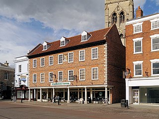
Newark-on-Trent or Newark is a market town and civil parish in the Newark and Sherwood district in Nottinghamshire, England. It is on the River Trent, and was historically a major inland port. The A1 road bypasses the town on the line of the ancient Great North Road. The town's origins are likely to be Roman, as it lies on a major Roman road, the Fosse Way. It grew up around Newark Castle, St Mary Magdalene church and later developed as a centre for the wool and cloth trades.

The Trent is the third longest river in the United Kingdom. Its source is in Staffordshire, on the southern edge of Biddulph Moor. It flows through and drains the North Midlands into the Humber Estuary. The river is known for dramatic flooding after storms and spring snowmelt, which in the past often caused the river to change course.
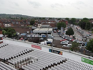
Rushcliffe is a local government district with borough status in south Nottinghamshire, England. Its council is based in West Bridgford. The borough also includes the towns of Bingham and Cotgrave as well as numerous villages and surrounding rural areas. Some of the built-up areas in the north-west of the borough, including West Bridgford, form part of the Nottingham Urban Area.

West Bridgford is a town and the administrative centre of the Borough of Rushcliffe, in the county of Nottinghamshire, England. It lies south of Nottingham city centre, east of Wilford, north of Ruddington and west of Radcliffe-on-Trent; it is also south-west of Colwick and south-east of Beeston, which are on the opposite bank of the River Trent. The town is part of the Nottingham Urban Area and had a population of 36,487 in the 2021 Census.

The River Devon is a tributary of the River Trent, which rises in Leicestershire and joins the Trent at Newark in Nottinghamshire, England. In its upper reaches, it supplies Knipton Reservoir, which was built to supply water to the Grantham Canal, and Belvoir Lakes, designed by Capability Brown. It passes under the Grantham Canal, and then through Bottesford, where it is spanned by five railway bridges, only one of which is still used for its original purpose. On the outskirts of Newark, it passes by two Civil War structures, and just before it joins the Trent it becomes navigable, with a marina located on the west bank. Its name is pronounced "Deevon", not as spelt.

The River Leen is a 15-mile (24 km) long tributary of the River Trent that flows through Nottinghamshire, and the city of Nottingham in the East Midlands of England.

Stoke Bardolph is a village and civil parish in the Gedling district of Nottinghamshire, England. The population of the civil parish taken at the 2011 census was 170, increasing to 598 residents at the 2021 census. It is to the east of Nottingham, and on the west bank of the River Trent. Nearby places include Burton Joyce and Radcliffe on Trent.

Besthorpe is a small village in north-east Nottinghamshire close to the border with Lincolnshire. It is a civil parish in the Newark & Sherwood district of Nottinghamshire. The population of the civil parish as of the 2011 census was 195, increasing to 212 at the 2021 census. The village is on the A1133 between Newark and Gainsborough, and is 1.5 miles north of the larger village of Collingham, north east of Newark on Trent. The village lies 1 mile east of the River Trent and the River Fleet flows south to east parallel with the village & A1133. Besthorpe acquired Conservation Village status in 2006 because it has maintained much of its original layout focused on Low Road and the Green.

Plumtree is a village and civil parish in the borough of Rushcliffe, Nottinghamshire. At the time of the 2001 census it had a population of 221, increasing to 246 at the 2011 census, and 259 at the 2021 census. It is situated 5 miles south east of Nottingham, between the villages of Tollerton and Keyworth. Some of the farming land around the village is owned by the Duchy of Cornwall. The parish church of St Mary has a Norman tower on Saxon foundations, which were found when the tower was rebuilt in 1906. The nave is of 13th-century date. The north aisle was rebuilt and extended with stone from Nottingham's medieval Trent Bridge in 1873. Edward Hagarty Parry (1855–1931), an association footballer who captained Old Carthusians F.C. when they won the 1881 FA Cup Final against Old Etonians, is buried in the churchyard.

Farndon is a small village and civil parish in the Newark and Sherwood district of Nottinghamshire, England. It lies along the historic Fosse road on the banks of the River Trent and is 3 miles (4 km) south-west of Newark-on-Trent. The population of the civil parish as of the 2011 census was 2,405, this increased to 2,479 at the 2021 census. The A46 road previously ran through the village until the development of a new dual carriageway bypass.
Gunthorpe is a village and civil parish in Nottinghamshire, England. Its population was 740 at the 2021 census. It lies on the left bank of the River Trent. Gunthorpe Bridge on the A6097 is the only road crossing of the river between Newark and Nottingham. It is one of five places in England with the same name.

Trent Bridge is an iron and stone road bridge across the River Trent in Nottingham, England UK. It is the principal river crossing for entrance to the city from the south, although the upstream Clifton Bridge is both larger and busier.

Cromwell is a village and civil parish in Nottinghamshire, England. It is located 5 miles (8 km) north of Newark. According to the 2001 census it had a population of 188, increasing to 232 at the 2011 census, and 271 at the 2021 census.
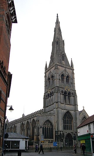
St Mary Magdalene Church, Newark-on-Trent is the parish church of Newark-on-Trent in Nottinghamshire, England. It is dedicated to Mary Magdalene and is the tallest structure in the town.

Marriott Ogle Tarbotton MICE, FGS, FRMS, was born in Leeds on 6 December 1834 and died in Nottingham on 6 March 1887. He was Borough Engineer for Nottingham from 1859.

The City of Nottingham Water Department (1912–1974), formerly the Nottingham Corporation Water Department (1880–1912), was responsible for the supply of water to Nottingham from 1880 to 1974. The first water supply company in the town was the Nottingham Waterworks Company, established in 1696, which took water from the River Leen, and later from springs at Scotholme, when the river became polluted. Other companies were set up in the late 18th century and in 1824, while in 1826 the Trent Water Company was established. They employed Thomas Hawksley as their engineer, who became one of the great water engineers of the period, and Nottingham had the first constant pressurised water supply system in the country. The various companies amalgamated in 1845, and Hawksley remained as the consulting engineer until 1879.
The following is a timeline of the history of the city of Nottingham, England.
Carrington Street is a street in Nottingham city centre between Nottingham station and Broadmarsh.

Richard Allen was a stationer and publisher in Nottingham.
