Trent Bridge (bridge)

Last updated

Trent Bridge
TrentBridge2022.jpg
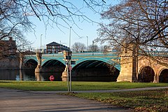
View of Trent Bridge from the bank of the River Trent, West Bridgford
Coordinates 52°56′18.4″N1°08′10.9″W / 52.938444°N 1.136361°W / 52.938444; -1.136361
CarriesRoad traffic ( A60 , single carriageway)
Crosses River Trent
Locale Nottingham, Nottinghamshire, England
Heritage status Grade II listed
Characteristics
MaterialIron and stone
Width40 feet (12 m)
Longest span100 feet (30 m)
History
Designer Marriott Ogle Tarbotton
Constructed by Andrew Handyside and Company
Construction start1868
Construction end1871
Location
Trent Bridge (bridge)

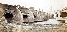
Trent Bridge is an iron and stone road bridge across the River Trent in Nottingham, England. It is the principal river crossing for entrance to the city from the south, although the upstream Clifton Bridge is both larger and busier.

Contents

History

Medieval bridge

The first bridge is thought to have been constructed on the site in 920. A second bridge which was started in 1156 had more than 20 stone arches and a chapel dedicated to St. James [1] at one end. It was maintained by a religious organisation. On 21 February 1551 the responsibility for repair passed to Nottingham Corporation, through a Royal Charter which created the Bridge Estate.

It was known as Hethbeth bridge, Heath-beth bridge, or Heck-beck bridge. [2]

This bridge was damaged by floods several times, and the northern half was washed away in 1683. The repaired bridge had fifteen arches across the river and flood areas, giving openings covering 347 ft in a total length of 538 ft. [3] Although it was repaired, the foundations had become unsafe and a project to replace it was started in the 1860s.

Modern bridge

Old and new bridges pictured together in 1871 Old and new trent bridges 1871.jpg
Old and new bridges pictured together in 1871

The bridge was designed by Marriott Ogle Tarbotton. [4] Construction started in 1868 and was completed in 1871 by Derbyshire iron maker, Andrew Handyside. The general contractor was Benton and Woodiwiss of Derby. It was completed for a cost of £30,000 (equivalent to £2,971,765 as of 2021). [5] There were three main cast iron arch spans each 100 feet (30 m) braced by wrought iron girders. The width between the parapets was 40 feet (12 m). It is a Grade II listed building. [6] The carving on the bridge was executed by Mawer and Ingle of Leeds. [7]

The new Trent Bridge formed part of a series of works along the banks of the river to improve flood defences by the construction of stepped, stone embankments.

Between 1924 and 1926 the bridge was widened to 80 ft by the Cleveland Bridge & Engineering Company. [3]

Bridge Estate

Two arches from the old bridge are still preserved on the south bank of the river . Old Trent Bridge-geograph-3441254-by-John-Sutton.jpg
Two arches from the old bridge are still preserved on the south bank of the river .
Plan showing proposed position of the new bridge relative to the old bridge (1869) 50 of 'History of the Old Trent Bridge, with a descriptive account of the New Bridge, Nottingham. Illustrated by photographs' (11093917323).jpg
Plan showing proposed position of the new bridge relative to the old bridge (1869)

The Bridge Estate was created by a Royal Charter of King Edward VI on 21 February 1551 with Nottingham Corporation as Trustee. The objective was to provide funds to maintain and repair the Bridge.

In 1882 the funds exceed the requirement of the objective, and three new objectives were agreed:

In 1945 the Bridge Estate was registered as Charity 220716 with the Charity Commissioners.

Flood marks

Trent Bridge flood marks Archway Under Trent Bridge - geograph.org.uk - 608013.jpg
Trent Bridge flood marks
Another view of the Trent Bridge flood marks Flood markers, Trent Bridge - geograph.org.uk - 985405.jpg
Another view of the Trent Bridge flood marks

On the northern abutment of the bridge, the high water marks reached by floods since 1852 have been carved into the stonework. This practice was started during the period when the Hethbeth bridge still existed, and those earlier marks were transferred onto the new bridge. To enable a comparison to be made with the peak levels, a graduated series of heights in feet above sea level has also been added. [8] [9] [10]

The highest flood mark is for the October 1875 flood, but the larger 1795 Candlemas flood, has been attributed with a height at the bridge of 24.55 metres (80.5 ft). Normal water level which is controlled by Holmes Sluices some 4 kilometres (2.5 mi) downstream, is 20.7 metres (68 ft). [8] [9] [11]

The bridge is one of Nottingham's most famous landmarks and sits at the heart of Nottingham's sporting district. The bridge lends its name to the nearby Nottinghamshire County Cricket Club Trent Bridge stadium, one of England's biggest and most famous cricket grounds. Nottingham Forest FC's City Ground stadium and Notts County FC's Meadow Lane stadium are nearby. The bridge has also been used in as the backdrop for the regional BBC East Midlands Today and ITV Central News.[ citation needed ]

The Riverbank public house overlooks the bridge in its former tollhouse.[ citation needed ]

In December 2002, the Nottingham Princess river cruise boat crashed into the central column of the bridge when it lost control in strong currents. [11]

Next road crossing upstream River Trent Next road crossing downstream
Clifton Bridge (Nottingham)
A52
Trent Bridge
A60
Grid reference SK581382
Lady Bay Bridge
A6011
Next footbridge upstreamRiver TrentNext footbridge downstream
Wilford Suspension Bridge Trent Bridge
A60
Grid reference SK581382
Lady Bay Bridge

See also

Related Research Articles

<span class="mw-page-title-main">River Ancholme</span> River in Lincolnshire, England

The River Ancholme is a river in Lincolnshire, England, and a tributary of the Humber. It rises at Ancholme Head, a spring just north of the village of Ingham and immediately west of the Roman Road, Ermine Street. It flows east and then north to Bishopbridge west of Market Rasen, where it is joined by the Rase. North of there it flows through the market town of Brigg before draining into the Humber at South Ferriby. It drains a large part of northern Lincolnshire between the Trent and the North Sea.

<span class="mw-page-title-main">River Avon, Bristol</span> River in the south west of England

The River Avon is a river in the southwest of England. To distinguish it from a number of other rivers of the same name, it is often called the Bristol Avon. The name 'Avon' is a cognate of the Welsh word afon, meaning 'river'.

<span class="mw-page-title-main">River Don, Yorkshire</span> River in South Yorkshire and the East Riding of Yorkshire, England

The River Don is a river in South Yorkshire and the East Riding of Yorkshire, England. It rises in the Pennines, west of Dunford Bridge, and flows for 69 miles (111 km) eastwards, through the Don Valley, via Penistone, Sheffield, Rotherham, Mexborough, Conisbrough, Doncaster and Stainforth. It originally joined the Trent, but was re-engineered by Cornelius Vermuyden as the Dutch River in the 1620s, and now joins the River Ouse at Goole. Don Valley is a UK parliamentary constituency near the Doncaster stretch of the river.

<span class="mw-page-title-main">Midland Counties Railway</span>

The Midland Counties' Railway (MCR) was a railway company in the United Kingdom which existed between 1839 and 1844, connecting Nottingham, Leicester and Derby with Rugby and thence, via the London and Birmingham Railway, to London. The MCR system connected with the North Midland Railway and the Birmingham and Derby Junction Railway in Derby at what become known as the Tri Junct Station. The three later merged to become the Midland Railway.

<span class="mw-page-title-main">River Trent</span> River in England – third-longest in the UK

The Trent is third in the list of longest rivers in the United Kingdom. Its source is in Staffordshire, on the southern edge of Biddulph Moor. It flows through and drains the North Midlands into the Humber Estuary. The river is known for dramatic flooding after storms and spring snowmelt, which in the past often caused the river to change course.

<span class="mw-page-title-main">River Weaver</span> River in Cheshire, England

The River Weaver is a river, navigable in its lower reaches, running in a curving route anti-clockwise across west Cheshire, northern England. Improvements to the river to make it navigable were authorised in 1720 and the work, which included eleven locks, was completed in 1732. An unusual clause in the enabling Act of Parliament stipulated that profits should be given to the County of Cheshire for the improvement of roads and bridges, but the navigation was not initially profitable, and it was 1775 before the first payments were made. Trade continued to rise, and by 1845, over £500,000 had been given to the county.

<span class="mw-page-title-main">Pulteney Bridge</span> Bridge over the River Avon in Bath, England

Pulteney Bridge is a bridge over the River Avon in Bath, England. It was completed by 1774, and connected the city with the land of the Pulteney family which the family wished to develop. Designed by Robert Adam in a Palladian style, it is highly unusual in that it has shops built across its full span on both sides. It has been designated as a Grade I listed building.

<span class="mw-page-title-main">Nottingham Canal</span>

The Nottingham Canal is a canal in the English counties of Nottinghamshire and Derbyshire. As built, it comprised a 14.7-mile (23.7 km) long main line between the River Trent just downstream of Trent Bridge in Nottingham and Langley Mill in Derbyshire. At the same time as the main line of the canal was built by its proprietors, the separate Trent Navigation Company built the Beeston Cut, from the main line at Lenton in Nottingham to rejoin the River Trent upstream of Nottingham, thus bypassing the difficult section of navigation through Trent Bridge. The section of the main line between Trent Bridge and Lenton, together with the Beeston Cut, is still in use, forming part of the navigation of the River Trent and sometimes referred to as the Nottingham & Beeston Canal. The remainder of the main line of the canal beyond Lenton has been abandoned and partially filled.

<span class="mw-page-title-main">City Ground</span> Football stadium in Nottinghamshire, England

The City Ground is a football stadium in West Bridgford, Nottinghamshire, England, on the banks of the River Trent. It has been home to Nottingham Forest since 1898 and has a capacity of 30,455.

<span class="mw-page-title-main">The Iron Bridge</span> Bridge across the River Severn in Shropshire, England

The Iron Bridge is a cast iron arch bridge that crosses the River Severn in Shropshire, England. Opened in 1781, it was the first major bridge in the world to be made of cast iron. Its success inspired the widespread use of cast iron as a structural material, and today the bridge is celebrated as a symbol of the Industrial Revolution.

<span class="mw-page-title-main">Rochester Bridge</span> Bridge in Rochester, Kent, England

Rochester Bridge in Rochester, Medway was for centuries the lowest fixed crossing of the River Medway in South East England. There have been several generations of bridge at this spot, and the current "bridge" is in fact four separate bridges: the Old Bridge and New Bridge carrying the A2 road, Railway Bridge carrying the railway and the Service Bridge carrying service pipes and cables. The bridge links the towns of Strood and Rochester in Medway. All except the railway bridge are owned and maintained by the Rochester Bridge Trust.

<span class="mw-page-title-main">Swarkestone Bridge</span>

Swarkestone Bridge is a medieval bridge crossing the River Trent between the villages of Swarkestone and Stanton by Bridge, about 6 miles south of Derby. It is currently Grade I Listed and a scheduled monument.

<span class="mw-page-title-main">Selby Canal</span> Canal with 2 locks in Yorkshire, England

The Selby Canal is a 6-mile (9.7 km) canal with 2 locks which bypasses the lower reaches of the River Aire in Yorkshire, England, from the village of West Haddlesey to the town of Selby where it joins the River Ouse. It opened in 1778, and provided the main outlet for the Aire and Calder Navigation until 1826, when it was bypassed by a new cut from Ferrybridge to Goole. Selby steadily declined after that, although traffic to York still used the canal.

<span class="mw-page-title-main">Middlewich Branch</span>

The Middlewich Branch of the Shropshire Union Canal is located in Cheshire, in the north west of England, and runs between Middlewich, where it joins the Trent and Mersey Canal, and Barbridge Junction, where it joins the main line of the Shropshire Union Canal. It is 10 miles (16 km) long, and was planned as part of the Chester Canal, which was authorised in 1772, but the company ran out of money, and construction did not begin until 1827. The Trent and Mersey insisted that there should be no direct connection at Middlewich, and instead built the short Wardle Canal to join the two, charging large compensation tolls for traffic passing along it.

<span class="mw-page-title-main">Union Covered Bridge State Historic Site</span> Crossing over the Salt River in Missouri

The Union Covered Bridge State Historic Site is a Missouri State Historic Site in Monroe County, Missouri. The covered bridge is a Burr-arch truss structure built in 1871 over the Elk Fork of the Salt River. It was almost lost to neglect in the 1960s, but was added to the state park system in 1967, the same year it was damaged by a flood. Repairs were made the next year, using timbers salvaged from another covered bridge that had been destroyed by the same flood. In 1970, it was closed to vehicular traffic and was added to the National Register of Historic Places. Further repairs were made in 1988, and it survived the Great Flood of 1993, only to be damaged by another flood in 2008 and later re-repaired. It is about 120 feet (37 m) or 125 feet (38 m) long, 12 feet (3.7 m) high, and 17.5 feet (5.3 m) wide.

Chesters Bridge was a Roman bridge over the River North Tyne at Chollerford, Northumberland, England, and adjacent to the Roman fort of Cilurnum on Hadrian's Wall. The fort, mentioned in the Notitia Dignitatum, and now identified with the fort found at Chesters, was known as Cilurnum or Cilurvum.

<span class="mw-page-title-main">Rectory Junction Viaduct</span> Bridge

Rectory Junction Viaduct, also known as the Radcliffe Viaduct, crosses the River Trent between Netherfield and Radcliffe on Trent near Nottingham. It is a Grade II listed building.

<span class="mw-page-title-main">Highfields Park, Nottingham</span> Park in Nottingham, England

<span class="mw-page-title-main">City War Memorial, Nottingham</span> Triumphal arch and war memorial in Nottingham, England

The City War Memorial, Nottingham, also known as the Nottingham Municipal War Memorial and the City of Nottingham War Memorial, is the main war memorial for the city of Nottingham in England. It comprises a memorial arch of Portland stone with three openings and wrought iron gates, and stone flanking arcades. It was unveiled in 1927 beside a new park overlooking the River Trent, and became a Grade II listed building in 1972.

<span class="mw-page-title-main">Old Exe Bridge</span> Ruined medieval bridge in Devon, England

The Old Exe Bridge is a ruined medieval arch bridge in Exeter in south-western England. Construction of the bridge began in 1190, and was completed by 1214. The bridge is the oldest surviving bridge of its size in England and the oldest bridge in Britain with a chapel still on it. It replaced several rudimentary crossings which had been in use sporadically since Roman times. The project was the idea of Nicholas and Walter Gervase, father and son and influential local merchants, who travelled the country to raise funds. No known records survive of the bridge's builders. The result was a bridge at least 590 feet long, which probably had 17 or 18 arches, carrying the road diagonally from the west gate of the city wall across the River Exe and its wide, marshy flood plain.

References

  1. Bridges, law and power in medieval England, 700-1400. Alan Cooper
  2. History and antiquities of Nottingham. James Orange
  3. 1 2 Labrum, E. A. (1993). Civil engineering heritage, eastern and central England. Thomas Telford. ISBN   978-0727719706.
  4. Nottingham: an illustrated history By J. V. Beckett, Ken Brand
  5. UK Retail Price Index inflation figures are based on data from Clark, Gregory (2017). "The Annual RPI and Average Earnings for Britain, 1209 to Present (New Series)". MeasuringWorth. Retrieved 11 June 2022.
  6. Historic England. "TRENT BRIDGE (1045636)". National Heritage List for England . Retrieved 15 June 2015.
  7. Bedfordshire Mercury Bedfordshire, England Saturday 29 July 1871 p6 col5: "Opening of a new bridge"
  8. 1 2 3 "Nottingham Left Bank Flood Alleviation Scheme Flood Risk Assessment" (PDF). broxtowe.gov.uk. 2001. Retrieved 10 May 2013.
  9. 1 2 Stone, Richard (2005). River Trent. Phillimore. p. 120. ISBN   1860773567.
  10. Macdonald, Neil (2012). "Reassessing flood frequency for the River Trent through the inclusion of historical flood information since AD1320" (PDF). cost-floodfreq.eu. Retrieved 10 May 2013.[ permanent dead link ]
  11. 1 2 "Report on the investigation of Nottingham Princess striking Trent Bridge Nottingham" (PDF). maib.gov.uk. 2003. Retrieved 1 June 2013.