Listed buildings in West Bridgford

Last updated

West Bridgford is a town and an unparished area in the Rushcliffe district of Nottinghamshire, England. The area contains 24 listed buildings that are recorded in the National Heritage List for England. Of these, two are listed at Grade II*, the middle of the three grades, and the others are at Grade II, the lowest grade. The list includes the area of Edwalton. The listed buildings include houses and associated structures, churches and items in and around churchyards, bridges, a school, war memorials and associated structures, a drinking fountain, a parish hall and a public house.

Contents

Key

Map all coordinates using: OpenStreetMap
GradeCriteria [1]
II*Particularly important buildings of more than special interest
IIBuildings of national importance and special interest

Buildings

Name and locationPhotographDateNotesGrade
Church of the Holy Rood, Edwalton
52°54′33″N1°06′41″W / 52.90918°N 1.11151°W / 52.90918; -1.11151 (Church of the Holy Rood, Edwalton)
Church of the Holy Rood from the East - geograph.org.uk - 1083894.jpg
12th centuryThe church has been altered and enlarged through the centuries, and is built in stone and brick, with roofs of slate, lead and tile. It consists of a nave with a clerestory, a south aisle, a south porch, a chancel, a vestry and a west tower. The tower is in brick on a stone plinth, and has a single stage, diagonal buttresses, lancet windows, an eaves band and a parapet. The porch has dentilled eaves and a coped gable, and a doorway with an elliptical head. Inside are stone benches, and the inner doorway has a four-centred arched head and a half-round hood mould. [2] [3] II*
Old Trent Bridge flood arches
52°56′15″N1°08′06″W / 52.93742°N 1.13508°W / 52.93742; -1.13508 (Old Trent Bridge flood arches)
Old Trent Bridge - geograph.org.uk - 5030963.jpg
13th centuryAll that is left of the medieval bridge crossing the River Trent are two flood arches sited in a traffic roundabout. They are in stone and brick and have a pointed cutwater. On the west side are two segmental arches, one double-chamfered and with the remains of a hood mould, and to the east are two semicircular arches with chamfered hood moulds. [4] [5] II
St Giles Church, West Bridgford
52°55′56″N1°07′45″W / 52.93209°N 1.12929°W / 52.93209; -1.12929 (St Giles Church, West Bridgford)
Church of St Giles, West Bridgford - geograph.org.uk - 5291056.jpg
13th centuryThe church has been altered and extended through the centuries, it was restored and altered in 1871–72 by T. C. Hine, and there were further additions in 1896–98 and in 1911–12. It is built in stone with roofs of tile and lead, and consists of a nave with a clerestory, a north aisle and a north porch, two south aisles and a south porch, a north transept, a chancel, a vestry and a west tower. The tower has a single stage, diagonal buttresses, a moulded eaves band with two gargoyles, and an embattled parapet with crocketed corner pinnacles. [6] [7] II
The Old Post Office
52°54′35″N1°06′43″W / 52.90979°N 1.11184°W / 52.90979; -1.11184 (The Old Post Office)
Edwalton, former post office - geograph.org.uk - 3677739.jpg
17th centuryThe former post office is in red brick, partly roughcast and partly painted, and has a roof of tile and pantile with brick coped parapets. There are two storeys, a main range of three bays, a rear cross-wing to the east with a later single-storey extension with an attic, and a lean-to on the left. Most of the windows are casements, there is a square-headed dormer in the cross-wing, and the extension contains a large bow window. Inside, there are two inglenooks. [8] II
Headstone
52°54′32″N1°06′41″W / 52.90895°N 1.11140°W / 52.90895; -1.11140 (Headstone)
1686The headstone in the churchyard of the Church of the Holy Rood, Edwalton is in stone. It has a shouldered arched top, and has a partly erased inscription. [9] II
Pair of headstones
52°54′32″N1°06′41″W / 52.90898°N 1.11151°W / 52.90898; -1.11151 (Pair of headstones)
Pair Of Headstones 10 Metres And 12 Metres South Of South Aisle At Church Of The Holy Rood.jpg
1700The headstones in the churchyard of the Church of the Holy Rood, Edwalton are in slate. Both have square heads, and hey are to the memory of Martha Deveral and her husband, William, who died in 1718. [10] II
The Hall
52°56′02″N1°07′38″W / 52.93377°N 1.12717°W / 52.93377; -1.12717 (The Hall)
West Bridgford Hall (geograph 4263940).jpg
1768–74A country house, it was extended in 1886, and later used for other purposes. The house is in brick on a stone plinth, with stone dressings, a string course, a blocking course, a coped parapet, and a tile roof with a single coped gable. It is in two and three storeys and has a front of 15 unequal bays. The south front has a main block of three storeys and five bays, and a lower three-bay extension to the left. In the centre of the main block are three semicircular steps with handrails and twist balusters leading up to a doorway with an intermittent rusticated surround and a keystone. The windows are sashes with rusticated heads and keystones. To the right is a two-story flat-roofed extension, and beyond that is a single-storey billiard room with a three-bay blind arcade, a moulded cornice and a coped parapet. [11] [12] II
Trent Bridge
52°56′19″N1°08′11″W / 52.93848°N 1.13632°W
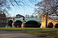
 / 52.93848; -1.13632 (Trent Bridge)
TrentBridge2022.jpg
1868–71The bridge was designed by Marriott Ogle Tarbotton, and carries London Road (A60 road) over the River Trent. It consists of three segmental cast iron arches, each span with pierced spandrels, a dentilled sill, and a pierced iron balustrade. In the centre of each span is a lamp standard. The piers are in Aberdeen granite, with pointed cutwaters. At each end is a pair of pylons with coats of arms and moulded square caps. At the southeast end are three round flood arches with moulded soffits. The approach walls are curved and have moulded string courses and copings. [13] [14] II
Friary United Reformed Church and Sunday School
52°56′03″N1°08′00″W / 52.93430°N 1.13339°W / 52.93430; -1.13339 (Friary United Reformed Church and Sunday School)
Friary United Reformed Church, West Bridgford.jpg
1897–98The church is in stone and brick with tile roofs. It consists of a nave with a clerestory, north and south aisles, a chancel, a vestry, and a northeast tower. The tower has a single stage, a string course, four pairs of corner buttresses, and a central buttress on each side, the corner buttresses rising to form pinnacles. On the east side are double doors, above are casement windows and at the top is a moulded and shaped embattled parapet. [15] [16] II
Boundary wall and gate,
St Giles Church, West Bridgford
52°55′54″N1°07′43″W / 52.93163°N 1.12852°W / 52.93163; -1.12852 (Boundary wall and gate, St Giles Church, West Bridgford)
1898The entrance to the churchyard is flanked by a pair of square stone gate piers with stepped gabled tops. Between them are a pair of wrought iron gates with curved tops, and an ornate overthrow with brackets and a lamp. The churchyard is enclosed by a stone wall with half-round coping, and it extends for about 45 metres (148 ft). [17] II
Lady Bay Junior School
52°56′18″N1°07′16″W / 52.93827°N 1.12122°W / 52.93827; -1.12122 (Lady Bay Junior School)
Lady Bay Primary School and the Number 11 bus - geograph.org.uk - 2506481.jpg
1899The school is in Accrington and blue brick, on a chamfered plinth, with a sill band, and a roof of Westmorland slate with shouldered coped gables. It is in one and two storeys, with fronts of three and six bays, and it consists of two parallel classroom ranges and service buildings. The windows are a mix of sashes and casements. On the corner is a bell tower with two stages, corner buttresses, four domed turrets, and an octagonal spire surmounted by a cupola with a leaded pagoda roof and a large dragon wind vane. In the ground floor is a doorway with a mullioned fanlight and a segmental pediment. [4] [18] II
Boundary wall, railing and gate,
Lady Bay Junior School
52°56′18″N1°07′17″W / 52.93843°N 1.12135°W / 52.93843; -1.12135 (Boundary wall, railing and gate, Lady Bay Junior School)
1899The wall is in stone with chamfered coping, and it extends for about 50 metres (160 ft). It contains five square piers with chamfered plinths and square domed caps. On the wall is scrolled railing with struts, and there are two pairs of wrought iron gates. [19] II
Musters Road Methodist Church
52°55′59″N1°07′57″W / 52.93292°N 1.13238°W / 52.93292; -1.13238 (Musters Road Methodist Church)
West Bridgford Methodist Church - geograph.org.uk - 1747267.jpg
1899–1900The church, designed by R. C. Sutton, is in stone with roofs of lead and slate. It consists of a nave and a chancel under a single roof, north and south aisles, north and south transepts, and a southwest tower. The tower has two stages, corner buttresses, a pair of west doors with a moulded surround, casement windows, clock faces, deep modillion eaves, and a shallow swept roof with a finial and a wind vane. [15] [20] II
Boundary wall and gates,
Musters Road Methodist Church
52°55′58″N1°07′58″W / 52.93288°N 1.13269°W / 52.93288; -1.13269 (Boundary wall and gates, Musters Road Methodist Church)
1899The wall and gates were designed by R. C. Sutton. The wall is in stone with square coping and rounded arrises, and it extends for about 60 metres (200 ft). It contains two pairs of square stone gate piers with moulded caps, and two pairs of scrolled wrought iron gates. [21] II
Meadows Suspension Bridge
52°56′00″N1°08′21″W / 52.93328°N 1.13915°W / 52.93328; -1.13915 (Meadows Suspension Bridge)
Wilford Suspension Bridge 0354.JPG
1906A suspension bridge carrying a footpath over the River Trent. At each end is a stone pylon on a plinth containing a round-headed arch. From these, a steel lattice deck is suspended on steel cables. It is approached by ramps with steel railing over two round floor arches. The bridge also carries services. [13] [22] II
Edwalton Hall Hotel and outbuildings
52°54′39″N1°07′02″W / 52.91088°N 1.11721°W / 52.91088; -1.11721 (Edwalton Hall Hotel and outbuildings)
c. 1907A house, later a hotel, that was extended in 1958. It is in brick on a chamfered plinth, with moulded brick dressings, Ionic pilasters, dentilled eaves, pedimented gables, and roofs of tile and lead. There are two storeys and attics, and eleven bays. The windows are a mix of sashes and casements, and there are flat-roofed dormers with small pediments. In the centre of the garden front is a two-storey canted bay window flanked by gabled wings, and the ground floor windows have pediments. Other features include shaped gables and Venetian windows. [2] [23] II
West Bridgford War Memorial
52°56′09″N1°07′58″W / 52.93591°N 1.13283°W / 52.93591; -1.13283 (West Bridgford War Memorial)
West Bridgford- lunch by the war memorial (geograph 5112501).jpg
c. 1920The war memorial stands in a triangular area at a road junction, and is in stone. It has an octagonal plinth, a base with a moulded top edge and foliate bosses, a tapered shaft with wreaths, and a crocketed finial with gabled niches. There are inscriptions and bronze plaques on the bases. [24] II
Birkin Mausoleum
52°54′37″N1°08′34″W / 52.91021°N 1.14268°W / 52.91021; -1.14268 (Birkin Mausoleum)
1921The mausoleum in Wilford Hill Cemetery is to the memory of members of the Birkin family, lace manufacturers. It is in Portland stone and in the form of a small temple. On the west front are two Roman Doric fluted columns carrying an entablature with a pediment and an acroterion, and at the opening is a pair of low bronze gates. The east front has plain pilasters, and contains full-height bronze gates. [25] [26] II
Memorial Drinking Fountain
52°54′47″N1°08′28″W / 52.91298°N 1.14101°W / 52.91298; -1.14101 (Memorial Drinking Fountain)
Birkin Memorial Drinking Fountain.jpg
1926The drinking fountain is to the memory of a member of the Birkin family, lace manufacturers. It is in Portland stone, and has a rectangular plinth of two steps containing a dog bowl. There is a stepped base on which is a cenotaph with a reeded stepped gabled top, containing a corbelled drinking bowl, above which is an inscribed panel. This is flanked by curved coped walls incorporating seats. [27] II
Nottingham Municipal War Memorial
52°56′05″N1°08′25″W / 52.93466°N 1.14021°W / 52.93466; -1.14021 (Nottingham Municipal War Memorial)
Nottingham War Memorial 0370.JPG
1927The war memorial stands in the Memorial Gardens, and is in Portland stone. It consists of a tripartite arch with giant Doric columns and an inscribed frieze, above which is a parapet containing the city arms. Within the arches are three pairs of decorative wrought iron gates, and on the interior walls of the central arch are inscribed bronze plaques. The arches are flanked by curved colonnades with intermediate pedestals and contain wrought iron railings. [28] [29] II
Terrace Wall, Memorial Gardens
52°56′05″N1°08′25″W / 52.93466°N 1.14041°W / 52.93466; -1.14041 (Terrace Wall, Memorial Gardens)
Nottingham War Memorial 0399.JPG
c. 1927The retaining terrace wall on the east side of the Nottingham Municipal War Memorial is in stone, with a balustrade and dressings in reconstituted stone, and it is about 100 metres (330 ft) long. On the top is a balustrade with intermediate piers, the centre projecting and containing three segmental arches forming shelters. [30] II
Lutterell Hall
52°55′54″N1°07′40″W / 52.93156°N 1.12785°W / 52.93156; -1.12785 (West Lutterell Hall)
West Bridgford Community Hall and Bridgford Road - geograph.org.uk - 2943121.jpg
1929A parish hall designed by Alfred John Thraves in Arts and Crafts style. It is in red brick with dressings in plum and red brick and tile-creasing, and a tile roof that sweeps down to ground floor level and is half-hipped at the gable ends. There is a single storey and attics, and a rectangular plan with an east front of seven bays. On the north front is a large semicircular arch containing a doorway with three orders of brick, the tympanum containing metalwork with a figure in relief, and an inscribed frieze. To the right is a single-storey classroom with sprocketed eaves and a hipped roof. The bays on the east front are divided by pilasters, and each contains a segmental-arched window. In the roof are five dormers, and on the ridge is a spire with copper tiles. [6] [31] II
Memorial Lychgate
52°54′34″N1°06′41″W / 52.90952°N 1.11146°W
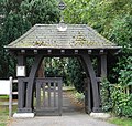
 / 52.90952; -1.11146 (Memorial Lychgate)
Church of the Holy Rood, Edwalton - Lychgate - geograph.org.uk - 912541.jpg
1932The lych gate is in timber on a chamfered stone plinth and has a shingled hipped roof. On the roof is a Celtic cross finial, and the lintel carries an inscription. [32] II
Test Match Hotel
52°55′44″N1°07′31″W / 52.92892°N 1.12534°W / 52.92892; -1.12534 (Test Match Hotel)
Test Match - geograph.org.uk - 898126.jpg
1938The public house is in buff brick on a red brick plinth and has a hipped tile roof. There are two storeys and attics, and a front of seven bays, the middle three bays projecting. In the centre is a stone portico with paired columns. Most of the windows are sashes with splayed red brick lintels, those in the middle three bays with segmental heads, curved sills and red brick surrounds, and in the attic there are round-headed dormers. The internal Art Deco furnishings have been retained. [11] [33] II*

Related Research Articles

Ilkeston is a town and unparished area in the Borough of Erewash in Derbyshire, England. The town and surrounding area contain 29 listed buildings that are recorded in the National Heritage List for England. Of these, one is listed at Grade I, the highest of the three grades, three are at Grade II*, the middle grade, and the others are at Grade II, the lowest grade. The Erewash Canal passes through the area, and the listed buildings associated with it are two bridges and two locks. The other listed buildings include churches and a chapel, a church tower, houses, a museum, the town hall, two factories, a drinking fountain, a brick kiln, a library, cemetery buildings, two cinemas, a school, a railway viaduct, and two war memorials.

Sutton-in-Ashfield is a market town in the Ashfield district of Nottinghamshire, England. The town and its surrounding area contain 13 listed buildings that are recorded in the National Heritage List for England. Of these, one is listed at Grade II*, the middle of the three grades, and the others are at Grade II, the lowest grade. The listed buildings consist of two churches, a headstone in a churchyard, houses, a public house, a former cotton mill and associated structures, and three war memorials.

Worksop is a market town in the Bassetlaw District of Nottinghamshire, England. The town contains over 100 listed buildings that are recorded in the National Heritage List for England. Of these, four are listed at Grade I, the highest of the three grades, five are at Grade II*, the middle grade, and the others are at Grade II, the lowest grade. The most important listed buildings are a former priory, later a parish church, the gatehouse to the priory, a lodge, and a country house, which are listed at Grade I, and structures associated with them are also listed. Most of the other listed buildings include houses, cottages and associated structures, shops, offices, farmhouses and farm buildings, public houses and hotels, public buildings and churches. The rest of the listed buildings include a market cross, a canal lock, schools, a bank, a railway station and a signal box, a pumping station, war memorials and a telephone kiosk.

Clumber and Hardwick is a civil parish in the Bassetlaw District of Nottinghamshire, England. The parish contains 26 listed buildings that are recorded in the National Heritage List for England. Of these, one is listed at Grade I, the highest of the three grades, six are at Grade II*, the middle grade, and the others are at Grade II, the lowest grade. The parish contains Clumber Park, the grounds of the former Clumber Park House, and the settlement of Hardwick Village. The listed buildings in Clumber Park include the surviving range of the house, the stable range, a stable courtyard and former vicarage, the kitchen gardens and a palm house, a church, a bridge, two temples, a grotto, gateways and lodges. In the village are houses, farm buildings and a war memorial.

Cropwell Bishop is a civil parish in the Rushcliffe district of Nottinghamshire, England. The parish contains twelve listed buildings that are recorded in the National Heritage List for England. Of these, one is listed at Grade I, the highest of the three grades, and the others are at Grade II, the lowest grade. The parish contains the village of Cropwell Bishop and the surrounding area. All the listed buildings are in the village, and consist of a church, the churchyard wall and headstones in the churchyard, houses and cottages, a public house and a chapel.

Dunham-on-Trent is a civil parish in the Bassetlaw District of Nottinghamshire, England. The parish contains eleven listed buildings that are recorded in the National Heritage List for England. Of these, one is listed at Grade I, the highest of the three grades, and the others are at Grade II, the lowest grade. The parish contains the village of Dunham-on-Trent and the surrounding area. The listed buildings consist of houses and cottages, farmhouses and farm buildings, a church and items in the churchyard, a public house and a war memorial.

East Bridgford is a civil parish in the Rushcliffe district of Nottinghamshire, England. The parish contains 20 listed buildings that are recorded in the National Heritage List for England. Of these, one is listed at Grade I, the highest of the three grades, and the others are at Grade II, the lowest grade. The parish contains the village of East Bridgford and the surrounding area. The listed buildings consist of houses and associated structures, farmhouses and farm buildings, a church and headstones in the churchyard, a former windmill, and a war memorial.

Granby is a civil parish in the Rushcliffe district of Nottinghamshire, England. The parish contains 13 listed buildings that are recorded in the National Heritage List for England. Of these, one is listed at Grade I, the highest of the three grades, and the others are at Grade II, the lowest grade. The parish contains the villages of Granby and Sutton, and the surrounding countryside. The listed buildings consist of a church, gravestones in the churchyard, farmhouses, a village pump, a war memorial and a telephone kiosk.

Kirton is a civil parish in the Newark and Sherwood district of Nottinghamshire, England. The parish contains four listed buildings that are recorded in the National Heritage List for England. Of these, one is listed at Grade II*, the middle of the three grades, and the others are at Grade II, the lowest grade. The parish contains the village of Kirton and the surrounding area, and the listed buildings consist of a church, its lych gate and boundary wall, and two farmhouses.

Kneeton is a civil parish in the Rushcliffe district of Nottinghamshire, England. The parish contains ten listed buildings that are recorded in the National Heritage List for England. All the listed buildings are designated at Grade II, the lowest of the three grades, which is applied to "buildings of national importance and special interest". The parish contains the village of Kneeton and the surrounding area. All the listed buildings are in the village, and consist of a church, headstones in the churchyard, houses, cottages and associated structures, farmhouses and farm buildings.

Langar cum Barnstone is a civil parish in the Rushcliffe district of Nottinghamshire, England. The parish contains 24 listed buildings that are recorded in the National Heritage List for England. Of these, one is listed at Grade I, the highest of the three grades, one is at Grade II*, the middle grade, and the others are at Grade II, the lowest grade. The parish contains the villages of Langar and Barnstone and the surrounding countryside. All the listed buildings are in the villages, and consist of a church, tombs and headstones in the churchyard, the churchyard wall, houses, cottages and associated structures, farmhouses and farm buildings, a public house, a former school, a war memorial and a telephone kiosk.

Mansfield is a town in the Mansfield District of Nottinghamshire, England. The town and its surrounding area contain over 200 listed buildings that are recorded in the National Heritage List for England. Of these, one is listed at Grade I, the highest of the three grades, nine at Grade II*, the middle grade, and the others are at Grade II, the lowest grade. Mansfield was a royal manor in the 11th and 12th centuries, and since the Middle Ages it has been the main market centre for west Nottinghamshire. During the Industrial Revolution, mills were built long the River Maun, and the town also became a centre for stocking frame knitting, but few buildings from this period have survived.

Ollerton and Boughton is a civil parish in the Newark and Sherwood district of Nottinghamshire, England. The parish contains 22 listed buildings that are recorded in the National Heritage List for England. Of these, one is listed at Grade II*, the middle of the three grades, and the others are at Grade II, the lowest grade. The parish contains the town of Ollerton, the villages of New Ollerton and Boughton, and the surrounding countryside. In the parish is Boughton Pumping Station, and three buildings associated with it are listed. The other listed buildings include houses, cottages and associated structures, three churches and associated structures, a church hall, a hotel and a public house, a former watermill, a bridge, a war memorial and a public house.


Ossington is a civil parish in the Newark and Sherwood district of Nottinghamshire, England. The parish contains ten listed buildings that are recorded in the National Heritage List for England. Of these, one is listed at Grade I, the highest of the three grades, one is at Grade II*, the middle grade, and the others are at Grade II, the lowest grade. The parish contains the village of Ossington and the surrounding countryside. One of the most important buildings in the parish was Ossington Hall, but this was demolished in 1963. There are two surviving buildings associated with the hall that are listed, namely a memorial well head, and the gates and walls at the entrance to the grounds. The only building listed at Grade I is Holy Rood Church, and its gateway and a sundial in the churchyard are also listed. The other listed buildings consist of houses, farmhouses and farm buildings, and a war memorial.

Owthorpe is a civil parish in the Rushcliffe district of Nottinghamshire, England. The parish contains eight listed buildings that are recorded in the National Heritage List for England. Of these, one is listed at Grade II*, the middle of the three grades, and the others are at Grade II, the lowest grade. The parish contains the village of Owthorpe and the surrounding countryside, and the listed buildings consist of a church, headstones in the churchyard, three mile markers on the Grantham Canal, a farmhouse and a pair of cottages.

Upper Broughton is a civil parish in the Rushcliffe district of Nottinghamshire, England. The parish contains 17 listed buildings that are recorded in the National Heritage List for England. Of these, one is listed at Grade I, the highest of the three grades, and the others are at Grade II, the lowest grade. The parish contains the village of Upper Broughton and the surrounding countryside. Most of the listed buildings are houses, cottages, farmhouses and associated structures. The others include a church, headstones and a war memorial in the churchyard, the churchyard wall and gates, a village cross, and a former chapel.

Warsop is a civil parish in the Mansfield District of Nottinghamshire, England. The parish contains 28 listed buildings that are recorded in the National Heritage List for England. Of these, two are listed at Grade I, the highest of the three grades, one is at Grade II*, the middle grade, and the others are at Grade II, the lowest grade. The parish contains the town of Warsop, the settlements of Church Warsop and Sookholme, and the surrounding countryside. Most of the listed buildings are houses, cottages and associated structures, farmhouses and farm buildings. The other listed buildings include two churches with associated structures, a parish centre converted from an old courtyard house, a public house, a bridge and a weir, a watermill, a windmill, and a war memorial.

West Markham is a civil parish in the Bassetlaw District of Nottinghamshire, England. The parish contains four listed buildings that are recorded in the National Heritage List for England. Of these, two are listed at Grade I, the highest of the three grades, and the others are at Grade II, the lowest grade. The parish contains the village of West Markham and the surrounding area. The listed buildings consist of a church and headstones in its churchyard, and a mausoleum and its surrounding walls and railings.

Whatton-in-the-Vale is a civil parish in the Rushcliffe district of Nottinghamshire, England. The parish contains seven listed buildings that are recorded in the National Heritage List for England. Of these, one is listed at Grade II*, the middle of the three grades, and the others are at Grade II, the lowest grade. The parish contains the village of Whatton-in-the-Vale and the countryside to the south. The listed buildings consist of a church, a group of headstones in the churchyard and its boundary wall, a house, a road bridge, a windmill and a stable block.

Hyson Green and Arboretum is an electoral ward in the city of Nottingham, England. The ward contains over 60 listed buildings that are recorded in the National Heritage List for England. Of these, two are listed at Grade II*, the middle of the three grades, and the others are at Grade II, the lowest grade. The ward is to the north of the centre of the city, and includes the areas of Hyson Green and Arboretum. In the ward are buildings forming part of Nottingham Trent University, some of which are listed. The ward contains the open areas of Nottingham General Cemetery, the Forest Recreation Ground, The Arboretum and Church Cemetery, all of which contain listed buildings. In the past, the area was involved with the lace making industry, and in the ward are former workshops and factories that have been converted for other uses and are listed. The other listed buildings include houses, offices, shops, warehouses, war memorials, churches and associated structures, Nottingham High School, and a theatre.

References

Citations

Sources