Old River Lea

Last updated

Old River Lea
Old River Lea - geograph.org.uk - 968903.jpg
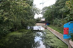
Looking north east from its junction with the Navigation just below Old Ford Locks
Location
Country United Kingdom
Physical characteristics
Source 
  location Lea Bridge
Mouth  
  location
River Lee Navigation and Bow Back Rivers
  elevation
0 m (0 ft)
Length3.2 km (2.0 mi)

The Old River Lea is the former natural channel of the River Lea below Lea Bridge, in the London Borough of Hackney. The Old River forms a large meander from the Middlesex Filter Beds Weir to rejoin the main channel of the River Lee Navigation below Old Ford Lock, just west of the 2012 Olympic stadium.

Contents

The natural channel is joined by the River Lee Flood Relief Channel, and Dagenham Brook and a number of subsidiary channels to form the semi-tidal Bow Back Rivers, discharging into Bow Creek.

The natural channel forms the boundary between the London Boroughs of Hackney and Waltham Forest; and forms the eastern boundary of Hackney Marshes, and historically the western boundary of Leyton Marshes.

See also

Notes

    Coordinates: 51°32′17″N0°1′11″W / 51.53806°N 0.01972°W / 51.53806; -0.01972


    Related Research Articles

    London Borough of Hackney Borough in United Kingdom

    The London Borough of Hackney is a London borough in Inner London. The historical and administrative heart of Hackney is Mare Street, which lies 5 miles (8 km) north-east of Charing Cross. The borough is named after Hackney, its principal district. Southern and eastern parts of the borough are popularly regarded as being part of east London, with the northwest belonging to north London.

    River Lea River in the south east of England

    The River Lea, also spelled Lee, is a river in South East England. It originates in the Bedfordshire part of the Chiltern Hills, and flows southeast through Hertfordshire and then Greater London, sometimes through several channels, to ultimately meet the River Thames, the last looping section being known as Bow Creek. It is one of the largest rivers in London and the easternmost major tributary of the Thames.

    Hertford Union Canal

    The Hertford Union Canal or Duckett's Cut is just over 1 mile (1.6 km) long in the London Borough of Tower Hamlets in East London. It connects the Regent's Canal to the Lee Navigation. It was opened in 1830 but quickly proved to be a commercial failure. It was acquired by the Regents Canal Company in 1857, and became part of the Grand Union Canal in 1927.

    Lee Navigation Canalised river in Hertfordshire and London, England

    The Lee Navigation is a canalised river incorporating the River Lea. It flows from Hertford Castle Weir to the River Thames at Bow Creek; its first lock is Hertford Lock and its last Bow Locks.

    Lea Bridge Human settlement in England

    Lea Bridge is a district in the London Borough of Hackney and the London Borough of Waltham Forest in London, England. It lies 7 miles northeast of Charing Cross.

    Hackney Marshes Human settlement in England

    Hackney Marshes is an area of open space in London's Lower Lea Valley, lying on the western bank of the River Lea. It takes its name from its position on the eastern boundary of Hackney, the principal part of the London Borough of Hackney, and from its origin as an area of true marsh.

    Bow Creek (London)

    Bow Creek is a 2.25-mile (3.6 km) long tidal estuary of the English River Lea and is part of the Bow Back Rivers. Below Bow Locks the creek forms the boundary between the London Boroughs of Newham and Tower Hamlets, in East London.

    Lower Lea Valley

    The Lower Lea Valley is the southern end of the Lea Valley which surrounds the River Lea. It is part of the Thames Gateway redevelopment area and was the location of the 2012 Summer Olympics.

    East London Northeastern part of London, United Kingdom

    East London is a popularly and informally defined part of London, capital of the United Kingdom. By most definitions, it is east of the ancient City of London and north of the River Thames. It broadly comprises the London boroughs of Barking and Dagenham, Hackney, Havering, Newham, Redbridge, Tower Hamlets and Waltham Forest. This understanding accords closely, but not exactly, with the interpretation of the area consisting of the former Tower Division, and London east of the Lea. The East End of London is a subset of East London, consisting of areas close to the ancient City of London. The Eastern (E) Postal District is a different subset of East London; and there is also an "East" sub-region used in the London Plan for planning policy reporting purposes. The most recent (2011) iteration includes seven boroughs north of the Thames, with the addition of three boroughs south of the river.

    Lee Valley Park

    Lee Valley Regional Park is a 10,000-acre (40 km2) 26 miles (42 km) long linear park, much of it green spaces, running through the northeast of Greater London, Essex and Hertfordshire from the River Thames to Ware, through areas such as Stratford, Clapton, Tottenham, Enfield, Walthamstow, Cheshunt, Broxbourne and Hoddesdon in an area generally known as the Lea Valley. Greater London's largest park, Lee Valley Park is more than four times the size of Richmond Park, extending beyond Greater London's borders into the neighbouring counties of Hertfordshire and Essex.

    Walthamstow Marshes

    Walthamstow Marshes, is a 36.7 hectare biological Site of Special Scientific Interest in Walthamstow in the London Borough of Waltham Forest. It was once an area of lammas land – common land used for growing crops and grazing cattle.

    The Lea Valley, the valley of the River Lea, has been used as a transport corridor, a source of sand and gravel, an industrial area, a water supply for London, and a recreational area. The London 2012 Summer Olympics were based in Stratford, in the Lower Lea Valley. It is very important for London's water supply, as the source of the water transported by the New River aqueduct, but also as the location for the Lee Valley Reservoir Chain, stretching from Enfield through Tottenham and Walthamstow.

    Lea Bridge Road

    Lea Bridge Road is a major through route in east London, across the Lea Valley from Clapton to Whipps Cross in Leyton. It forms part of the A104 road.

    Lea Valley Walk Long-distance footpath in South East England

    The Lea Valley Walk is a 50-mile (80 km) long-distance path located between Leagrave, the source of the River Lea near Luton, and the Thames, at Limehouse Basin, Limehouse, east London. From its source much of the walk is rural. At Hertford the path follows the towpath of the River Lee Navigation, and it becomes increasingly urbanised as it approaches London. The walk was opened in 1993 and is waymarked throughout using a swan logo.

    Small River Lea

    The Small River Lea is a minor tributary of the River Lea, which flows through the Lee Valley Park between Cheshunt and Enfield Lock. It forms part of the Turnford and Cheshunt Pits Site of Special Scientific Interest (SSSI) as it flows through the River Lee Country Park.

    Lee Flood Relief Channel

    The Lee Flood Relief Channel (FRC) is located in the Lea Valley and flows between Ware, Hertfordshire, and Stratford, east London. Work started on the channel in 1947 following major flooding and it was fully operational by 1976. The channel incorporates existing watercourses, lakes, and new channels. Water from the channel feeds the Lee Valley Reservoir Chain.

    Old Ford Lock Lock on the River Lee Navigation, London, England

    Old Ford Lock is a paired lock and weir on the River Lee Navigation, in the London Borough of Tower Hamlets, England. It is at Fish Island in Old Ford and takes it namesake from after the natural ford which used to exist in the area crossing the uncanalised River Lea.

    Middlesex Filter Beds Weir Weir on the River Lea in London, England

    The Middlesex Filter Beds Weir, or Lea Bridge Road Weir, marks the start of the Hackney Cut, an artificial channel of the River Lee Navigation built in 1770, in the London Borough of Hackney. The weir lies between the former Middlesex Filter Beds – now a nature reserve – and the Thames Water treatment works at Lea Bridge Road.

    Hackney Cut

    The Hackney Cut is an artificial channel of the Lee Navigation built in England in 1769 by the River Lea Trustees to straighten and improve the Navigation. It begins at the Middlesex Filter Beds Weir, below Lea Bridge, and is situated in the (modern) London Borough of Hackney. When built it contained two pound locks and a half-lock, but was rebuilt to handle larger barges in the 1850s, and now only Old Ford Lock, which is actually a duplicated pair, remains.

    Springfield Park (London)

    Springfield Park is a park in Upper Clapton in the London Borough of Hackney.