Hackney Cut

Last updated

Hackney Cut
Middlesex Filter Beds Weir-Head.jpg
The natural flow continues over the head of the Middlesex Filter Beds Weir, Hackney Cut continues the navigation to the right. The island between contains a nature reserve in the former filter beds.
Specifications
Locks1 pair
StatusOpen
Navigation authorityCanal and River Trust
History
Date of act1767
Date of first use1769
Geography
Start point Lea Bridge
End point Old Ford
Connects to(part of) Lee Navigation

The Hackney Cut is an artificial channel of the Lee Navigation built in England in 1769 by the River Lea Trustees to straighten and improve the Navigation. It begins at the Middlesex Filter Beds Weir, below Lea Bridge, and is situated in the (modern) London Borough of Hackney. When built it contained two pound locks and a half-lock, but was rebuilt to handle larger barges in the 1850s, and now only Old Ford Lock, which is actually a duplicated pair, remains.

Contents

History

The River Lea (or Lee) has a long history of use for navigation, with records indicating that the Abbot of Waltham was authorised to make improvements in 1190, [1] and evidence for tidal gates at Bow from the reign of King Edward I, when Henry de Bedyk, the prior at Halliwell Priory and owner of the nearby tide mills, erected a structure some time before 1307. [2] River levels were managed by flash locks or sluices, and as the volumes of traffic using the river increased, there was friction between the bargees and the millers, since use of a flash lock affected the head of water available at the adjacent mill. In 1765, the commissioners responsible for the river asked the engineer John Smeaton to survey the river and make recommendations for its improvement. [3]

Smeaton produced his report in September 1766, in which he recommended that the flash locks should be replaced by pound locks with two sets of gates, and that a number of new cuts should be built, including what became known as the Hackney Cut from Lea Bridge to Old Ford. [4] The commissioners advertised in the London Gazette and other newspapers that they wanted to borrow £35,000 to finance the improvements, to which there was a huge response. Some £161,500 was offered, and subscribers had to be picked by a ballot. Work on the whole scheme progressed quickly, and the contract for the Hackney Cut was awarded to Jeremiah Ilsley on 18 January 1768. He was probably acting as a public works contractor, since he also had contracts for the Waltham Cut and part of the Limehouse Cut, and so must have been managing a large labour force. He was to be paid 3 old pence (3d, 1.25p) per yard for the Hackney Cut, considerably less than the rate for the Limehouse Cut, which was 7d, and was given four months in which to complete the excavations. [5]

Contracts for the construction of the locks were separate to the excavation, and the work on the two locks of the Hackney Cut was given to Henry Holland, a bricklayer from Piccadilly, on 23 April 1768. Despite tight schedules, the work seems to have been completed on time, and the Hackney Cut opened for traffic on 7 August 1769. [6] At the northern end of the cut, the river flowed to the east, through a weir now known as Middlesex Filter Beds Weir. Beside it was Hackney Waterworks Lock, the third pound lock to be built on the Navigation in 1762. It was tidal, as the course of the Old River Lee was affected by tides from the Thames up to this point. The new cut was protected by Lea Bridge Half Lock, a single set of gates just below the junction. [7] Homerton Lock, which was also known as Hackney Brick Cistern Lock, was about one-third of the way along the cut, [8] while Old Ford Lock was located just above where the cut rejoined the old course of the river. The lock was semi-tidal, as the level on this section of the river was maintained by Bow tidal gates, but spring tides often flowed over the top of the gates and the locks which supplemented them after 1850, continuing to do so until the installation of extra flood walls and higher flood gates in 2000. [9]

Development

An Act of Parliament obtained in 1850 paved the way for a major upgrade of the navigation. Among other things, it removed the restriction on the maximum load that could be carried by barges. This had been set at 40 tons in 1805, but with the clause removed, the navigation between the Thames and Tottenham was gradually rebuilt to take 100-ton barges. [10]

Lea Bridge Lock remained in operation until 1853, when it was demolished. It was replaced by Pond Lane Lock, which was built in 1865 at Cow Bridge, about halfway between Lea Bridge and Homerton Lock. Seven years later, the navigation was rebuilt so that it was level from Tottenham to Old Ford, and the lock was then redundant, but was retained to help protect the navigation below it in times of flood. It was removed in 1931, when it was superseded by a new structure with vertical guillotine gates, located a little further upstream. [11] These became redundant with the construction of the Thames Barrier, and the gates were removed in 1987. [12] Homerton lock was removed in the 1860s, following dredging of the river down to Old Ford. [13]

Old Ford Lock was rebuilt as a pair of locks on a different alignment in 1856, and the junction with the old course of the River Lee was reworked to remove an awkward bend. They were known as the small lock and the large lock, one being 15.75 feet (4.80 m) wide and the other being 18.25 feet (5.56 m) wide. Both were rebuilt with a width of 18.5 feet (5.64 m) in 1935, but retained their names, the small lock being shallower than the large lock. Further rebuilding had to take place during the Second World War after they were hit by a bomb on 19 October 1940, which also destroyed the lock houses. New lock houses were built in 1946, and were sold in the 1990s, after which they were used as the location for the television programme "The Big Breakfast". [14]

From 1829, water was abstracted at Lea Bridge, from the natural watercourse, by the East London Waterworks Company, to avoid the increasing pollution of the Navigation. The waterworks was located to the south of Old Ford Locks, and the company built a canal in 1830 which ran along the east bank of the Hackney Cut to transfer water from Lea Bridge for processing. [15] William Hoof, who had gained a reputation as a specialist tunnelling contractor, after working on Strood Tunnel for the Thames and Medway Canal and Harecastle Tunnel on the Trent and Mersey Canal, worked on the waterworks project from 1829 until 1834. [16]

In 1824, George Duckett, the son of Sir George Duckett, 1st Baronet who had owned the Stort Navigation, obtained an Act of Parliament to link the Hackney Cut to the Regents Canal, which he hoped would result in much of the trade which passed onto the Thames from the Lee Navigation being re-routed to Regents Canal Dock. The Hertford Union Canal, which was 1.25 miles (2.0 km) long, included three locks, and joined the cut a short distance above Old Ford Locks, opened in 1830 but failed to attract much traffic, due to the level of tolls. [17]

Route

The Hackney Cut is 2 miles (3.2 km) long from Lea Bridge road bridge to Old Ford Locks. [18] Excess water from the Navigation passes over the weir into the former natural channel of the River Lea that passes in a large meander to the east of the modern water course, forming the boundary with the London Borough of Waltham Forest. The old course used to rejoin the Navigation below Old Ford Lock, but this route was modified by the construction of Carpenter's Road Lock on the Bow Back Rivers in 1930. Prescott Channel was built at the same time to provide a bypass around the tide mill at Three Mills, allowing the water to reach Bow Creek and the River Thames. [19] A lock was built in the Prescott Channel in 2009.

Related Research Articles

<span class="mw-page-title-main">Chelmer and Blackwater Navigation</span>

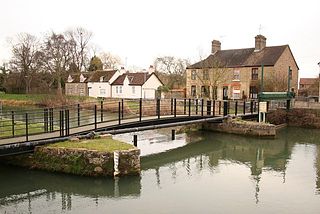
The Chelmer and Blackwater Navigation is the canalisation of the Rivers Chelmer and Blackwater in Essex, in the east of England. The navigation runs for 13.75 miles (22.13 km) from Springfield Basin in Chelmsford to the sea lock at Heybridge Basin near Maldon. Initial plans faced spirited opposition from Maldon, which were overcome by avoiding the town and terminating at Heybridge, and the navigation opened in 1797. There were some teething problems, and the engineer John Rennie was called back on two occasions to recommend improvements. The impact of the railways was less severe than on many canals, as there was never a direct line between Chelmsford and Maldon. The sea lock at Heybridge was enlarged after the Second World War, but trade gradually declined and ceased in 1972.

<span class="mw-page-title-main">River Lea</span> River in the south east of England

The River Lea is in South East England. It originates in Bedfordshire, in the Chiltern Hills, and flows southeast through Hertfordshire, along the Essex border and into Greater London, to meet the River Thames at Bow Creek. It is one of the largest rivers in London and the easternmost major tributary of the Thames.

<span class="mw-page-title-main">Limehouse Cut</span> Canal in East End of London, England

The Limehouse Cut is a largely straight, broad canal in the East End of London which links the lower reaches of the Lee Navigation to the River Thames. Opening on 17 September 1770, and widened for two-way traffic by 1777, it is the oldest canal in the London area. Although short, it has a diverse social and industrial history. Formerly discharging directly into the Thames, since 1968 it has done so indirectly by a connection through Limehouse Basin.

<span class="mw-page-title-main">Hertford Union Canal</span> Canal in the London Borough of Tower Hamlets

The Hertford Union Canal or Duckett's Cut, just over 1 mile (1.6 km) long, connects the Regent's Canal to the Lee Navigation in the London Borough of Tower Hamlets in East London. It was opened in 1830 but quickly proved to be a commercial failure. It was acquired by the Regents Canal Company in 1857, and became part of the Grand Union Canal in 1927.

<span class="mw-page-title-main">Lee Navigation</span> Canalised river in Hertfordshire and London, England

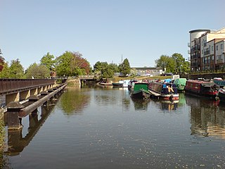
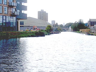
The Lee Navigation is a canalised river incorporating the River Lea. It flows from Hertford Castle Weir to the River Thames at Bow Creek; its first lock is Hertford Lock and its last Bow Locks.

<span class="mw-page-title-main">Bow Creek (London)</span> River in England

Bow Creek is a 2.25-mile (3.6 km) long tidal estuary of the English River Lea and is part of the Bow Back Rivers. Below Bow Locks the creek forms the boundary between the London Boroughs of Newham and Tower Hamlets, in East London.

<span class="mw-page-title-main">Bow Back Rivers</span> Waterways in east London

Bow Back Rivers or Stratford Back Rivers is a complex of waterways between Bow and Stratford in east London, England, which connect the River Lea to the River Thames. Starting in the twelfth century, works were carried out to drain Stratford Marshes and several of the waterways were constructed to power watermills. Bow Creek provided the final outfall to the Thames, and the other channels were called Abbey Creek, Channelsea River, City Mill River, Prescott Channel, Pudding Mill River, Saint Thomas Creek, Three Mills Back River, Three Mills Wall River and Waterworks River.

<span class="mw-page-title-main">Stort Navigation</span>

The Stort Navigation is the canalised section of the River Stort running 22 kilometres (14 mi) from the town of Bishop's Stortford, Hertfordshire, downstream to its confluence with the Lee Navigation at Feildes Weir near Rye House, Hoddesdon, Hertfordshire.

<span class="mw-page-title-main">City Mill River</span> Canal in East London

City Mill River is part of the Bow Back Rivers in London, England. It formerly fed City Mill, used for the production of chemicals in the late nineteenth and early twentieth centuries. In the 1930s, the mill was removed and the river was isolated from the tides by the construction of locks at both ends. City Mill Lock, at the southern end, has been refurbished and reopened in 2010.

<span class="mw-page-title-main">Old Ford</span> Human settlement in England

Old Ford is an area in the London Borough of Tower Hamlets that is named after the natural ford which provided a crossing of the River Lea.

<span class="mw-page-title-main">Stamford Canal</span> Canal in Lincolnshire, England

Stamford Canal, now disused, is one of the earliest post-Roman canals in England. It opened in 1670, around 100 years before the start of the Industrial Revolution which brought about the "golden age" for canals in Britain. Parts of the route can be traced on the ground, though only one lock survives intact. It was part of the Welland Navigation in Lincolnshire. First authorised in 1571, during the reign of Elizabeth I, construction did not start until 1664, under powers granted in 1620 and ratified by James I. It ran for 9.5 miles (15.3 km) from Stamford to Market Deeping and had 12 locks, two of which were on the river section at Deeping St James. No plans of its construction survive, although one of the locks was documented by a visiting water engineer in 1699. It contributed to the wealth of Stamford, allowing barley to be transported to the town for malting.

<span class="mw-page-title-main">Bow Locks</span> Canal lock in London

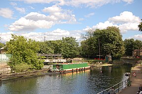
Bow Locks No. 20 is a set of bi-directional locks in Bromley-by-Bow in the London Borough of Tower Hamlets and Newham. The locks link the tidal Bow Creek to the River Lee Navigation, which is a canalised river. These locks were first built in 1850 and then rebuilt in 1930, at the same time as the Prescott Channel was cut nearby. At high tide, the tide from Bow Creek formerly flowed through Bow Locks, to raise the level of the canals, such as the Limehouse Cut. In 2000, these locks were modified to keep the tide out, to reduce silting in the canal system.

<span class="mw-page-title-main">Lea Valley Walk</span> Long-distance footpath in South East England

The Lea Valley Walk is a 50-mile (80 km) long-distance path located between Leagrave, the source of the River Lea near Luton, and the Thames, at Limehouse Basin, Limehouse, east London. From its source much of the walk is rural. At Hertford the path follows the towpath of the River Lee Navigation, and it becomes increasingly urbanised as it approaches London. The walk was opened in 1993 and is waymarked throughout using a swan logo.

<span class="mw-page-title-main">Old Ford Lock</span> Lock on the River Lee Navigation, London, England

Old Ford Lock is a paired lock and weir on the River Lee Navigation, in the London Borough of Tower Hamlets, England. It is at Fish Island in Old Ford and takes its name from the natural ford which used to cross the River Lea.

<span class="mw-page-title-main">Three Mills Lock</span> Lock on Prescott Channel

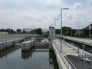
Three Mills Lock, also known as the Prescott Lock is a lock on the Prescott Channel on the River Lea in London. The project was led by British Waterways and the lock officially opened on 5 June 2009.

<span class="mw-page-title-main">Pond Lane Flood Gates</span>

Pond Lane Flood Gates is a redundant flood defence structure, located near Lea Bridge Road on the River Lee Navigation in the London Borough of Hackney, England.

<span class="mw-page-title-main">Middlesex Filter Beds Weir</span> Weir on the River Lea in London, England

The Middlesex Filter Beds Weir, or Lea Bridge Road Weir, marks the start of the Hackney Cut, an artificial channel of the River Lee Navigation built in 1770, in the London Borough of Hackney. The weir lies between the former Middlesex Filter Beds – now a nature reserve – and the Thames Water treatment works at Lea Bridge Road.

<span class="mw-page-title-main">Three Mills Wall River Weir</span> Weir on the Bow Back Rivers in London, England

Three Mills Wall River Weir is a weir on the Bow Back Rivers, in Mill Meads in the London Borough of Newham, England, near to Three Mills. It was built in 2009, when the Bow Back Rivers were refurbished to make them a key feature of the Queen Elizabeth Olympic Park, and maintains water levels through much of the park in conjunction with the Three Mills Lock and sluice on the Prescott Channel.

<span class="mw-page-title-main">Carpenter's Road Lock</span>

Carpenter's Road Lock is a rising radial lock in the London Borough of Newham, near Marshgate Lane in Stratford, England. It is located on the Bow Back Rivers and was constructed in 1933/34. It is the only lock in Britain with rising radial gates at both ends. British Waterways were hoping to restore it as part of the upgrade to Bow Back Rivers which took place for the 2012 Summer Olympics, but the gantries which enabled the gates to be raised were demolished to accommodate a wide bridge giving access to the main stadium. After the Games, most of the overbridge was removed. Funding for the restoration of the lock was in place by early 2016, and it is expected to be brought back into use in 2017.

<span class="mw-page-title-main">Old River Lea</span> River in United Kingdom

The Old River Lea is the former natural channel of the River Lea below Lea Bridge, in the London Borough of Hackney. The Old River forms a large meander from the Middlesex Filter Beds Weir to rejoin the main channel of the River Lee Navigation below Old Ford Lock, just west of the 2012 Olympic stadium.

References

  1. Boyes & Russell 1977 , p. 14
  2. Thomas 2010a
  3. Boyes & Russell 1977 , pp. 19–20
  4. Boyes & Russell 1977 , p. 20
  5. Boyes & Russell 1977 , p. 22
  6. Boyes & Russell 1977 , pp. 22–23
  7. Thomas 2010c
  8. Thomas 2010b
  9. Thomas 2010d
  10. Boyes & Russell 1977 , pp. 28, 32
  11. Thomas 2010c
  12. Pond Lane flood gates Retrieved 14 July 2008
  13. Thomas 2010b
  14. Thomas 2010d
  15. "East London Waterworks Company, Brief history during the Snow era, 1813 - 1858". UCLA Epidemiology. Retrieved 31 July 2008.
  16. Skempton 2002 , p. 334
  17. Hadfield, Charles (1966). The Canals of the East Midlands. Newton Abbot: David & Charles. pp. 134–135.
  18. Cumberlidge 2009 , p. 168
  19. Boyes & Russell 1977 , pp. 36–37

Bibliography

Coordinates: 51°33′00″N0°01′43″W / 51.5501°N 0.0287°W / 51.5501; -0.0287