
The Calder and Hebble Navigation is a broad inland waterway, with locks and bridgeholes that are suitable for 14-foot-wide (4.3 m) boats, in West Yorkshire, England. Construction to improve the River Calder and the River Hebble began in 1759, and the initial scheme, which included 5.7 miles (9.2 km) of new cuts, was completed in 1770 and has remained navigable since it was opened. Significant improvements were made, including the Salterhebble branch to Halifax, opened in 1828, and ever-longer cuts to bypass river sections. Trade was assisted by the opening of the Rochdale Canal in 1804, which provided a through route from Sowerby Bridge to Manchester. There were plans to abandon the river sections completely in the 1830s, but these were modified as the needs of mill owners and other riparian landowners were recognised.

The River Weaver is a river, navigable in its lower reaches, running in a curving route anti-clockwise across west Cheshire, northern England. Improvements to the river to make it navigable were authorised in 1720 and the work, which included eleven locks, was completed in 1732. An unusual clause in the enabling Act of Parliament stipulated that profits should be given to the County of Cheshire for the improvement of roads and bridges, but the navigation was not initially profitable, and it was 1775 before the first payments were made. Trade continued to rise, and by 1845, over £500,000 had been given to the county.
The River Lea is in the East of England and Greater London. It originates in Bedfordshire, in the Chiltern Hills, and flows southeast through Hertfordshire, along the Essex border and into Greater London, to meet the River Thames at Bow Creek. It is one of the largest rivers in London and the easternmost major tributary of the Thames.

The Limehouse Cut is a largely straight, broad canal in the East End of London which links the lower reaches of the Lee Navigation to the River Thames. Opening on 17 September 1770, and widened for two-way traffic by 1777, it is the oldest canal in the London area. Although short, it has a diverse social and industrial history. Formerly discharging directly into the Thames, since 1968 it has done so indirectly by a connection through Limehouse Basin.
The Hertford Union Canal or Duckett's Cut, just over 1 mile (1.6 km) long, connects the Regent's Canal to the Lee Navigation in the London Borough of Tower Hamlets in East London. It was opened in 1830 but quickly proved to be a commercial failure. It was acquired by the Regents Canal Company in 1857, and became part of the Grand Union Canal in 1927.

The Lee Navigation is a canalised river incorporating the River Lea. It flows from Hertford Castle Weir to the River Thames at Bow Creek; its first lock is Hertford Lock and its last Bow Locks.

Bow Creek is a 2.25-mile (3.6 km) long tidal estuary of the English River Lea and is part of the Bow Back Rivers. Below Bow Locks the creek forms the boundary between the London Boroughs of Newham and Tower Hamlets, in East London.
Bow Back Rivers or Stratford Back Rivers is a complex of waterways between Bow and Stratford in east London, England, which connect the River Lea to the River Thames. Starting in the twelfth century, works were carried out to drain Stratford Marshes and several of the waterways were constructed to power watermills. Bow Creek provided the final outfall to the Thames, and the other channels were called Abbey Creek, Channelsea River, City Mill River, Prescott Channel, Pudding Mill River, Saint Thomas Creek, Three Mills Back River, Three Mills Wall River and Waterworks River.

City Mill River is part of the Bow Back Rivers in London, England. It formerly fed City Mill, used for the production of chemicals in the late nineteenth and early twentieth centuries. In the 1930s, the mill was removed and the river was isolated from the tides by the construction of locks at both ends. City Mill Lock, at the southern end, has been refurbished and reopened in 2010.

The London Borough of Tower Hamlets, in spite of being close to the centre of London and perhaps retaining the idea of it being the docklands area, has over 100 areas of parks and open spaces within its boundaries. These range from the huge to small gardens and squares. In common with all the London boroughs, these green spaces provide "lungs" for the leisure pursuits of the inhabitants.

Bow Locks No. 20 is a set of bi-directional locks in Bromley-by-Bow in the London Borough of Tower Hamlets and Newham. The locks link the tidal Bow Creek to the River Lee Navigation, which is a canalised river. These locks were first built in 1850 and then rebuilt in 1930, at the same time as the Prescott Channel was cut nearby. At high tide, the tide from Bow Creek formerly flowed through Bow Locks, to raise the level of the canals, such as the Limehouse Cut. In 2000, these locks were modified to keep the tide out, to reduce silting in the canal system.

The Lea Valley Walk is a 50-mile (80 km) long-distance path located between Leagrave, the source of the River Lea near Luton, and the Thames, at Limehouse Basin, Limehouse, east London. From its source much of the walk is rural. At Hertford the path follows the towpath of the River Lee Navigation, and it becomes increasingly urbanised as it approaches London. The walk was opened in 1993 and is waymarked throughout using a swan logo.

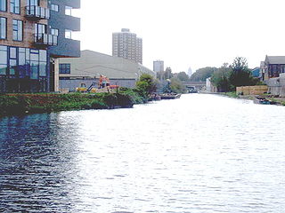
Old Ford Lock is a paired lock and weir on the River Lee Navigation, in the London Borough of Tower Hamlets, England. It is at Fish Island in Old Ford and takes its name from the natural ford which used to cross the River Lea.
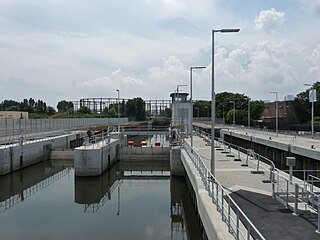
Three Mills Lock, also known as Prescott Lock, is a lock on the Prescott Channel on the River Lea in London. The current structure was constructed by British Waterways and officially opened on 5 June 2009.
Britannia Stop Lock was a lock on the Limehouse Cut in the London Borough of Tower Hamlets. It was built in 1853. The gates were either side of Commercial Road bridge and were oriented such that a boat travelling from south-west to north-east would ascend in height.

Three Mills Wall River Weir is a weir on the Bow Back Rivers, in Mill Meads in the London Borough of Newham, England, near to Three Mills. It was built in 2009, when the Bow Back Rivers were refurbished to make them a key feature of the Queen Elizabeth Olympic Park, and maintains water levels through much of the park in conjunction with the Three Mills Lock and sluice on the Prescott Channel.

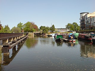
The Hackney Cut is an artificial channel of the Lee Navigation built in England in 1769 by the River Lea Trustees to straighten and improve the Navigation. It begins at the Middlesex Filter Beds Weir, below Lea Bridge, and is situated in the (modern) London Borough of Hackney. When built it contained two pound locks and a half-lock, but was rebuilt to handle larger barges in the 1850s, and now only Old Ford Lock, which is actually a duplicated pair, remains.

Carpenter's Road Lock is a rising radial lock in the London Borough of Newham, near Marshgate Lane in Stratford, England. It is located on the Bow Back Rivers and was constructed in 1933/34. It is the only lock in Britain with rising radial gates at both ends. British Waterways were hoping to restore it as part of the upgrade to Bow Back Rivers which took place for the 2012 Summer Olympics, but the gantries which enabled the gates to be raised were demolished to accommodate a wide bridge giving access to the main stadium. After the Games, most of the overbridge was removed. Funding for the restoration of the lock was in place by early 2016, and it is expected to be brought back into use in 2017.
A floating dock, floating harbour or wet dock is a dock alongside a tidal waterway which maintains a 'constant' level, despite the changing tides.

A widebeam is a canal boat built in the style of a British narrowboat but with a beam of 2.16 metres or greater.

