
A roundabout, a rotary and a traffic circle are types of circular intersection or junction in which road traffic is permitted to flow in one direction around a central island, and priority is typically given to traffic already in the junction.
Dalston is an area of East London, in the London Borough of Hackney. It is four miles northeast of Charing Cross. Dalston began as a hamlet on either side of Dalston Lane, and as the area urbanised the term also came to apply to surrounding areas including Kingsland and Shacklewell, all three of which being part of the Ancient Parish of Hackney.

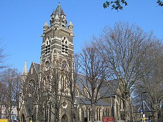
Shoreditch is an area in London, England and is located in the London Borough of Hackney alongside neighbouring parts of Tower Hamlets, which are also perceived as part of the area due to historic ecclesiastical links. Shoreditch lies just north-east of the border with the City of London and is considered to be a part of London's East End.

Old Street is a 1-mile (1.6 km) street in inner north-east Central London, England that runs west to east from Goswell Road in Clerkenwell, in the London Borough of Islington, via St Luke's and Old Street Roundabout, to the crossroads where it meets Shoreditch High Street (south), Kingsland Road (north) and Hackney Road (east) in Shoreditch in the London Borough of Hackney.

Old Street is an interchange station at the junction of Old Street and City Road in Central London for London Underground and National Rail services.
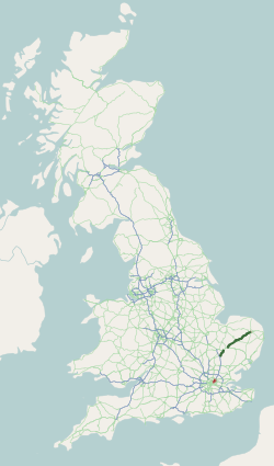
The A11 is a major trunk road in England. It originally ran roughly north east from London to Norwich, Norfolk. It now consists of a short section in Inner London and a much longer section in Cambridgeshire, Suffolk and Norfolk. The lengthy section between these was renumbered as a result of the opening of the M11 in the 1970s and then the A12 extension in 1999.

Safety in numbers is the hypothesis that, by being part of a large physical group or mass, an individual is less likely to be the victim of a mishap, accident, attack, or other bad event. Some related theories also argue that mass behaviour can reduce accident risks, such as in traffic safety – in this case, the safety effect creates an actual reduction of danger, rather than just a redistribution over a larger group.

In civil engineering, grade separation is a method of aligning a junction of two or more surface transport axes at different heights (grades) so that they will not disrupt the traffic flow on other transit routes when they cross each other. The composition of such transport axes does not have to be uniform; it can consist of a mixture of roads, footpaths, railways, canals, or airport runways. Bridges, tunnels, or a combination of both can be built at a junction to achieve the needed grade separation.

Hackney Central is a London Overground station on the North London line in the London Borough of Hackney.

The A4540 is a ring road in Birmingham, England, also known as the Middle Ring Road, or the Middleway. It runs around the centre of the city at a distance of approximately 1 mile (1.6 km). Birmingham City Centre is the area within this ring road. The ring road was planned and designed by Herbert Manzoni. It is now simply known as the Ring Road due to the removal of the old Inner Ring Road.

An advanced stop line (ASL), also called advanced stop box or bike box, is a type of road marking at signalised road junctions allowing certain types of vehicle a head start when the traffic signal changes from red to green. Advanced stop lines are implemented widely in Denmark, the United Kingdom, and other European countries.

Edinburgh is a major transport hub in east central Scotland and is at the centre of a multi-modal transport network with road, rail and air communications connecting the city with the rest of Scotland and internationally.
Transport in Cardiff, capital and most populous city in Wales involves road, rail, bus, water and air. It is a major city of the United Kingdom and a centre of employment, government, retail, business, culture, media, sport and higher education.

Cycling is a popular mode of transport and leisure activity within London, the capital city of the United Kingdom. Following a national decline in the 1960s of levels of utility cycling, cycling as a mode of everyday transport within London began a slow regrowth in the 1970s. This continued until the beginning of the 21st century, when levels began to increase significantly—during the period from 2000 to 2012, the number of daily journeys made by bicycle in Greater London doubled to 580,000. The growth in cycling can partly be attributed to the launch in 2010 by Transport for London (TfL) of a cycle hire system throughout the city's centre. By 2013, the scheme was attracting a monthly ridership of approximately 500,000, peaking at a million rides in July of that year. Health impact analyses have shown that London would benefit more from increased cycling and cycling infrastructure than other European cities.

Angel is an area on the northern fringes of Central London within the London Borough of Islington. It is 2 miles (3.2 km) north-northeast of Charing Cross on the Inner Ring Road at a busy transport intersection. The area is identified in the London Plan as one of 35 major centres in London. It is a significant commercial and retail centre, and a business improvement district. Angel straddles the ancient boundary of the parishes of Clerkenwell and Islington that later became the metropolitan boroughs of Finsbury and Islington. It is named from the former Angel Inn which stood on the corner of Islington High Street and Pentonville Road. Since 1965 the whole area has formed part of the London Borough of Islington in Greater London.

Cycling infrastructure is all infrastructure cyclists are allowed to use. Bikeways include bike paths, bike lanes, cycle tracks, rail trails and, where permitted, sidewalks. Roads used by motorists are also cycling infrastructure, except where cyclists are barred such as many freeways/motorways. It includes amenities such as bike racks for parking, shelters, service centers and specialized traffic signs and signals. The more cycling infrastructure, the more people get about by bicycle.

Bow Interchange is a busy grade-separated road junction in London, England, on the East Cross Route between Bow, Stratford, and Bromley-by-Bow at a point where the London Boroughs of Tower Hamlets and Newham meet. It is a triple-level junction where the East Cross Route, Bow Road, and Stratford High Street meet. The River Lea runs underneath the junction.

A protected intersection or protected junction, also known as a Dutch-style junction, is a type of at-grade road junction in which cyclists and pedestrians are separated from cars. The primary aim of junction protection is to help pedestrians and cyclists be and feel safer at road junctions.

There is debate over the safety implications of cycling infrastructure. Recent studies generally affirm that segregated cycle tracks have a better safety record between intersections than cycling on major roads in traffic. Furthermore, cycling infrastructure tends to lead to more people cycling. A higher modal share of people cycling is correlated with lower incidences of cyclist fatalities, leading to a "safety in numbers" effect though some contributors caution against this hypothesis. On the contrary, older studies tended to come to negative conclusions about mid-block cycle track safety.
Cycleway 4 is a fully segregated cycle path in London originally planned to run from Tower Bridge to Woolwich and coordinated by Transport for London. First proposed in 2008 but first consulted on as Cycle Superhighway 4 between Tower Bridge and Greenwich in 2017, the cycle lane has been in lengthy development. The section from Tower Bridge to Rotherhithe Roundabout, and the section on Evelyn Street and Creek Road, has been built as a permanent scheme.


