West End of London

Last updated

Piccadilly Circus, the heart of the West End, in September 2012 Open Happiness Piccadilly Circus Blue-Pink Hour 120917-1126-jikatu.jpg
Piccadilly Circus, the heart of the West End, in September 2012

The West End of London (commonly referred to as the West End) is a district of Central London, London, England, west of the City of London and north of the River Thames, in which many of the city's major tourist attractions, shops, businesses, government buildings and entertainment venues, including West End theatres, are concentrated.

Contents

The term was first used in the early 19th century to describe fashionable areas to the west of Charing Cross. [1] The West End covers parts of the boroughs of Westminster and Camden. [2]

While the City of London is the main business and financial district in London, the West End is the main commercial and entertainment centre of the city. It is the largest central business district in the United Kingdom, comparable to Midtown Manhattan in New York City, the 8th arrondissement in Paris, Causeway Bay in Hong Kong, or Shibuya in Tokyo. It is one of the most expensive locations in the world in which to rent commercial and office space.

History

Oxford Street, one of the main West End shopping areas Oxford Street (geograph 4949395).jpg
Oxford Street, one of the main West End shopping areas
Londons West End & immediate vicinity Map of the West End of London.png
Londons West End & immediate vicinity

Medieval London comprised two adjacent cities – the City of London in the east, and the City of Westminster in the west.

Dragon statue on the Temple Bar monument, which marks the boundary between the City of Westminster and City of London Temple-bar-griffin.jpg
Dragon statue on the Temple Bar monument, which marks the boundary between the City of Westminster and City of London
Aldwych Theatre in London Theatreland Aldwych Theatre 2.jpg
Aldwych Theatre in London Theatreland

Over time they came to form the centre of modern London, although each kept its own distinct character and its separate legal identity (for example, the City of London has its own police force and is a distinct county). The City of London became a centre for the banking, financial, legal and professional sectors, while Westminster became associated with the leisure, shopping, commerce, and entertainment sectors, the government, and home to universities and embassies. The modern West End is closely associated with this area of central London.

Lying to the west of the historic Roman and medieval City of London, the West End was long favoured by the rich elite as a place of residence because it was usually upwind of the smoke drifting from the crowded City. [3] It was close to the royal seat of power at the Palace of Westminster (now home to parliament), and is largely contained within the City of Westminster (one of the 32 London boroughs).

Following initial development by Henry Jermyn, 1st Earl of St Albans in the 1660s, during the late 17th, 18th and 19th centuries, it was built as a series of palaces, expensive town houses, fashionable shops and places of entertainment. The areas closest to the City around Holborn, Seven Dials, and Covent Garden contained poorer communities that were cleared and redeveloped in the 19th century.
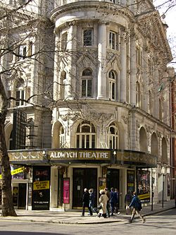
Boundaries

As the West End is a term used colloquially by Londoners and is not an official geographical or municipal definition, its exact constituent parts are up for debate. Westminster City Council's 2005 report Vision for the West End included the following areas in its definition: Covent Garden, Soho, Chinatown, Leicester Square, the shopping streets of Oxford Street, Regent Street and Bond Street, the area encompassing Trafalgar Square, the Strand and Aldwych, and the district known as Theatreland. The Edgware Road to the north-west and the Victoria Embankment to the south-east were also covered by the document but were treated as "adjacent areas" to the West End. [4]

According to Ed Glinert's West End Chronicles (2006) the districts falling within the West End are Mayfair, Soho, Covent Garden, Fitzrovia and Marylebone. [5] By this definition, the West End borders Temple, Holborn and Bloomsbury to the east, Regent's Park to the north, Paddington, Hyde Park and Knightsbridge to the west, and Victoria and Westminster to the south. Other definitions include Bloomsbury within the West End. [6]

One of the City of Westminster wards is called "West End". This electoral unit includes some of the most prosperous areas of the borough, including Soho, Mayfair and parts of southern Marylebone. [7] The population of this ward at the 2011 Census was 10,575. [8]

Notable streets

Notable squares and circuses

Marble Arch Marble.arch.london.arp.jpg
Marble Arch

The West End is laid out with many notable public squares and circuses.

Transport

London Underground stations in the West End include:

Related Research Articles

<span class="mw-page-title-main">Charing Cross Road</span> Street in central London

Charing Cross Road is a street in central London running immediately north of St Martin-in-the-Fields to St Giles Circus, which then merges into Tottenham Court Road. It leads from the north in the direction of Charing Cross at the south side of Trafalgar Square. It connects via St Martin's Place and the motorised east side of the square.

<span class="mw-page-title-main">City of Westminster</span> City and borough in London, England

The City of Westminster is a city and borough in London. It is the site of the United Kingdom's Houses of Parliament and much of the British government. It occupies a large area of central London, including most of the West End. Many London landmarks are within the borough, including Buckingham Palace, Westminster Abbey, Whitehall, Westminster Cathedral, 10 Downing Street, and Trafalgar Square.

<span class="mw-page-title-main">Holborn</span> Human settlement in England

Holborn is a district in central London, which covers the south-eastern part of the London Borough of Camden and a part of the Ward of Farringdon Without in the City of London.

<span class="mw-page-title-main">Aldwych tube station</span> London Underground station, 1907–1994

Aldwych is a closed station on the London Underground, located in the City of Westminster in Central London. It was opened in 1907 with the name Strand, after the street on which it is located. It was the terminus of the short Piccadilly line branch from Holborn that was a relic of the merger of two railway schemes. The station building is close to the Strand's junction with Surrey Street, near Aldwych. During its lifetime, the branch was the subject of a number of unrealised extension proposals that would have seen the tunnels through the station extended southwards, usually to Waterloo.

<span class="mw-page-title-main">Piccadilly</span> Road in the City of Westminster, London, England

Piccadilly is a road in the City of Westminster, London, England, to the south of Mayfair, between Hyde Park Corner in the west and Piccadilly Circus in the east. It is part of the A4 road that connects central London to Hammersmith, Earl's Court, Heathrow Airport and the M4 motorway westward. St James's is to the south of the eastern section, while the western section is built up only on the northern side. Piccadilly is just under 1 mile (1.6 km) in length, and it is one of the widest and straightest streets in central London.

<span class="mw-page-title-main">Piccadilly Circus</span> Road junction and public place in London, England

Piccadilly Circus is a road junction and public space of London's West End in the City of Westminster. It was built in 1819 to connect Regent Street with Piccadilly. In this context, a circus, from the Latin word meaning "circle", is a round open space at a street junction.

<span class="mw-page-title-main">Regent Street</span> Shopping street in London

Regent Street is a major shopping street in the West End of London. It is named after George, the Prince Regent and was laid out under the direction of the architect John Nash and James Burton. It runs from Waterloo Place in St James's at the southern end, through Piccadilly Circus and Oxford Circus, to All Souls Church. From there Langham Place and Portland Place continue the route to Regent's Park.

<span class="mw-page-title-main">Shaftesbury Avenue</span> Major street in the West End of London

Shaftesbury Avenue is a major road in the West End of London, named after The 7th Earl of Shaftesbury. It runs north-easterly from Piccadilly Circus to New Oxford Street, crossing Charing Cross Road at Cambridge Circus. From Piccadilly Circus to Cambridge Circus, it is in the City of Westminster, and from Cambridge Circus to New Oxford Street, it is in the London Borough of Camden.

<span class="mw-page-title-main">Covent Garden tube station</span> London Underground station

Covent Garden is a London Underground station serving Covent Garden and the surrounding area in the West End of London. It is on the Piccadilly line between Leicester Square and Holborn stations and is in Travelcard Zone 1. The station is at the corner of Long Acre and James Street and the street-level concourse is a Grade II listed building.

<span class="mw-page-title-main">Metropolitan Borough of Westminster</span>

The Metropolitan Borough of Westminster was a metropolitan borough in the County of London, England, from 1900 to 1965.

<span class="mw-page-title-main">St James's</span> Human settlement in England

St James's is a central district in the City of Westminster, London, forming part of the West End. The area was once part of the northwestern gardens and parks of St. James's Palace. During the Restoration in the 17th century, the area was developed as a residential location for the British aristocracy, and around the 19th century was the focus of the development of their gentlemen's clubs. Once part of the parish of St Martin in the Fields, much of it formed the parish of St James from 1685 to 1922. Since the Second World War the area has transitioned from residential to commercial use.

<span class="mw-page-title-main">Cities of London and Westminster (UK Parliament constituency)</span> UK Parliament constituency in England, created 1950

Cities of London and Westminster is a constituency returning a single Member of Parliament (MP) to the House of Commons in the United Kingdom Parliament. It is a borough constituency for the purposes of election expenses and type of returning officer. As with all constituencies, the election is decided using the first past the post system of election. Since its creation at the 1950 general election, the constituency has always elected the candidate nominated by the Conservative Party.

<span class="mw-page-title-main">A40 road in London</span> Major trunk road connecting London to Fishguard, Wales

The A40 is a major trunk road connecting London to Fishguard, Wales. The A40 in London starts in the City of London and passes through six London Boroughs: Camden, Westminster, Kensington & Chelsea, Hammersmith & Fulham, Ealing and Hillingdon, to meet the M40 motorway junction 1 at Denham, Buckinghamshire.

<span class="mw-page-title-main">Night buses in London</span> Series of night bus routes that serve Greater London

The London Night Bus network is a series of night bus routes that serve Greater London. Services broadly operate between the hours of 23:00 and 06:00.

References

  1. Mills, A., Oxford Dictionary of London Place Names, (2001)
  2. Greater London Authority, The London Plan: The Sub Regions Archived 4 June 2011 at the Wayback Machine
  3. Robert O. Bucholz and Joseph P. Ward: London: A Social and Cultural History, 1550–1750. Cambridge: Cambridge University Press 2012, p. 333
  4. Vision for the West End (PDF), Westminster City Council, October 2005, archived from the original (PDF) on 20 December 2016, retrieved 14 December 2016
  5. E. Gilnert, West End Chronicles (Penguin, 2006)
  6. Atkins, Peter J. "How the West End was won: the struggle to remove street barriers in Victorian London." Journal of Historical Geography 19.3 (1993): 265.
  7. Westminster City Council ward boundary information
  8. "City of Westminstee ward population 2011". Neighbourhood Statistics. Office for National Statistics. Retrieved 15 October 2016.

51°30′48″N0°07′43″W / 51.51333°N 0.12861°W / 51.51333; -0.12861