
The Greater London Authority (GLA), colloquially known by the metonym City Hall, is the devolved regional governance body of Greater London, England. It consists of two political branches: an executive Mayor and the 25-member London Assembly, which serves as a means of checks and balances on the Mayor. Since May 2016, both branches have been under the control of the London Labour Party. The authority was established in 2000, following a local referendum, and derives most of its powers from the Greater London Authority Act 1999 and the Greater London Authority Act 2007.

Greater Manchester is a ceremonial county in North West England. It borders Lancashire to the north, Derbyshire and West Yorkshire to the east, Cheshire to the south, and Merseyside to the west. Its largest settlement is the city of Manchester.

In the Philippines, regions are administrative divisions that primarily serve to coordinate planning and organize national government services across multiple local government units (LGUs). Most national government offices provide services through their regional branches instead of having direct provincial or city offices. Regional offices are usually but not necessarily located in the city designated as the regional center.

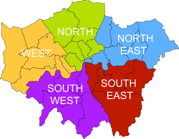
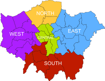
South London is the southern part of London, England, south of the River Thames. The region consists of the boroughs, in whole or in part, of Bexley, Bromley, Croydon, Greenwich, Kingston, Lambeth, Lewisham, Merton, Richmond, Southwark, Sutton and Wandsworth.

North London is the northern part of London, England, north of the River Thames. It extends from Clerkenwell and Finsbury, on the edge of the City of London financial district, to Greater London's boundary with Hertfordshire.
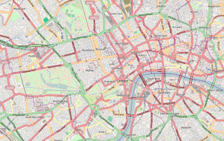
Central London is the innermost part of London, in England, spanning the City of London and several boroughs. Over time, a number of definitions have been used to define the scope of Central London for statistics, urban planning and local government. Its characteristics are understood to include a high-density built environment, high land values, an elevated daytime population and a concentration of regionally, nationally and internationally significant organisations and facilities.

The regional chambers of England were a group of indirectly elected regional bodies that were created by the provisions of the Regional Development Agencies Act 1998. There were eight regional chambers, one for each of the regions of England except Greater London, which had opted for an elected mayor and assembly in 1998. All eight regional chambers had adopted the title "regional assembly" or "assembly" as part of their name, though this was not an official status in law. The chambers were abolished over a two-year period between 31 March 2008 and 31 March 2010 and some of their functions were assumed by newly established local authority leaders' boards.
Strategic health authorities (SHA) were part of the structure of the National Health Service in England between 2002 and 2013. Each SHA was responsible for managing performance, enacting directives and implementing health policy as required by the Department of Health at a regional level. Initially 28 in number, they were reduced to 10 in 2006. Along with primary care trusts, they were replaced by clinical commissioning groups and Public Health England in 2013 under the Health and Social Care Act 2012.
City region is a term used by urbanists, economists and urban planners to refer to how one or more core cities are linked to a hinterland by functional ties, such as economic, housing-market, commuting, marketing or retail catchment factors. This concept emphasizes the importance of these functional relationships in understanding urban areas and their surrounding regions, often providing more insightful perspectives than the arbitrary boundaries assigned to administrative bodies.

The Greater Dublin Area, or simply Greater Dublin, is an informal term that is taken to include the city of Dublin and its hinterland, with varying definitions as to its extent. At the expansive end, it has been defined as including all of the traditional County Dublin and three neighbouring counties, while more commonly it is taken as the contiguous metropolitan area of Dublin plus suburban and commuter towns. The area is defined for strategic planning, and, for example, transport, and it is not a formal administrative or political unit.

The Liverpool City Region is a combined authority area in North West England. It has six council areas: the five metropolitan boroughs of Merseyside and the unitary authority of Halton in Cheshire. The region had a population of 1,571,045 in 2022.
Regional spatial strategies (RSS) provided regional level planning frameworks for the regions of England outside London. They were introduced in 2004. Their revocation was announced by the new Conservative/Liberal Democrat government on 6 July 2010.

The London Plan is the statutory spatial development strategy for the Greater London area in the United Kingdom that is written by the Mayor of London and published by the Greater London Authority. It is updated from time to time.
In England, spatial planning is undertaken at the national level, through the National Planning Policy Framework. The London region is the only one to have a statutory London Plan. Most planning functions are exercised by local authorities, with neighbourhood planning also taking place in some areas.

The regions of England, formerly known as the government office regions, are the highest tier of sub-national division in England. They were established in 1994 and follow the 1974–96 county borders. They are a continuation of the former 1940s standard regions which followed the 1889–1974 administrative county borders. Between 1994 and 2011, all nine regions had partly devolved functions; they no longer fulfil this role, continuing to be used for limited statistical purposes.

The Leeds City Region, or informally Greater Leeds, is a local enterprise partnership city region located in West Yorkshire, England. Prior to the West Yorkshire devolution deal, the partnership covered parts of South and North Yorkshire. According to the Office for National Statistics, as of 2017 the city region ranked 2nd behind Greater London for both population and GVA in the United Kingdom. It has a population of 2,320,214 million and a GVA of £69.62 billion.
The Greater Manchester Combined Authority (GMCA) is a combined authority for Greater Manchester, England. It was established on 1 April 2011 and consists of 11 members: 10 indirectly elected members, each a directly elected councillor from one of the ten metropolitan boroughs that comprise Greater Manchester, together with the directly elected Mayor of Greater Manchester. The authority derives most of its powers from the Local Government Act 2000 and Local Democracy, Economic Development and Construction Act 2009, and replaced a range of single-purpose joint boards and quangos to provide a formal administrative authority for Greater Manchester for the first time since the abolition of Greater Manchester County Council in 1986.

Brent Cross Cricklewood is a new town centre development under construction in Hendon and Cricklewood, London, United Kingdom. The development is planned to cost around £4.5 billion to construct and will include 6,700 homes, workspace for 25,000 people, four parks, transport improvements and a 592,000 sq ft (55,000 m2) extension of Brent Cross Shopping Centre. The developers of the scheme are Hammerson and Standard Life.

In the United Kingdom, devolution is the Parliament of the United Kingdom's statutory granting of a greater level of self-government to the Scottish Parliament, the Senedd, the Northern Ireland Assembly and the London Assembly and to their associated executive bodies: the Scottish Government, the Welsh Government, the Northern Ireland Executive and in England, the Greater London Authority and combined authorities.
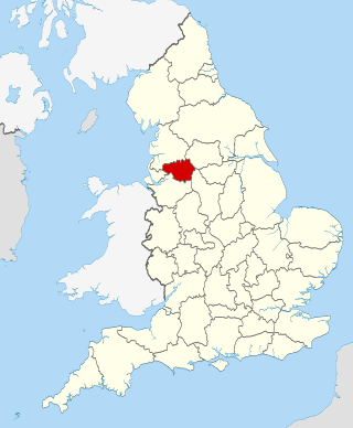
Greater London is an administrative area in England, coterminous with the London region, containing most of the continuous urban area of London. It contains 33 local government districts: the 32 London boroughs, which form a ceremonial county also called Greater London, and the City of London. The Greater London Authority is responsible for strategic local government across the region, and regular local government is the responsibility of the borough councils and the City of London Corporation. Greater London is bordered by the ceremonial counties of Hertfordshire to the north, Essex to the north-east, Kent to the south-east, Surrey to the south, and Berkshire and Buckinghamshire to the west.

