Edgware Road

Last updated

Edgware Road
UK road A5.svg
Edgeware Road.jpg
Edgware Road facing south from Church Street
Length9 mi (14 km)
Location London, United Kingdom
Postal code W2
North end Edgware
South end Marble Arch
Construction
Construction start43 A.D.
Other
Known forShopping, Lebanese cuisine, Marble Arch, Gaumont State Cinema, Tricycle Theatre, St Augustine's, Kilburn,

Edgware Road is a major road in London, England. The route originated as part of Roman Watling Street and, unusually in London, it runs for 10 miles in an almost perfectly straight line. Forming part of the modern A5 road, Edgware Road undergoes several name changes along its length, including Maida Vale, Kilburn High Road, Shoot Up Hill and Cricklewood Broadway; but the road is, as a whole, known as the Edgware Road, as it is the road to Edgware.

Contents

The road runs from central to suburban London, beginning at Marble Arch in the City of Westminster and heading north to Edgware in the London Borough of Barnet. It is used as the boundary for four London boroughs: Harrow and Brent to the west, and Barnet and Camden to the east.

Route

Edgware Road at Paddington EdgwRd.JPG
Edgware Road at Paddington

The road runs north-west from Marble Arch to Edgware on the outskirts of London. It crosses the Harrow Road and Marylebone Road, passing beneath the Marylebone flyover. The road passes through the areas of Maida Vale, Kilburn and Cricklewood. It then crosses the North Circular Road before West Hendon at Staples Corner. After this, the road continues in the same direction, through the Hyde, Colindale, Burnt Oak, and then reaches Edgware.

Shoot-up Hill, one of several names for Edgware Road. Kilburn road sign4.jpg
Shoot-up Hill, one of several names for Edgware Road.

The southernmost part of the Edgware Road forms part of the London Inner Ring Road and as such is part of the boundary of the London congestion charge zone. However, when the zone was extended in February 2007, the road became part of the "free through routes" which allows vehicles to cross the zone during its hours of operation without paying the charge.

The southern part of the road between Marble Arch and Maida Vale, noted for its distinct Middle Eastern cuisine and many late-night bars and shisha cafes, is known to Londoners by nicknames such as Little Cairo, [1] [2] Little Beirut [3] and, especially near Camden, Little Cyprus . [4] [5]

As it passes through the various neighbourhoods, the road name changes several times, becoming Maida Vale, Kilburn High Road and Shoot-Up Hill (in Kilburn), and Cricklewood Broadway (in Cricklewood), before becoming Edgware Road once again with intermittent stretches as West Hendon Broadway, and the Hyde. Along the entire route, it retains its identity as the A5 road under the Great Britain road numbering scheme. The A5 continues beyond the end of the Edgware Road, following the old Roman road for much of its route and terminating at Holyhead, Wales (a port for Ireland).

History

Roman Britain, with the route of Watling Street in red Watling Street route.jpg
Roman Britain, with the route of Watling Street in red
Hyde Park toll gate Hyde park turnpike toll gate.jpg
Hyde Park toll gate

Before the Romans, today's Edgware Road began as an ancient trackway within the Great Middlesex Forest. [6] The Romans later incorporated the track into Watling Street. [6]

Many centuries later, the road was improved by the Edgware-Kilburn turnpike trust in 1711, and a number of the local inns, functioned as stops for coaches, although they would have been quite close to the starting point of coach routes from London.

During the 18th century, it was a destination for Huguenot migrants. [6] By 1811, Thomas Telford produced a re-design for what was then known as a section of the London to Holyhead road, a redesign considered one of the most important feats of pre-Victorian engineering. [6] Telford's redesign emerged only a year after the area saw the establishment of Great Britain's first Indian restaurant. [6]

The area began to attract Arab migrants in the late 19th century during a period of increased trade with the Ottoman Empire. The trend continued with the arrival of Egyptians and Iraqis in the 1950s, and greatly expanded beginning in the 1970s and continuing to the present when events including the Lebanese Civil War and unrest in Algeria brought more Arabs to the area. [6] They established the present-day mix of bars and shisha cafes, which make the area known to Londoners by nicknames such as "Little Cairo" [2] [7] and "Little Beirut." [3] These shisha cafés have been hard hit by the enforcement of the England-wide smoking ban in 2007.

One of the two Edgware Road tube stations was one of the sites of the 7 July bombings. A bomb was detonated on a train leaving the tube station serving the Circle, District and Hammersmith & City lines and heading for Paddington tube station. Six people were killed in the blast: Colin Morley, 52, Jennifer Vanda Ann Nicholson, 24, Johnathan Downey, 34, Laura Webb, 29, Michael Brewster, 52, and David Foulkes, 22. The perpetrator was the ringleader of the 7 July bombings, Mohammed Siddique Khan. On the first anniversary of the bombings, a memorial plaque to the victims was unveiled at the station.

Districts and surrounding area

The name "Edgware Road" is used to refer to informally to this area of London, meaning the area immediately to the north of Marble Arch. The district's northern boundary is the Marylebone flyover. [6]

The postal codes of the area are W1, W2, NW1 and NW2.

The part of the road between Marble Arch and the Marylebone Flyover also separates the areas of Marylebone and Bayswater.

Sculpture "The Window Cleaner" by Allan Sly outside the tube station. EdgwareRoadStationStatue.jpg
Sculpture "The Window Cleaner" by Allan Sly outside the tube station.

Edgware Road is well represented in terms of communities from across the Middle East and North Africa. [8]

The 'Tyburn tree', once the principal site of executions in London Tyburn tree.jpg
The 'Tyburn tree', once the principal site of executions in London

Transport

A number 16 bus London Bus route 16.JPG
A number 16 bus
One of the Edgware Road tube stations Edgware Road (Circle) stn roundel.JPG
One of the Edgware Road tube stations

Edgware Road has several London bus routes, and is intersected by several London Underground lines along its length or nearby. A number of schemes have been put forward in the past to construct an Underground railway line underneath Edgware Road, including a plan to extend the Bakerloo line north to Cricklewood and an unusual proposal to build an underground monorail system, [9] but these schemes did not succeed. Today, London Buses provide the only public transport along the length of the road.

National Rail

Mainline and Overground rail stations:

London Underground

Bus routes

Night bus N16 is the only route to run the full length of the Edgware Road, from Victoria station to Edgware.

Day bus routes operating over a significant length of Edgware Road are:

Related Research Articles

<span class="mw-page-title-main">Kilburn, London</span> Area of London, England

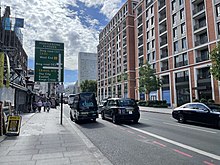
Kilburn is a locality on the boundary of three London Boroughs: Camden, Brent and the City of Westminster. Kilburn High Road railway station lies 3.5 miles (5.6 km) north-west of Charing Cross.

<span class="mw-page-title-main">Paddington</span> Area of central London, England

Paddington is an area in the City of Westminster, in central London, England. A medieval parish then a metropolitan borough, it was integrated with Westminster and Greater London in 1965. Paddington station, designed by the engineer Isambard Kingdom Brunel opened in 1847. It is also the site of St Mary's Hospital and the former Paddington Green Police Station.

<span class="mw-page-title-main">Marylebone Road</span> Road in London, England

Marylebone Road is an important thoroughfare in central London, within the City of Westminster. It runs east–west from the Euston Road at Regent's Park to the A40 Westway at Paddington. The road which runs in three lanes in both directions, is part of the London Inner Ring Road and as such forms part of the boundary of the zone within which the London congestion charge applies.

<span class="mw-page-title-main">Baker Street tube station</span> London Underground station

Baker Street is a London Underground station at the junction of Baker Street and the Marylebone Road in the City of Westminster. It is one of the original stations of the Metropolitan Railway (MR), the world's first underground railway, opened on 10 January 1863.

<span class="mw-page-title-main">Maida Vale tube station</span> London Underground station

Maida Vale is a London Underground station in Maida Vale in inner north-west London. The station is on the Bakerloo line, between Kilburn Park and Warwick Avenue stations, and is in Travelcard Zone 2.

<span class="mw-page-title-main">Kilburn Park tube station</span> London Underground station

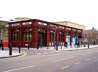
Kilburn Park is a London Underground station at Kilburn in the London Borough of Brent. The station is on the Bakerloo line, between Queen's Park and Maida Vale stations, and is in Travelcard Zone 2.

<span class="mw-page-title-main">Edgware Road tube station (Circle, District and Hammersmith & City lines)</span> London Underground station on the Circle, District and Hammersmith & City lines

Edgware Road is a London Underground station on the Circle, District and Hammersmith & City lines, located on the corner of Chapel Street and Cabbell Street, within Travelcard zone 1. A separate station of the same name but served by the Bakerloo line is located about 150 metres away on the opposite side of Marylebone Road.

<span class="mw-page-title-main">Brent Cross</span> Major interchange in the London Borough of Barnet, London

Brent Cross is a major traffic interchange and area in the London Borough of Barnet, England. Originally the name of a crossroads, it is located a mile from the centres of Hendon and Golders Green. Notably, the Brent Cross Shopping Centre, a major retail facility, was opened in 1976, south of the interchange. The "Brent Cross Flyover" A41 runs to the east of the shopping centre over the A406 North Circular Road, while the M1 motorway and A5 Edgware Road are to the west at Staples Corner interchange. In addition, the Northern line and Thameslink rail routes run on viaducts.

<span class="mw-page-title-main">Kilburn High Road railway station</span> London Overground station

Kilburn High Road railway station is a London Overground station on the London Euston to Watford DC Line near the south end of the Kilburn High Road, London NW6 in the London Borough of Camden.

<span class="mw-page-title-main">London Buses route 16</span> London bus route

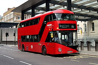
London Buses route 16 is a Transport for London contracted bus route in London, England. Running between Brent Park and Paddington station, it is operated by Metroline.

Stanley A. Heaps (1880–1962) was an English architect responsible for the design of a number of stations on the London Underground system as well as the design of train depots and bus and trolleybus garages for London Transport.

<span class="mw-page-title-main">Edgware Road tube station (Bakerloo line)</span> London Underground station on the Bakerloo line

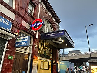
Edgware Road is a London Underground station on the Bakerloo line, located in the City of Westminster. It is between Paddington and Marylebone stations on the line and falls within Travelcard zone 1. The station is located on the north-east corner of the junction of Edgware Road, Harrow Road and Marylebone Road. It is adjacent to the Marylebone flyover.

<span class="mw-page-title-main">London Buses route 332</span> Former London bus route

London Buses route 332 was a Transport for London contracted bus route in London, England. It ran between Brent Park and Paddington station, and was operated by Metroline.

<span class="mw-page-title-main">A40 road in London</span> Major trunk road connecting London to Fishguard, Wales

The A40 is a major trunk road connecting London to Fishguard, Wales. The A40 in London starts in the City of London and passes through six London Boroughs: Camden, Westminster, Kensington & Chelsea, Hammersmith & Fulham, Ealing and Hillingdon, to meet the M40 motorway junction 1 at Denham, Buckinghamshire.

<span class="mw-page-title-main">Baker Street and Waterloo Railway</span> Underground railway company in London

The Baker Street and Waterloo Railway (BS&WR), also known as the Bakerloo tube, was a railway company established in 1893 that built a deep-level underground "tube" railway in London. The company struggled to fund the work, and construction did not begin until 1898. In 1900, work was hit by the financial collapse of its parent company, the London & Globe Finance Corporation, through the fraud of Whitaker Wright, its main shareholder. In 1902, the BS&WR became a subsidiary of the Underground Electric Railways Company of London (UERL) controlled by American financier Charles Yerkes. The UERL quickly raised the funds, mainly from foreign investors.

<span class="mw-page-title-main">Edgware Road Tube schemes</span>

Edgware Road Tube schemes covers a number of proposals to build an underground railway in London, UK at the end of the 19th century. Each scheme envisaged building some form of rail tunnel along the Edgware Road in north-west London towards Victoria railway station.

<span class="mw-page-title-main">Night buses in London</span> Series of night bus routes that serve Greater London

The London Night Bus network is a series of night bus routes that serve Greater London. Services broadly operate between the hours of 23:00 and 06:00.

<span class="mw-page-title-main">Little Venice</span> District in London, England

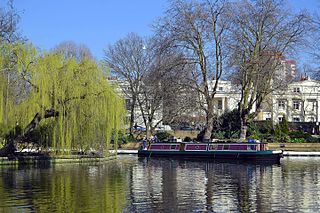
Little Venice is an affluent residential district in West London, England, around the junction of the Paddington Arm of the Grand Union Canal, the Regent's Canal, and the entrance to Paddington Basin. The junction forms a triangular shape basin. Many of the buildings in the vicinity are Regency white painted stucco terraced town houses and taller blocks (mansions) in the same style. The area is 2.5 miles (4.0 km) west-north-west of Charing Cross and immediately north-west of Paddington.

<span class="mw-page-title-main">Royal Commission on London Traffic</span> Former royal commission of the United Kingdom

The Royal Commission on London Traffic was a royal commission established in 1903 with a remit to review and report on how transport systems should be developed for London and the surrounding area. It produced a report in eight volumes published in 1905 and made recommendations on the character, administration and routing of traffic in London.

Maida Vale is an electoral ward of the City of Westminster. The population at the 2011 Census was 10,210. The ward covers the area south of Kilburn, north of Little Venice and west of St John's Wood, bordered by Maida Vale (A5), Shirland Road, Sutherland Avenue and Kilburn Park Road. The ward contains Paddington Recreation Ground, Lauderdale Road Spanish & Portuguese Synagogue, Saint Augustine's church and is home to the BBC Maida Vale Studios. The area is served by Maida Vale station on the Bakerloo line, in addition to several bus routes running through the locality. There are two primary schools, Essendine Primary School and St Augustine's Primary School, two secondary schools, St Augustine's CE High School and St. George's Catholic School, in addition to three GP surgeries located in the ward.

References

  1. Times Online: London high life hit as rich Arabs decamp, retrieved 29/03/07
  2. 1 2 Telegraph: Never talk about what you wear...
  3. 1 2 This Is London: Little Beirut
  4. Anthony, Andrew, "A Kentish Town killing", The Observer , 18 June 2000
  5. Clough, Eric A. and Quarmby, Jacqueline, (1978). A public library service for ethnic minorities in Great Britain, ISBN   978-0-85365-890-0, p.71
  6. 1 2 3 4 5 6 7 Working for the future of Edgware Road, a 2006 planning document (in PDF format) from the City of Westminster website
  7. Times Online: London high life hit as rich Arabs decamp, retrieved 29 March 2007
  8. BBC: Arabic London, retrieved 7 October 2007
  9. Badsey-Ellis, Antony (2005). London's Lost Tube Schemes. Capital Transport. ISBN   1-85414-293-3.

51°30′48″N0°09′37″W / 51.5133°N 0.1604°W / 51.5133; -0.1604