
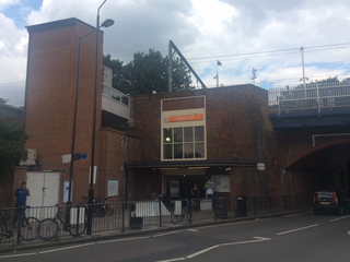
Clapham Junction railway station is a major railway station and transport hub near St John's Hill in southwest Battersea in the London Borough of Wandsworth. It is 2 miles 57 chains from London Victoria and 3 miles 74 chains from London Waterloo; it is on both the South West Main Line and Brighton Main Line as well as numerous other routes and branch lines passing through or diverging from the main lines at this station. Despite its name, Clapham Junction is not located in Clapham, a district situated approximately 1 mile (1.6 km) to the southeast and is instead sited in Battersea.

The North London line (NLL) is a railway line which passes through the inner suburbs of west, north-west, north, and north-east London, England between Richmond in the south-west and Stratford in the east, avoiding central London. Its route is a rough semicircle.

Kilburn is a London Underground station near Brondesbury Park in north-west London. It is on the Jubilee line, between Willesden Green and West Hampstead stations and is in Travelcard Zone 2. The station is on the A5 Kilburn High Road or Shoot-up Hill, approximately 0.1 miles (0.16 km) north of Brondesbury station. Metropolitan line trains typically bypass the station without stopping.

Surrey Quays is a station on the East London Line of the London Overground. It is located in Rotherhithe, part of London Borough of Southwark; it is in Zone 2. The next station to the north is Canada Water; to the south, it splits into branches to Clapham Junction, New Cross and Crystal Palace/West Croydon. Closed in late 2007 as an underground station, it was refurbished and reopened as part of the London Overground network on 27 April 2010.
Gospel Oak railway station is in the London Borough of Camden in north-west London. It is situated the North London line, served by Mildmay line services between Clapham Junction/Richmond and Stratford, and is also the western passenger terminus of the Gospel Oak to Barking Line, served by Suffragette line services to/from Barking Riverside. Passengers using Oyster cards are required to tap on interchange Oyster card readers when changing between the two lines. The station is in Travelcard Zone 2, and is managed by London Overground which runs all passenger trains at the station.

Kensington (Olympia) is a combined rail and tube station in Kensington, in West London. Services are provided by London Overground, who manage the station, along with Southern and London Underground. It is in Travelcard Zone 2. On the Underground it is the terminus of a short District line branch from Earl's Court, originally built as part of the Middle Circle. On the main-line railway it is on the West London Line from Clapham Junction to Willesden Junction, by which trains bypass inner London. The station's name is drawn from its location in Kensington and the adjacent Olympia exhibition centre in West Kensington.
The North London Railway (NLR) company had lines connecting the northern suburbs of London with the East and West India Docks further east. The main east to west route is now part of London Overground's North London Line. Other NLR lines fell into disuse but were later revived as part of the Docklands Light Railway, and London Overground's East London Line. The company was originally called the East & West India Docks & Birmingham Junction Railway (E&WID&BJR) from its start in 1850, until 1853. In 1909, it entered into an agreement with the London and North Western Railway which introduced common management, and the NLR was taken over completely by the LNWR in 1922. The LNWR itself became part of the LMS from the start of 1923. The railways were nationalised in 1948 and most LMS lines, including the North London route, then came under the control of the London Midland Region of British Railways.

Acton Central railway station is on the London Overground, between South Acton and Willesden Junction, in Travelcard Zone 3. It is also where trains change power supply from overhead line equipment to third rail, or vice versa, depending on direction of travel.

Brondesbury Park railway station is a National Rail station in Brondesbury Park in the London Borough of Brent on the North London line in Travelcard Zone 2 which is managed by London Overground. It is close to the Queen's Park area.

Hampstead Heath railway station is in the London Borough of Camden in north London on the North London Line, between Finchley Road & Frognal and Gospel Oak stations, and is in Travelcard Zone 2. Since 11 November 2007 it and the service there have been run by London Overground. It is located on South End Road close to South End Green and Pond Street in the old South End of Hampstead.

Hackney Central is a London Overground station on the North London line in Hackney Central, north-east London. It lies between Dalston Kingsland and Homerton and is in Travelcard Zone 2. The station and all trains serving it are operated by London Overground services which are managed by Transport for London. However, there is no standard red National Rail "double arrow" logo signage at the station, instead only the Overground roundel.
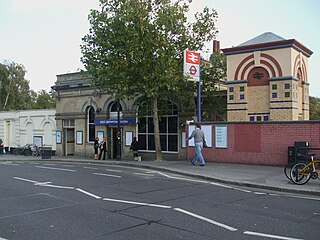
West Brompton is a London Underground, London Overground and National Rail station on Old Brompton Road (A3218) in West Brompton, located in west London, and is on the District line and West London Line (WLL). It is immediately south of the demolished Earls Court Exhibition Centre and west of Brompton Cemetery in the Royal Borough of Kensington and Chelsea.
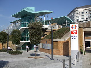
Imperial Wharf is a London Overground and National Rail station located in Sands End in west London on the West London line, and is next to Chelsea Harbour. The station is between West Brompton and Clapham Junction stations and services are provided by London Overground and Southern.

Hackney Wick is a station on the North London Line in the area of Hackney Wick, East London. It is in Travelcard Zone 2. The station and all trains serving it are operated by London Overground. It opened on 12 May 1980 by British Rail as part of the Crosstown Linkline service between North Woolwich and Camden Road stations. Between Spring 2017 and May 2018 the station was rebuilt and modernised, including replacement of the footbridge by a subway. The new subway, in addition to linking the two platforms will, later in 2018, provide a cycle and pedestrian link between Hackney and Tower Hamlets.
Finchley Road & Frognal railway station is on Finchley Road in the London Borough of Camden in north London. It is on the North London line, and the station and all trains serving it are operated by London Overground. It is in Travelcard Zone 2. The station is about five minutes walk from Finchley Road Underground station, and is marked as an official out-of-system interchange. The station was opened as Finchley Road St Johns Wood in 1860 on the Hampstead Junction Railway for the connection to the North London Railway.

Cricklewood railway station is on the Midland Main Line in England, serving the town of Cricklewood in the London Borough of Barnet, north London. It is 5 miles 9 chains (8.2 km) down the line from St Pancras and is situated between West Hampstead Thameslink to the south and Brent Cross West to the north. Its three-letter station code is CRI.

Kensal Rise is a London Overground station on the North London line on Chamberlayne Road, Kensal Rise in north-west London. The station is in Fare Zone 2.

West Hampstead Thameslink is a National Rail station on the Midland Main Line and is served by Thameslink trains as part of the Thameslink route between Kentish Town and Cricklewood. The station is in Travelcard Zone 2.

West Hampstead railway station is a London Overground station on the North London Line between Brondesbury and Finchley Road & Frognal in the London Borough of Camden and is in Travelcard Zone 2.
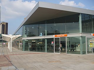
Shepherd's Bush station is a railway station located in the district of Shepherd's Bush in Greater London, England, UK. It opened on 29 September 2008 on the West London line and is served by London Overground and Southern rail services. It lies within Travelcard Zone 2.


