
The District line is a London Underground line running from Upminster in the east and Edgware Road in the west to Earl's Court in west London, where it splits into multiple branches. One branch runs to Wimbledon in south-west London and a short branch, with a limited service, only runs for one stop to Kensington (Olympia). The main route continues west from Earl's Court to Turnham Green after which it divides again into two western branches, to Richmond and Ealing Broadway.

The Hammersmith & City line is a London Underground line that runs between Hammersmith in west London and Barking in east London. Printed in pink on the Tube map, it serves 29 stations over 15.8 miles (25.5 km). Between Farringdon and Aldgate East it skirts the City of London, the capital's financial heart, hence the line's name. Its tunnels are just below the surface and are a similar size to those on British main lines. Most of the track and all stations are shared with either the District, Circle, or Metropolitan lines. Over 114 million passenger journeys are made each year on the Hammersmith & City and Circle lines.

The Jubilee line is a London Underground line that runs between Stratford in east London and Stanmore in the suburban north-west, via the Docklands, South Bank and West End. Opened in 1979, it is the newest line on the Underground network, although some sections of track date back to 1932 and some stations to 1879.

The Northern line is a London Underground line that runs from North London to South London. It is printed in black on the Tube map. The Northern line is unique on the Underground network in having two different routes through central London, two southern branches and two northern branches. Despite its name, it does not serve the northernmost stations on the Underground, though it does serve the southernmost station at Morden, the terminus of one of the two southern branches.

The North London line (NLL) is a railway line which passes through the inner suburbs of west, north-west, north, and east London, England between Richmond in the south-west and Stratford in the east, avoiding central London. Its route is a rough semicircle.

Kentish Town is a London Underground and National Rail station in Kentish Town in the London Borough of Camden. It is at the junction of Kentish Town Road (A400) and Leighton Road. It is in Travelcard Zone 2. The station is served by the High Barnet branch of the London Underground Northern line, and by Thameslink trains on the National Rail Midland Main Line. It is the only station on the High Barnet branch with a direct interchange with a National Rail line; furthermore an Out of Station Interchange (OSI) with Kentish Town West on the North London line is not charged as two separate journeys in electronic journey charging.

Gospel Oak is an inner urban area of north west London in the London Borough of Camden at the very south of Hampstead Heath. The neighbourhood is positioned between Hampstead to the north-west, Dartmouth Park to the north-east, Kentish Town to the south-east, and Belsize Park to the south-west. Gospel Oak lies across the NW5 and NW3 postcodes and is served by Gospel Oak station on the London Overground. The North London Suburb, Gospel Oak, has many schools around it.
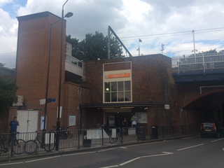
Gospel Oak railway station is in the London Borough of Camden in north-west London. It is on the North London line (NLL) and is also the western passenger terminus of the Gospel Oak to Barking Line – known informally as GOBLIN. Passengers using Oyster cards are required to tap on interchange Oyster card readers when changing between the two lines. The station is in Travelcard Zone 2, and is managed by London Overground which runs all passenger trains at the station.
The Gospel Oak to Barking line is a railway line in London. It is 13 miles 58 chains (22.1 km) in length and carries both through goods trains and London Overground passenger trains, connecting Gospel Oak in north London and Barking Riverside in east London. The line is part of Network Rail Strategic Route 6, and is classified as a London and South East Commuter line.
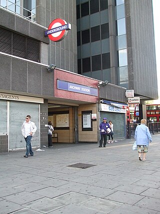
Archway is a London Underground station at the intersection of Holloway Road, Highgate Hill, Junction Road and Archway Road in Archway, north London, directly underneath the Vantage Point building. It is on the High Barnet branch of the Northern line, between Highgate and Tufnell Park stations, in Zones 2 and 3.

Tufnell Park is a London Underground station in Islington, close to its boundary with Camden. It is located in the Tufnell Park neighbourhood. It is on the High Barnet branch of the Northern line, between Archway and Kentish Town stations, and in Travelcard Zone 2.
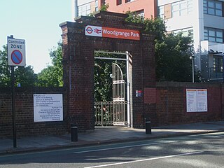
Woodgrange Park railway station is a railway station on Romford Road in Manor Park in the London Borough of Newham, east London. It is served by London Overground, and is on the Gospel Oak to Barking line, 12 miles 1 chain (19.3 km) down the line from Gospel Oak; it lies in Travelcard Zones 3 and 4. It has only limited station buildings and facilities.

Tottenham Hale is a National Rail and London Underground interchange station located in Tottenham Hale in north London, England. On the National Rail network it is on the West Anglia Main Line, 6 miles (9.7 km) from London Liverpool Street, and is served by Greater Anglia and Stansted Express. On the Underground it is on the Victoria line between Blackhorse Road and Seven Sisters. The station is in Travelcard Zone 3.

South Hampstead railway station is on Loudoun Road in the London Borough of Camden. It is served by London Overground services on the Watford DC line. It is about 550 yards (500 m) south west of Swiss Cottage Underground station.

Victoria Park was a railway station near Victoria Park, east London, that was on the North London Railway (NLR) which opened in September 1850 to Bow and to the London Docks in January 1852.

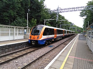
London Overground is a suburban rail network serving London and its environs. Established in 2007 to take over Silverlink Metro routes, it now serves a large part of Greater London as well as the home county of Hertfordshire, with 113 stations on nine different routes.

The Dudding Hill Line is a railway line in west and north-west London running from Acton to Cricklewood. It is roughly 4 miles (6.4 km) long, with a 30 miles per hour (48 km/h) speed limit, and semaphore signalling. The line has no scheduled passenger service, no stations, and is not electrified. It is lightly used by freight trains and, very occasionally, passenger charter trains.
The North and South Western Junction Railway (NSWJR) was a short railway in west London, England. It opened in 1853, connecting Willesden on the London and North Western Railway (LNWR) with Brentford on the London and South Western Railway (LSWR). After a difficult start it became an important freight route and that usage continues today. A passenger service linked LSWR stations with the North London Railway, and a branch was built to Hammersmith.

Hornsey Road railway station was a station on Hornsey Road, near Finsbury Park, in the London Borough of Islington, which was opened in 1872 by the Tottenham & Hampstead Junction Railway. It was between Upper Holloway and Crouch Hill stations, on the line now known as the Gospel Oak to Barking Line. It was closed in 1943, and demolished soon afterwards. Its closure was due to wartime constraints and its proximity to the neighbouring stations.
The A400 road is an A road in London that runs from Charing Cross to Archway in North London. It passes some of London's most famous landmarks.


